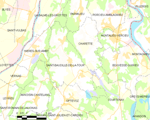
Шаретт (Charette, Charette)

- коммуна во Франции
 Hiking in Шаретт
Charette is a small commune located in the Isère department of the Auvergne-Rhône-Alpes region in southeastern France. This area is known for its scenic landscapes, diverse terrain, and opportunities for outdoor activities, including hiking.
Hiking in Charette, Isère
-
Scenic Trails: The vicinity of Charette offers a variety of hiking trails that cater to different skill levels. You can enjoy lush forests, rolling hills, and panoramic views of the surrounding Alps and the Vercors Massif.
-
Nature & Wildlife: The region is home to diverse flora and fauna. As you hike, you may encounter various bird species, deer, and other wildlife, especially in the more remote areas.
-
Local Culture: Hiking around Charette allows you to experience the local culture and heritage of the region. You can often find quaint villages, traditional Alpine architecture, and lovely viewpoints that reflect the area's history.
-
Accessibility: Many trails in the Isère department are well-marked and can be accessed easily from Charette. Some paths may require driving to reach trailheads, but many are walkable if you are starting from the village itself.
-
Best Time to Hike: The best time for hiking in Charette typically ranges from late spring (May) to early autumn (September). During these months, the weather is generally mild, and the trails are accessible.
-
Safety & Preparation: As with any hiking experience, it’s essential to prepare accordingly. Bring adequate gear, check the weather conditions, and inform someone about your hiking plans. Always stay on marked trails and respect nature to help preserve the environment.
-
Nearby Attractions: If you have more time, consider exploring other nearby hiking destinations such as the Vercors Regional Natural Park or Chartreuse Massif, both of which offer extensive trails and breathtaking scenery.
Conclusion
Hiking in Charette, Isère, presents a wonderful opportunity to immerse yourself in beautiful natural settings, enjoy the local culture, and experience the tranquility of the French countryside. Whether you are an experienced hiker or just looking to enjoy a leisurely walk in nature, there's something for everyone in this picturesque region. Be sure to check local maps and guides for the best routes and conditions before you head out!
- Страна:

- Почтовый код: 38390
- Координаты: 45° 48' 37" N, 5° 22' 14" E


- GPS треки (wikiloc): [Ссылка]
- Площадь: 11.26 кв.км
- Население: 464
- Википедия русская: wiki(ru)
- Википедия английская: wiki(en)
- Википедия национальная: wiki(fr)
- Хранилище Wikidata: Wikidata: Q1002995
- Катеория в википедии: [Ссылка]
- код Freebase: [/m/03nvgft]
- код GeoNames: Альт: [6448751]
- номер SIREN: [213800832]
- код BNF: [152579112]
- код тезауруса PACTOLS: [pcrt5OcGrL2hOY]
- код муниципалитета INSEE: 38083
Граничит с регионами:


Куртене
- коммуна во Франции
Hiking in Куртене
Courtenay, located in the Isère department of France, is surrounded by beautiful mountainous landscapes, making it a great destination for hiking enthusiasts. Here are some highlights and considerations for hiking in the area:...
- Страна:
- Почтовый код: 38510
- Координаты: 45° 43' 45" N, 5° 22' 45" E
- GPS треки (wikiloc): [Ссылка]
- Площадь: 32.08 кв.км
- Население: 1276
- Веб сайт: [Ссылка]

Сен-Бодий-де-ла-Тур
- коммуна во Франции
Hiking in Сен-Бодий-де-ла-Тур
Saint-Baudille-de-la-Tour is a charming commune located in the Isère department in the Auvergne-Rhône-Alpes region of southeastern France. It serves as an excellent starting point for outdoor activities, including hiking, thanks to its scenic landscapes and proximity to the Alps....
- Страна:
- Почтовый код: 38118
- Координаты: 45° 47' 23" N, 5° 20' 18" E
- GPS треки (wikiloc): [Ссылка]
- Площадь: 21.76 кв.км
- Население: 797
- Веб сайт: [Ссылка]


Пармильё
- коммуна во Франции
Hiking in Пармильё
Parmilieu is a charming commune located in the Isère department of the Auvergne-Rhône-Alpes region in southeastern France. The area is characterized by its beautiful natural scenery, which offers excellent opportunities for hiking and outdoor activities. Here are some highlights and tips for hiking in and around Parmilieu:...
- Страна:
- Почтовый код: 38390
- Координаты: 45° 50' 25" N, 5° 21' 18" E
- GPS треки (wikiloc): [Ссылка]
- Площадь: 12.83 кв.км
- Население: 691
- Веб сайт: [Ссылка]


Монтальё-Версьё
- коммуна во Франции
Hiking in Монтальё-Версьё
Montalieu-Vercieu is a charming commune located in the Ain department of the Auvergne-Rhône-Alpes region in southeastern France. The surrounding area offers various hiking opportunities, making it an attractive destination for outdoor enthusiasts....
- Страна:
- Почтовый код: 38390
- Координаты: 45° 48' 51" N, 5° 24' 13" E
- GPS треки (wikiloc): [Ссылка]
- Площадь: 8.66 кв.км
- Население: 3387
- Веб сайт: [Ссылка]


Порсьё-Амбланьё
- коммуна во Франции
Hiking in Порсьё-Амбланьё
Porcieu-Amblagnieu is a charming commune located in the Isère department of the Auvergne-Rhône-Alpes region in France. This area is characterized by its beautiful natural landscapes, rolling hills, and proximity to the Alps, making it a fantastic destination for hiking enthusiasts....
- Страна:
- Почтовый код: 38390
- Координаты: 45° 50' 3" N, 5° 24' 4" E
- GPS треки (wikiloc): [Ссылка]
- Площадь: 15.8 кв.км
- Население: 1759
- Веб сайт: [Ссылка]


Бувес-Кирьё
- коммуна во Франции
Hiking in Бувес-Кирьё
Bouvesse-Quirieu is a small commune located in the Auvergne-Rhône-Alpes region of France, which offers a scenic backdrop for hiking enthusiasts. The area is characterized by its lush greenery, rolling hills, and diverse landscapes....
- Страна:
- Почтовый код: 38390
- Координаты: 45° 47' 43" N, 5° 24' 53" E
- GPS треки (wikiloc): [Ссылка]
- Площадь: 17.51 кв.км
- Население: 1504
- Веб сайт: [Ссылка]