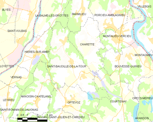
Куртене (Courtenay, Courtenay)

- коммуна во Франции
 Hiking in Куртене
Courtenay, located in the Isère department of France, is surrounded by beautiful mountainous landscapes, making it a great destination for hiking enthusiasts. Here are some highlights and considerations for hiking in the area:
Scenic Trails
-
Alpes Dauphinés: The nearby Alps offer a variety of trails that range from easy walks to challenging mountain hikes. Many routes provide stunning views of the surrounding peaks and valleys.
-
Vercors Regional Natural Park: Not far from Courtenay, this park has numerous trails that feature limestone cliffs, deep gorges, and diverse flora and fauna. The park is well-marked and offers hikes suitable for all skill levels.
-
Belledonne Mountains: These mountains are known for their rugged beauty, with various trails leading to alpine lakes, ridges, and panoramic viewpoints. Hikes in this area can be quite challenging, so it's advisable to have some experience if you choose these routes.
Recommendations
-
Start with Easier Trails: If you're new to hiking or unfamiliar with the area, begin with shorter, well-marked trails to build your confidence.
-
Check the Weather: Mountain weather can change rapidly. Always check the forecast before heading out and be prepared for different conditions.
-
Gear Up: Wear appropriate hiking boots, and carry a map, water, snacks, and a first-aid kit. Depending on the season, layers and waterproof clothing may also be necessary.
-
Respect Nature: Stick to marked trails, and practice Leave No Trace principles to help preserve the natural beauty of the area.
Local Guides and Resources
Consider hiring a local guide or joining a hiking group to gain insights into the best trails and hidden gems in the region. Local tourist offices can also provide maps and can recommend popular routes based on your hiking experience and interests.
Conclusion
Hiking in and around Courtenay in the Isère department offers a fantastic opportunity to experience the natural beauty of the French Alps. With diverse trails catering to various skill levels, there's something for everyone to enjoy. Happy hiking!
- Страна:

- Почтовый код: 38510
- Координаты: 45° 43' 45" N, 5° 22' 45" E


- GPS треки (wikiloc): [Ссылка]
- Площадь: 32.08 кв.км
- Население: 1276
- Веб сайт: http://www.courtenay38.fr
- Википедия русская: wiki(ru)
- Википедия английская: wiki(en)
- Википедия национальная: wiki(fr)
- Хранилище Wikidata: Wikidata: Q1003007
- Катеория в википедии: [Ссылка]
- код Freebase: [/m/03nvhk6]
- код GeoNames: Альт: [6454066]
- номер SIREN: [213801350]
- код BNF: [15257958q]
- код VIAF: Альт: [125620385]
- код LCNAF: Альт: [n90707125]
- код муниципалитета INSEE: 38135
Граничит с регионами:


Крей-Мепьё
- коммуна во Франции
Hiking in Крей-Мепьё
Creys-Mépieu is a charming area located in the Auvergne-Rhône-Alpes region of France. While it may not be one of the most widely recognized hiking destinations, it offers some lovely outdoor experiences for those looking to explore its natural beauty....
- Страна:
- Почтовый код: 38510
- Координаты: 45° 43' 42" N, 5° 29' 16" E
- GPS треки (wikiloc): [Ссылка]
- Высота над уровнем моря: 260 м m
- Площадь: 28.99 кв.км
- Население: 1543
- Веб сайт: [Ссылка]


Шаретт
- коммуна во Франции
Hiking in Шаретт
Charette is a small commune located in the Isère department of the Auvergne-Rhône-Alpes region in southeastern France. This area is known for its scenic landscapes, diverse terrain, and opportunities for outdoor activities, including hiking....
- Страна:
- Почтовый код: 38390
- Координаты: 45° 48' 37" N, 5° 22' 14" E
- GPS треки (wikiloc): [Ссылка]
- Площадь: 11.26 кв.км
- Население: 464

Сен-Бодий-де-ла-Тур
- коммуна во Франции
Hiking in Сен-Бодий-де-ла-Тур
Saint-Baudille-de-la-Tour is a charming commune located in the Isère department in the Auvergne-Rhône-Alpes region of southeastern France. It serves as an excellent starting point for outdoor activities, including hiking, thanks to its scenic landscapes and proximity to the Alps....
- Страна:
- Почтовый код: 38118
- Координаты: 45° 47' 23" N, 5° 20' 18" E
- GPS треки (wikiloc): [Ссылка]
- Площадь: 21.76 кв.км
- Население: 797
- Веб сайт: [Ссылка]


Пасен
- коммуна во Франции
Hiking in Пасен
Passins is a picturesque village located in the Auvergne-Rhône-Alpes region of France, near the foothills of the French Alps. While it may not be as widely known as larger hiking destinations, Passins and its surrounding areas offer a variety of beautiful hiking opportunities that cater to different skill levels....
- Страна:
- Почтовый код: 38510
- Координаты: 45° 41' 16" N, 5° 25' 46" E
- GPS треки (wikiloc): [Ссылка]
- Площадь: 13.92 кв.км
- Население: 1168
- Веб сайт: [Ссылка]

Солеймьё
- коммуна во Франции
Hiking in Солеймьё
Soleymieu, located in the Auvergne-Rhône-Alpes region of France, offers a delightful environment for hiking enthusiasts with its picturesque landscapes and varied terrains. Here are some key points to consider when planning a hike in Soleymieu:...
- Страна:
- Почтовый код: 38460
- Координаты: 45° 42' 35" N, 5° 20' 59" E
- GPS треки (wikiloc): [Ссылка]
- Площадь: 13.36 кв.км
- Население: 776


Арандон
- коммуна во Франции
Hiking in Арандон
Arandon is not widely recognized as a primary hiking destination, and information can vary depending on which specific region you mean, as there might be various places or trails with similar names. It's important to clarify or specify a particular area, as many locations around the world offer beautiful hiking opportunities under various names....
- Страна:
- Почтовый код: 38510
- Координаты: 45° 42' 39" N, 5° 25' 45" E
- GPS треки (wikiloc): [Ссылка]
- Площадь: 12.22 кв.км
- Население: 623
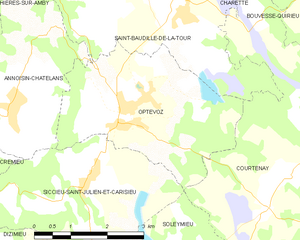
Оптевоз
- коммуна во Франции
Hiking in Оптевоз
Optevoz is a charming commune in the Isère department of the Auvergne-Rhône-Alpes region in southeastern France. While it may not be one of the most famous hiking destinations, it offers a beautiful backdrop for outdoor activities, including hiking, especially if you enjoy picturesque views and a more tranquil setting away from larger tourist crowds....
- Страна:
- Почтовый код: 38460
- Координаты: 45° 45' 9" N, 5° 19' 53" E
- GPS треки (wikiloc): [Ссылка]
- Площадь: 12 кв.км
- Население: 829
- Веб сайт: [Ссылка]


Бувес-Кирьё
- коммуна во Франции
Hiking in Бувес-Кирьё
Bouvesse-Quirieu is a small commune located in the Auvergne-Rhône-Alpes region of France, which offers a scenic backdrop for hiking enthusiasts. The area is characterized by its lush greenery, rolling hills, and diverse landscapes....
- Страна:
- Почтовый код: 38390
- Координаты: 45° 47' 43" N, 5° 24' 53" E
- GPS треки (wikiloc): [Ссылка]
- Площадь: 17.51 кв.км
- Население: 1504
- Веб сайт: [Ссылка]