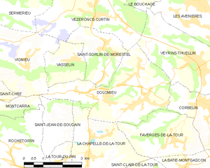
Корбелен (Corbelin, Corbelin)

- коммуна во Франции
 Hiking in Корбелен
Corbelin is a charming village located in the Auvergne-Rhône-Alpes region of France, and it offers a variety of outdoor activities, including hiking. The area is known for its scenic landscapes, wooded hills, and proximity to natural reserves, making it an ideal spot for those who enjoy immersing themselves in nature.
Hiking Trails
-
La Chartreuse de Portes: This area offers beautiful forested trails that are manageable for various skill levels. Hikers can enjoy the lush greenery and serene surroundings.
-
Les Bords du Rhône: For those who prefer riverside views, this trail runs along the Rhône River and features picturesque views of the water and the surrounding countryside.
-
Mont Tournette: A bit more challenging, this trail leads to a stunning viewpoint with panoramic views of the region. It’s suitable for more experienced hikers looking for a rewarding trek.
Best Time to Hike
The best times to hike in Corbelin are during the spring (April to June) and fall (September to October) when the weather is pleasant, and the landscapes showcase vibrant colors. Summer can be warm, while winter months may pose challenges with snow and ice.
Preparation Tips
- Footwear: Good hiking boots are essential for rocky and uneven terrain.
- Water and Snacks: Always carry sufficient water and some trail snacks, especially on longer hikes.
- Navigation: While many trails are marked, a map or GPS device can be helpful.
- Weather Check: Always check the weather before embarking on your hike to ensure safe conditions.
Safety Considerations
- Inform someone about your hiking plans and estimated return time.
- Be mindful of wildlife and respect their habitats.
- If hiking alone, choose routes that are well-traveled and safe.
Conclusion
Hiking in Corbelin can be a rewarding experience, allowing you to enjoy the natural beauty of the Rhône-Alpes region. With various trails to suit different skill levels, it’s a fantastic destination for both novice and experienced hikers. Always prioritize safety and enjoy your adventure!
- Страна:

- Почтовый код: 38630
- Координаты: 45° 36' 27" N, 5° 32' 41" E


- GPS треки (wikiloc): [Ссылка]
- Площадь: 12 кв.км
- Население: 2223
- Веб сайт: http://www.corbelin.fr
- Википедия русская: wiki(ru)
- Википедия английская: wiki(en)
- Википедия национальная: wiki(fr)
- Хранилище Wikidata: Wikidata: Q1153208
- Катеория в википедии: [Ссылка]
- код Freebase: [/m/03nvh7y]
- код Freebase: [/m/03nvh7y]
- код GeoNames: Альт: [6433174]
- код GeoNames: Альт: [6433174]
- номер SIREN: [213801244]
- номер SIREN: [213801244]
- код BNF: [152579472]
- код BNF: [152579472]
- код муниципалитета INSEE: 38124
- код муниципалитета INSEE: 38124
Граничит с регионами:


Фаверж-де-ла-Тур
- коммуна во Франции
Hiking in Фаверж-де-ла-Тур
Faverges-de-la-Tour, located in the Isère department in the Auvergne-Rhône-Alpes region of France, offers a range of hiking opportunities that showcase the natural beauty of the surrounding area. The region is characterized by its picturesque landscapes, including hills, woodlands, and stunning views of the nearby mountains....
- Страна:
- Почтовый код: 38110
- Координаты: 45° 35' 28" N, 5° 31' 25" E
- GPS треки (wikiloc): [Ссылка]
- Площадь: 7.67 кв.км
- Население: 1330
- Веб сайт: [Ссылка]


Граньё
- коммуна во Франции
Hiking in Граньё
Granieu is a charming village nestled in the picturesque French Alps, making it a fantastic destination for hiking enthusiasts. Its location offers access to a variety of trails that cater to different skill levels, from gentle walks to challenging ascents. Here are some highlights for hiking in the Granieu area:...
- Страна:
- Почтовый код: 38490
- Координаты: 45° 35' 58" N, 5° 35' 19" E
- GPS треки (wikiloc): [Ссылка]
- Площадь: 3.73 кв.км
- Население: 482

Доломьё
- коммуна во Франции
Hiking in Доломьё
Hiking in Dolomieu, Isère can be a wonderful experience, offering stunning landscapes and diverse trails. While Dolomieu is a small town, it is surrounded by natural beauty and is close to the Vercors and Chartreuse mountain ranges, which provide a variety of hiking opportunities....
- Страна:
- Почтовый код: 38110
- Координаты: 45° 36' 39" N, 5° 29' 57" E
- GPS треки (wikiloc): [Ссылка]
- Площадь: 13.32 кв.км
- Население: 3079
- Веб сайт: [Ссылка]


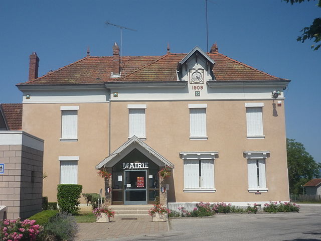
Ла-Бати-Монгаскон
- коммуна во Франции
Hiking in Ла-Бати-Монгаскон
La Bâtie-Montgascon is a charming village located in the Auvergne-Rhône-Alpes region of France, near the foothills of the Alps. The area is rich with natural beauty and offers various hiking opportunities for outdoor enthusiasts....
- Страна:
- Почтовый код: 38110
- Координаты: 45° 34' 45" N, 5° 31' 41" E
- GPS треки (wikiloc): [Ссылка]
- Площадь: 8.43 кв.км
- Население: 1890
- Веб сайт: [Ссылка]
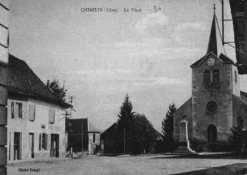

Шимьен
- коммуна во Франции
Hiking in Шимьен
Chimilin might refer to a specific region or area, but it doesn’t appear to be widely recognized as a hiking destination in available resources or discussions up to October 2023. However, if you are referring to a specific place known for hiking, such as Chimilin National Park or another similar-sounding location, please clarify....
- Страна:
- Почтовый код: 38490
- Координаты: 45° 34' 37" N, 5° 35' 58" E
- GPS треки (wikiloc): [Ссылка]
- Площадь: 9.66 кв.км
- Население: 1467
- Веб сайт: [Ссылка]

Верен-Тюэллен
- коммуна во Франции
Hiking in Верен-Тюэллен
Veyrins-Thuellin is a picturesque commune located in the Auvergne-Rhône-Alpes region of France. It offers several opportunities for hiking enthusiasts to enjoy the beautiful natural landscapes, rolling hills, and scenic views of the nearby mountains, particularly the Chartreuse and the Massif de Belledonne....
- Страна:
- Почтовый код: 38630
- Координаты: 45° 37' 32" N, 5° 32' 21" E
- GPS треки (wikiloc): [Ссылка]
- Высота над уровнем моря: 235 м m
- Площадь: 11.56 кв.км
- Население: 2060
- Веб сайт: [Ссылка]