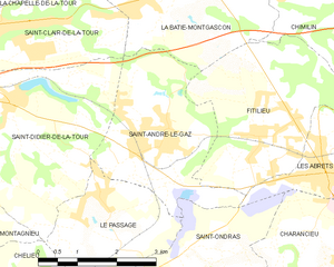
Ла-Бати-Монгаскон (La Bâtie-Montgascon, La Bâtie-Montgascon)

- коммуна во Франции
 Hiking in Ла-Бати-Монгаскон
La Bâtie-Montgascon is a charming village located in the Auvergne-Rhône-Alpes region of France, near the foothills of the Alps. The area is rich with natural beauty and offers various hiking opportunities for outdoor enthusiasts.
Hiking Trails
Here are some highlights of hiking in and around La Bâtie-Montgascon:
-
Scenic Views: The region features beautiful landscapes, including rolling hills, forests, and picturesque meadows. Many trails offer panoramic views of the surrounding mountains and valleys.
-
Rural Pathways: The hiking routes often take you through quaint villages, vineyards, and farmland, allowing you to immerse yourself in the rural culture of the area.
-
Diversity of Trails: Whether you are a beginner or an experienced hiker, there are trails suitable for all levels. You can find short family-friendly walks as well as more challenging hikes that lead to higher elevations.
-
Wildlife and Flora: The diverse ecosystems in the area are home to various wildlife species and unique plant life. Keep your camera ready for potential sightings!
-
Access to Nearby Parks: La Bâtie-Montgascon is close to natural reserves and parks, such as the Parc Naturel Régional de la Chartreuse and the Vercors region, offering extended hiking options.
Preparation Tips
- Maps and GPS: Make sure to bring a map or GPS device to navigate, as not all trails are well-marked.
- Proper Footwear: Wear sturdy hiking boots for comfort and support, especially on rocky or uneven terrain.
- Weather Awareness: The weather can change rapidly, particularly in the mountains. Always check the forecast and dress in layers.
- Stay Hydrated: Bring enough water and snacks to keep your energy up during your hikes.
Local Culture
After your hikes, you might want to explore local cuisine and culture in La Bâtie-Montgascon. Look out for local markets and restaurants where you can taste traditional dishes that reflect the agricultural heritage of the region.
Whether you’re looking for peaceful walks or more challenging treks, hiking around La Bâtie-Montgascon offers a unique chance to connect with nature and enjoy the serene beauty of the French countryside.
- Страна:

- Почтовый код: 38110
- Координаты: 45° 34' 45" N, 5° 31' 41" E


- GPS треки (wikiloc): [Ссылка]
- Площадь: 8.43 кв.км
- Население: 1890
- Веб сайт: http://www.batie-montgascon.com
- Википедия русская: wiki(ru)
- Википедия английская: wiki(en)
- Википедия национальная: wiki(fr)
- Хранилище Wikidata: Wikidata: Q177513
- Катеория в википедии: [Ссылка]
- код Freebase: [/m/03g_75p]
- код Freebase: [/m/03g_75p]
- код GeoNames: Альт: [6456869]
- код GeoNames: Альт: [6456869]
- номер SIREN: [213800295]
- номер SIREN: [213800295]
- код BNF: [15257858f]
- код BNF: [15257858f]
- код муниципалитета INSEE: 38029
- код муниципалитета INSEE: 38029
Граничит с регионами:


Сен-Клер-де-ла-Тур
- коммуна во Франции
Hiking in Сен-Клер-де-ла-Тур
Saint-Clair-de-la-Tour, located in the Auvergne-Rhône-Alpes region of France, offers some beautiful hiking opportunities amid its scenic landscapes. Here are some highlights if you're considering hiking in the area:...
- Страна:
- Почтовый код: 38110
- Координаты: 45° 34' 26" N, 5° 28' 55" E
- GPS треки (wikiloc): [Ссылка]
- Площадь: 9.24 кв.км
- Население: 3365
- Веб сайт: [Ссылка]

Сент-Андре-ле-Газ
- коммуна во Франции
Hiking in Сент-Андре-ле-Газ
Saint-André-le-Gaz, located in the Auvergne-Rhône-Alpes region of France, offers a delightful experience for hikers and outdoor enthusiasts. Nestled at the foothills of the Chartreuse Mountains and near the Rhône Valley, this area provides a range of trails suitable for various skill levels, from leisurely walks to more challenging hikes....
- Страна:
- Почтовый код: 38490
- Координаты: 45° 32' 56" N, 5° 32' 3" E
- GPS треки (wikiloc): [Ссылка]
- Площадь: 8.89 кв.км
- Население: 2783
- Веб сайт: [Ссылка]


Фаверж-де-ла-Тур
- коммуна во Франции
Hiking in Фаверж-де-ла-Тур
Faverges-de-la-Tour, located in the Isère department in the Auvergne-Rhône-Alpes region of France, offers a range of hiking opportunities that showcase the natural beauty of the surrounding area. The region is characterized by its picturesque landscapes, including hills, woodlands, and stunning views of the nearby mountains....
- Страна:
- Почтовый код: 38110
- Координаты: 45° 35' 28" N, 5° 31' 25" E
- GPS треки (wikiloc): [Ссылка]
- Площадь: 7.67 кв.км
- Население: 1330
- Веб сайт: [Ссылка]
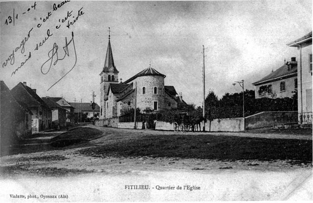

Фитильё
- коммуна во Франции
Hiking in Фитильё
Fitilieu is a charming village located in the Isère department of the Auvergne-Rhône-Alpes region in southeastern France. It’s a fantastic destination for hiking enthusiasts, offering a mix of picturesque landscapes, scenic trails, and opportunities to immerse yourself in nature....
- Страна:
- Почтовый код: 38490
- Координаты: 45° 32' 48" N, 5° 33' 42" E
- GPS треки (wikiloc): [Ссылка]
- Площадь: 10.01 кв.км
- Население: 1905


Граньё
- коммуна во Франции
Hiking in Граньё
Granieu is a charming village nestled in the picturesque French Alps, making it a fantastic destination for hiking enthusiasts. Its location offers access to a variety of trails that cater to different skill levels, from gentle walks to challenging ascents. Here are some highlights for hiking in the Granieu area:...
- Страна:
- Почтовый код: 38490
- Координаты: 45° 35' 58" N, 5° 35' 19" E
- GPS треки (wikiloc): [Ссылка]
- Площадь: 3.73 кв.км
- Население: 482


Корбелен
- коммуна во Франции
Hiking in Корбелен
Corbelin is a charming village located in the Auvergne-Rhône-Alpes region of France, and it offers a variety of outdoor activities, including hiking. The area is known for its scenic landscapes, wooded hills, and proximity to natural reserves, making it an ideal spot for those who enjoy immersing themselves in nature....
- Страна:
- Почтовый код: 38630
- Координаты: 45° 36' 27" N, 5° 32' 41" E
- GPS треки (wikiloc): [Ссылка]
- Площадь: 12 кв.км
- Население: 2223
- Веб сайт: [Ссылка]
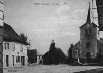

Шимьен
- коммуна во Франции
Hiking in Шимьен
Chimilin might refer to a specific region or area, but it doesn’t appear to be widely recognized as a hiking destination in available resources or discussions up to October 2023. However, if you are referring to a specific place known for hiking, such as Chimilin National Park or another similar-sounding location, please clarify....
- Страна:
- Почтовый код: 38490
- Координаты: 45° 34' 37" N, 5° 35' 58" E
- GPS треки (wikiloc): [Ссылка]
- Площадь: 9.66 кв.км
- Население: 1467
- Веб сайт: [Ссылка]