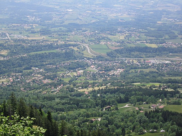
Fillinges (Fillinges)

- коммуна во Франции
 Hiking in Fillinges
Fillinges, located in the Haute-Savoie region of France, is a charming area that offers a variety of hiking opportunities amidst beautiful landscapes. Nestled near the French-Chevalier Mountains and close to Lake Geneva, the region provides stunning views and a mix of terrain suitable for different hiking levels.
Hiking Highlights in Fillinges:
-
Scenic Trails: The area around Fillinges features numerous trails that wind through forests, meadows, and hills. You can enjoy panoramic views of the surrounding mountains and valleys.
-
Nature and Wildlife: The region is rich in biodiversity, making it an excellent spot for nature lovers. Keep an eye out for local flora and fauna, especially during the spring and summer months when the wildflowers bloom.
-
Accessibility: Many trails in Fillinges are accessible for families and beginners, while there are also more challenging routes for seasoned hikers. Make sure to check trail markers and maps for difficulty levels before heading out.
-
Cultural Sites: Incorporating local history into your hike can be rewarding. Look for historical landmarks or viewpoints that offer insights into the region's heritage.
-
Weather Considerations: The weather in the Haute-Savoie region can change rapidly, especially in higher elevations. Always check the local weather forecast before heading out, and prepare accordingly with appropriate clothing and gear.
-
Safety Tips: Bring enough water and snacks, and ensure your phone is charged for emergencies. If you’re hiking alone, let someone know your plans.
-
Guided Tours: For those who prefer a guided experience or want to learn more about the area, look for local hiking guides or organized tours that can offer in-depth knowledge and a safe hiking experience.
Recommended Hikes:
- Le Mont Sion: A moderately challenging hike that offers fantastic views of the Mont Blanc massif.
- Local Ridge Trails: Several trails follow the ridges around Fillinges, providing excellent vantage points for photography and a chance to immerse yourself in the surrounding nature.
Before setting out, be sure to check for any local regulations or trail updates, and enjoy the experience of hiking in this beautiful part of France!
- Страна:

- Почтовый код: 74250
- Координаты: 46° 9' 30" N, 6° 20' 31" E


- GPS треки (wikiloc): [Ссылка]
- Площадь: 11.67 кв.км
- Население: 3350
- Веб сайт: http://www.fillinges.fr
- Википедия английская: wiki(en)
- Википедия национальная: wiki(fr)
- Хранилище Wikidata: Wikidata: Q593779
- Катеория в википедии: [Ссылка]
- код Freebase: [/m/03ntywg]
- код GeoNames: Альт: [6442955]
- номер SIREN: [217401280]
- код BNF: [152743860]
- ID отношения в OpenStreetMap: [108510]
- код муниципалитета INSEE: 74128
Граничит с регионами:


Lucinges
- коммуна во Франции
Hiking in Lucinges
Lucinges is a charming village located in the Haute-Savoie region of France, nestled near the French-Swiss border. It offers stunning views of the surrounding Alpine landscape and is an excellent spot for hiking enthusiasts. Here are some details about hiking in Lucinges:...
- Страна:
- Почтовый код: 74380
- Координаты: 46° 11' 27" N, 6° 19' 7" E
- GPS треки (wikiloc): [Ссылка]
- Площадь: 7.69 кв.км
- Население: 1641
- Веб сайт: [Ссылка]

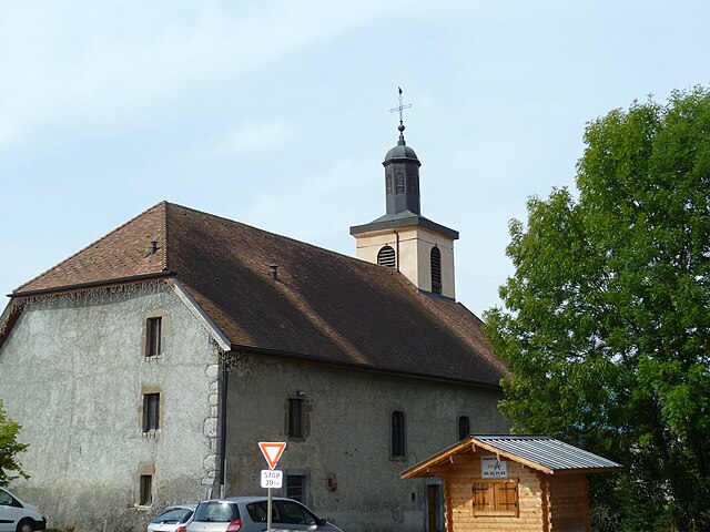
Bonne, Haute-Savoie
- коммуна во Франции
Hiking in Bonne, Haute-Savoie
Hiking in Bonne, Haute-Savoie, offers a fantastic experience for outdoor enthusiasts. Situated in the picturesque region of the French Alps, Bonne is known for its stunning mountainous scenery, with a variety of trails suited for different skill levels, from beginners to advanced hikers....
- Страна:
- Почтовый код: 74380
- Координаты: 46° 10' 6" N, 6° 19' 14" E
- GPS треки (wikiloc): [Ссылка]
- Площадь: 8.58 кв.км
- Население: 3245
- Веб сайт: [Ссылка]

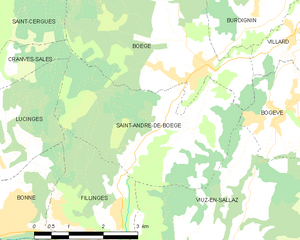
Saint-André-de-Boëge
- коммуна во Франции
Hiking in Saint-André-de-Boëge
Saint-André-de-Boëge is a charming commune located in the Haute-Savoie department in the Auvergne-Rhône-Alpes region of southeastern France. It's nestled within the scenic backdrop of the French Alps, making it an appealing destination for outdoor enthusiasts and hikers....
- Страна:
- Почтовый код: 74420
- Координаты: 46° 11' 25" N, 6° 23' 37" E
- GPS треки (wikiloc): [Ссылка]
- Площадь: 12.6 кв.км
- Население: 549

Nangy
- коммуна во Франции
Hiking in Nangy
Nangy, located in the Haute-Savoie department in the Auvergne-Rhône-Alpes region of France, offers a variety of hiking options that showcase stunning landscapes, charming alpine scenery, and a taste of the local culture....
- Страна:
- Почтовый код: 74380
- Координаты: 46° 9' 15" N, 6° 18' 23" E
- GPS треки (wikiloc): [Ссылка]
- Площадь: 4.35 кв.км
- Население: 1695
- Веб сайт: [Ссылка]

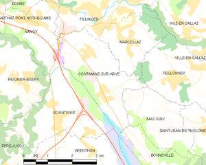
Contamine-sur-Arve
- коммуна во Франции
Hiking in Contamine-sur-Arve
Contamine-sur-Arve is a charming commune located in the Haute-Savoie region of France, near Mont Blanc. It offers a variety of hiking opportunities that cater to different skill levels and preferences. Here are some highlights and tips for hiking in and around Contamine-sur-Arve:...
- Страна:
- Почтовый код: 74130
- Координаты: 46° 7' 42" N, 6° 20' 26" E
- GPS треки (wikiloc): [Ссылка]
- Площадь: 6.92 кв.км
- Население: 1940
- Веб сайт: [Ссылка]


Viuz-en-Sallaz
- коммуна во Франции
Hiking in Viuz-en-Sallaz
Viuz-en-Sallaz, located in the Haute-Savoie region of France, is an ideal destination for hiking enthusiasts. Nestled in the foothills of the Alps, it offers a mix of scenic landscapes, including lush forests, rolling hills, and panoramic mountain views....
- Страна:
- Почтовый код: 74250
- Координаты: 46° 8' 51" N, 6° 24' 37" E
- GPS треки (wikiloc): [Ссылка]
- Площадь: 20.99 кв.км
- Население: 4206


Marcellaz
- коммуна во Франции
Hiking in Marcellaz
Marcellaz is a picturesque area located in the Haute-Savoie region of France, surrounded by the stunning French Alps. It offers a variety of hiking trails that cater to different experience levels, making it a great destination for both novice and experienced hikers....
- Страна:
- Почтовый код: 74250
- Координаты: 46° 8' 40" N, 6° 21' 16" E
- GPS треки (wikiloc): [Ссылка]
- Площадь: 4.17 кв.км
- Население: 967