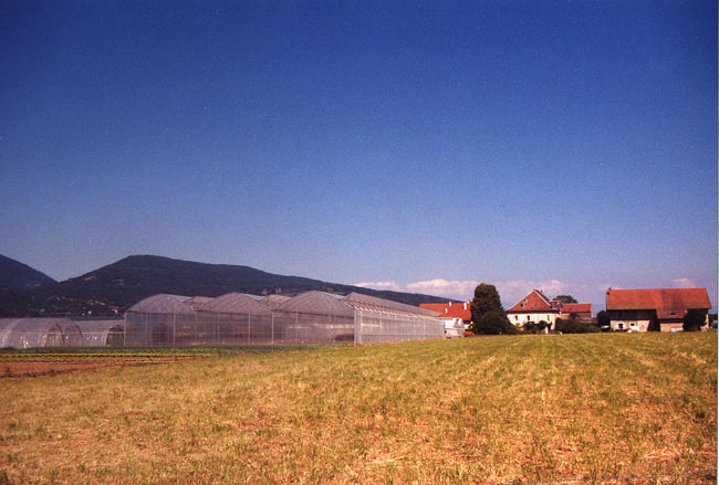
Nangy (Nangy)

- коммуна во Франции
 Hiking in Nangy
Nangy, located in the Haute-Savoie department in the Auvergne-Rhône-Alpes region of France, offers a variety of hiking options that showcase stunning landscapes, charming alpine scenery, and a taste of the local culture.
Key Highlights for Hiking in Nangy:
-
Scenic Views: The area is known for its breathtaking views of the surrounding mountains, including the Mont Blanc massif. Hikers can enjoy panoramic landscapes that change with the seasons.
-
Diverse Trails: Nangy features a range of hiking trails suitable for different skill levels, from leisurely walks to challenging hikes. Trails can take you through lush forests, meadows, and rocky terrains.
-
Local Flora and Fauna: As you hike, you may encounter a variety of local wildlife and plants, making it a great opportunity for nature enthusiasts and photographers alike.
-
Cultural Aspects: The region has historical sites and villages that reflect its cultural heritage. You can incorporate visits to local farms or small towns that offer a glimpse into traditional Savoyard life.
-
Accessibility: Nangy is conveniently located near several cities, making it an accessible destination for day hikes or weekend getaways.
-
Seasonal Considerations: Depending on the time of year, keep in mind that weather conditions can greatly affect trail accessibility. Summer and early fall are typically the most popular times for hiking, while winter may offer opportunities for snowshoeing or skiing.
Recommended Tips for Hiking in Nangy:
- Preparation: Always check trail conditions and weather forecasts before heading out.
- Gear: Wear appropriate hiking gear, including sturdy footwear and layers, as temperatures can vary throughout the day.
- Hydration and Snacks: Carry enough water and snacks to keep your energy up during the hike.
- Navigation: Familiarize yourself with your chosen trails and consider carrying a map or GPS device.
Popular Trails:
While specific trails may vary in Namgy and its surroundings, look for local resources like visitor centers or hiking maps to find routes that best suit your interests and abilities.
Overall, hiking in Nangy can be a rewarding experience with the chance to immerse yourself in the natural beauty and culture of the French Alps.
- Страна:

- Почтовый код: 74380
- Координаты: 46° 9' 15" N, 6° 18' 23" E


- GPS треки (wikiloc): [Ссылка]
- Площадь: 4.35 кв.км
- Население: 1695
- Веб сайт: http://www.mairienangy.fr
- Википедия английская: wiki(en)
- Википедия национальная: wiki(fr)
- Хранилище Wikidata: Wikidata: Q684186
- Катеория в википедии: [Ссылка]
- код Freebase: [/m/03ntzsp]
- код GeoNames: Альт: [6443010]
- номер SIREN: [217401975]
- код BNF: [152744550]
- код муниципалитета INSEE: 74197
Граничит с регионами:


Reignier-Esery
- коммуна во Франции
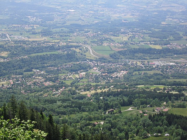
Hiking in Reignier-Esery
Reignier-Ésery is a charming commune located in the Haute-Savoie region of France, nestled between the city of Annecy and the French Alps. The area offers a variety of hiking opportunities, perfect for both beginners and experienced hikers. Here are some details and tips for hiking in and around Reignier-Ésery:...
- Страна:
- Почтовый код: 74930
- Координаты: 46° 8' 4" N, 6° 16' 6" E
- GPS треки (wikiloc): [Ссылка]
- Площадь: 25.08 кв.км
- Население: 7585
- Веб сайт: [Ссылка]

Arthaz-Pont-Notre-Dame
- коммуна во Франции
Hiking in Arthaz-Pont-Notre-Dame
Arthaz-Pont-Notre-Dame is a small commune located in the Haute-Savoie department in the Auvergne-Rhône-Alpes region of southeastern France. While it may not be as widely known as some of the larger tourist destinations in the Alps, it offers some charming hiking opportunities in a picturesque setting....
- Страна:
- Почтовый код: 74380
- Координаты: 46° 9' 32" N, 6° 16' 1" E
- GPS треки (wikiloc): [Ссылка]
- Площадь: 5.96 кв.км
- Население: 1440
- Веб сайт: [Ссылка]


Fillinges
- коммуна во Франции
Hiking in Fillinges
Fillinges, located in the Haute-Savoie region of France, is a charming area that offers a variety of hiking opportunities amidst beautiful landscapes. Nestled near the French-Chevalier Mountains and close to Lake Geneva, the region provides stunning views and a mix of terrain suitable for different hiking levels....
- Страна:
- Почтовый код: 74250
- Координаты: 46° 9' 30" N, 6° 20' 31" E
- GPS треки (wikiloc): [Ссылка]
- Площадь: 11.67 кв.км
- Население: 3350
- Веб сайт: [Ссылка]

Bonne, Haute-Savoie
- коммуна во Франции
Hiking in Bonne, Haute-Savoie
Hiking in Bonne, Haute-Savoie, offers a fantastic experience for outdoor enthusiasts. Situated in the picturesque region of the French Alps, Bonne is known for its stunning mountainous scenery, with a variety of trails suited for different skill levels, from beginners to advanced hikers....
- Страна:
- Почтовый код: 74380
- Координаты: 46° 10' 6" N, 6° 19' 14" E
- GPS треки (wikiloc): [Ссылка]
- Площадь: 8.58 кв.км
- Население: 3245
- Веб сайт: [Ссылка]

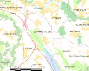
Contamine-sur-Arve
- коммуна во Франции
Hiking in Contamine-sur-Arve
Contamine-sur-Arve is a charming commune located in the Haute-Savoie region of France, near Mont Blanc. It offers a variety of hiking opportunities that cater to different skill levels and preferences. Here are some highlights and tips for hiking in and around Contamine-sur-Arve:...
- Страна:
- Почтовый код: 74130
- Координаты: 46° 7' 42" N, 6° 20' 26" E
- GPS треки (wikiloc): [Ссылка]
- Площадь: 6.92 кв.км
- Население: 1940
- Веб сайт: [Ссылка]


Scientrier
- коммуна во Франции
Hiking in Scientrier
Scientrier is a commune located in the Haute-Savoie department in the Auvergne-Rhône-Alpes region of southeastern France, near Lake Geneva. While it may not be as widely known as other hiking destinations in the region, it offers a variety of outdoor activities and trails that can appeal to hikers of all levels....
- Страна:
- Почтовый код: 74930
- Координаты: 46° 7' 8" N, 6° 18' 56" E
- GPS треки (wikiloc): [Ссылка]
- Площадь: 7.21 кв.км
- Население: 1156