Фитильё (Fitilieu, Fitilieu)

- коммуна во Франции
 Hiking in Фитильё
Fitilieu is a charming village located in the Isère department of the Auvergne-Rhône-Alpes region in southeastern France. It’s a fantastic destination for hiking enthusiasts, offering a mix of picturesque landscapes, scenic trails, and opportunities to immerse yourself in nature.
Hiking Trails
-
Local Trails: The region around Fitilieu has a variety of well-marked local hiking trails suitable for different skill levels. You can find paths that meander through forests, past streams, and over hills that provide rewarding views.
-
The Chartreuse Mountains: Just a short distance from Fitilieu, the Chartreuse Mountains offer more challenging hikes with beautiful vistas. Popular hikes include routes to the Dent de Crolles or the Grand Som, each promising stunning panoramas and a taste of the region's rugged terrain.
-
La Verne: There are also trails leading towards La Verne, where hikers can appreciate the natural beauty and wildlife of the area.
Tips for Hiking in Fitilieu
- Weather: Always check the weather before heading out, as conditions can change rapidly in the mountains.
- Footwear: Wear appropriate hiking boots or shoes with good traction since some trails can be rocky or steep.
- Safety: Carry enough water, snacks, a map or GPS device, and let someone know your hiking plans.
- Local Guides: For a more in-depth experience, consider hiring a local guide who can provide valuable insights into the local flora, fauna, and history.
Nearby Attractions
After a day of hiking, you can explore the quaint village of Fitilieu, check out local eateries, or venture to nearby towns such as La Tour-du-Pin for additional dining and cultural experiences.
Whether you’re seeking a leisurely walk or a fulfilling day hike, Fitilieu and its surrounding areas can cater to a variety of hiking preferences. Enjoy your adventure!
- Страна:

- Почтовый код: 38490
- Координаты: 45° 32' 48" N, 5° 33' 42" E


- GPS треки (wikiloc): [Ссылка]
- Площадь: 10.01 кв.км
- Население: 1905
- Википедия русская: wiki(ru)
- Википедия английская: wiki(en)
- Википедия национальная: wiki(fr)
- Хранилище Wikidata: Wikidata: Q1069501
- Катеория в википедии: [Ссылка]
- код Freebase: [/m/03nvjv3]
- код Freebase: [/m/03nvjv3]
- код GeoNames: Альт: [6433199]
- код GeoNames: Альт: [6433199]
- код BNF: [15257986z]
- код BNF: [15257986z]
- код муниципалитета INSEE: 38165
- код муниципалитета INSEE: 38165
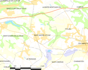
Граничит с регионами:

Сент-Андре-ле-Газ
- коммуна во Франции
Hiking in Сент-Андре-ле-Газ
Saint-André-le-Gaz, located in the Auvergne-Rhône-Alpes region of France, offers a delightful experience for hikers and outdoor enthusiasts. Nestled at the foothills of the Chartreuse Mountains and near the Rhône Valley, this area provides a range of trails suitable for various skill levels, from leisurely walks to more challenging hikes....
- Страна:
- Почтовый код: 38490
- Координаты: 45° 32' 56" N, 5° 32' 3" E
- GPS треки (wikiloc): [Ссылка]
- Площадь: 8.89 кв.км
- Население: 2783
- Веб сайт: [Ссылка]


Ла-Бати-Монгаскон
- коммуна во Франции
Hiking in Ла-Бати-Монгаскон
La Bâtie-Montgascon is a charming village located in the Auvergne-Rhône-Alpes region of France, near the foothills of the Alps. The area is rich with natural beauty and offers various hiking opportunities for outdoor enthusiasts....
- Страна:
- Почтовый код: 38110
- Координаты: 45° 34' 45" N, 5° 31' 41" E
- GPS треки (wikiloc): [Ссылка]
- Площадь: 8.43 кв.км
- Население: 1890
- Веб сайт: [Ссылка]
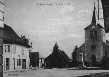

Шимьен
- коммуна во Франции
Hiking in Шимьен
Chimilin might refer to a specific region or area, but it doesn’t appear to be widely recognized as a hiking destination in available resources or discussions up to October 2023. However, if you are referring to a specific place known for hiking, such as Chimilin National Park or another similar-sounding location, please clarify....
- Страна:
- Почтовый код: 38490
- Координаты: 45° 34' 37" N, 5° 35' 58" E
- GPS треки (wikiloc): [Ссылка]
- Площадь: 9.66 кв.км
- Население: 1467
- Веб сайт: [Ссылка]