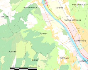
Фонтаний-Корнийон (Fontanil-Cornillon, Fontanil-Cornillon)

- коммуна во Франции
 Hiking in Фонтаний-Корнийон
Fontanil-Cornillon, located near Grenoble in the Auvergne-Rhône-Alpes region of France, offers a variety of hiking opportunities for outdoor enthusiasts. The area is characterized by its beautiful landscapes, charming villages, and proximity to the Chartreuse Mountains and the Vercors Regional Natural Park.
Hiking Highlights:
-
Scenic Views: The trails in Fontanil-Cornillon often provide stunning panoramic views of the surrounding mountains, valleys, and the city of Grenoble below. Lookouts along the trails can be excellent spots for photography and taking in the scenery.
-
Diverse Trails: You can find trails ranging from easy walks suitable for families to more challenging hikes for seasoned hikers. Popular routes might include paths through forests, meadows, and rocky terrain, with varying difficulty levels.
-
Access to the Vercors: Fontanil-Cornillon serves as a gateway to the Vercors Massif, a popular area for hiking. Many trails are accessible from the town or a short drive away, leading to remarkable natural sites and offering opportunities for wildlife watching.
-
Historical and Cultural Sites: While hiking, you may encounter historical remnants, such as old farms, churches, and other cultural landmarks, adding an educational aspect to your outdoor adventure.
-
Flora and Fauna: The region is home to diverse ecosystems, so be on the lookout for various plant species and local wildlife, including birds and small mammals.
Tips for Hiking in Fontanil-Cornillon:
- Check Weather Conditions: Always inquire about the weather forecast before heading out, as conditions can change rapidly in mountainous areas.
- Start Early: To make the most of your day, consider starting your hike early, especially if you plan on covering longer distances.
- Stay Hydrated and Pack Snacks: Bring plenty of water and energy-rich snacks to keep your energy up throughout your hike.
- Respect Nature: Follow Leave No Trace principles to preserve the natural beauty of the area. Stick to marked trails and dispose of waste properly.
Conclusion:
Fontanil-Cornillon is a beautiful area for hiking, offering a mix of natural beauty, outdoor adventure, and cultural experiences. Whether you're a beginner or a seasoned hiker, you'll find trails that suit your skill level and provide a memorable experience. Always consult local trail maps and information for the best routes and safety guidelines before setting out. Happy hiking!
- Страна:

- Почтовый код: 38120
- Координаты: 45° 15' 20" N, 5° 39' 55" E


- GPS треки (wikiloc): [Ссылка]
- Площадь: 5.5 кв.км
- Население: 2735
- Веб сайт: http://www.ville-fontanil.fr
- Википедия русская: wiki(ru)
- Википедия английская: wiki(en)
- Википедия национальная: wiki(fr)
- Хранилище Wikidata: Wikidata: Q596028
- Катеория в википедии: [Ссылка]
- код Freebase: [/m/03g_58h]
- код GeoNames: Альт: [6433201]
- номер SIREN: [213801707]
- код BNF: [152579906]
- место в MusicBrainz: [d1a49344-b751-4137-82cf-aa4222fcfbd1]
- код муниципалитета INSEE: 38170
Граничит с регионами:


Сент-Эгрев
- коммуна во Франции
Hiking in Сент-Эгрев
Saint-Égrève is a commune located in the Isère department in the Auvergne-Rhône-Alpes region of southeastern France, close to the city of Grenoble. It offers a variety of hiking opportunities for outdoor enthusiasts, particularly due to its proximity to the breathtaking Chartreuse and Vercors mountains....
- Страна:
- Почтовый код: 38120
- Координаты: 45° 13' 54" N, 5° 40' 59" E
- GPS треки (wikiloc): [Ссылка]
- Высота над уровнем моря: 202 м m
- Площадь: 10.88 кв.км
- Население: 15738
- Веб сайт: [Ссылка]

Нуайаре
- коммуна во Франции
Hiking in Нуайаре
Noyarey is a charming commune located in the Auvergne-Rhône-Alpes region of France, near the city of Saint-Egrève and the beautiful landscape of the Chartreuse Mountains. Hiking in Noyarey and its surrounding areas offers a variety of trails with stunning views of the mountains and valleys. Here are some key points to consider when hiking in Noyarey:...
- Страна:
- Почтовый код: 38360
- Координаты: 45° 14' 37" N, 5° 37' 53" E
- GPS треки (wikiloc): [Ссылка]
- Площадь: 16.86 кв.км
- Население: 2257
- Веб сайт: [Ссылка]


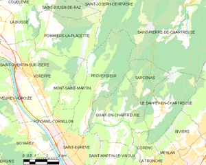
Мон-Сен-Мартен
- коммуна - Рона — Альпы, Изер, Гренобль
Hiking in Мон-Сен-Мартен
Mont-Saint-Martin, located in the Isère department of the Auvergne-Rhône-Alpes region in southeastern France, offers a variety of hiking opportunities that showcase the beautiful landscapes and natural features of the Alps. Here are some highlights and tips for hiking in the area:...
- Страна:
- Почтовый код: 38120
- Координаты: 45° 16' 17" N, 5° 40' 31" E
- GPS треки (wikiloc): [Ссылка]
- Площадь: 5.31 кв.км
- Население: 80

Провезьё
- коммуна во Франции
Hiking in Провезьё
Proveysieux is a charming village located in the Grenoble area of the French Alps. It's a fantastic destination for hiking enthusiasts looking to explore the natural beauty of the region. Here are some key points about hiking in Proveysieux:...
- Страна:
- Почтовый код: 38120
- Координаты: 45° 15' 46" N, 5° 41' 58" E
- GPS треки (wikiloc): [Ссылка]
- Площадь: 20.37 кв.км
- Население: 503


Вореп
- коммуна во Франции
Hiking in Вореп
Voreppe, located in the Isère department of southeastern France, is a picturesque area that offers various hiking opportunities amid stunning natural landscapes. The proximity to the Chartreuse and Vercors mountain ranges makes it an ideal base for outdoor enthusiasts....
- Страна:
- Почтовый код: 38340
- Координаты: 45° 17' 52" N, 5° 38' 13" E
- GPS треки (wikiloc): [Ссылка]
- Площадь: 28.65 кв.км
- Население: 9441
- Веб сайт: [Ссылка]