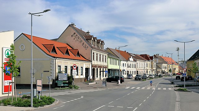
Хохлайтен (Hochleithen, Hochleithen)
 Hiking in Хохлайтен
Hochleithen is a picturesque area that offers various hiking opportunities, nestled in the scenic landscapes of Austria. Here’s a brief overview for anyone considering a hiking trip in Hochleithen:
Trails and Routes
- Scenic Views: Many trails in Hochleithen provide stunning vistas of the surrounding hills and valleys. Look for routes that lead to viewpoints or peaks for rewarding panoramas.
- Difficulty Levels: There are trails suitable for all skill levels. Beginners might enjoy shorter, less challenging paths, while experienced hikers can explore more strenuous routes.
- Marked Trails: Most hiking routes are well-marked, making it easier to navigate. Always check local maps or guides for trail conditions and proper markings.
Flora and Fauna
- Biodiversity: The area is rich in biodiversity. You might spot various wildlife, including deer and numerous bird species, as well as unique alpine flora.
- Floral Seasons: Consider the time of year you visit, as spring and summer will showcase wildflowers in bloom, while autumn brings vibrant fall colors.
Preparation
- Gear: Wear sturdy hiking boots and dress in layers; weather can change quickly in mountainous regions. A waterproof jacket is advisable.
- Supplies: Bring enough water, snacks, and a first-aid kit. It's also wise to carry a map and a fully charged phone for navigation.
Safety Tips
- Stay on Trails: Protect the environment by staying on designated paths.
- Be Aware of Weather Conditions: Always check the weather before heading out, and be prepared for sudden changes.
- Inform Someone: Let someone know your plans, including your expected return time.
Local Regulations
- Respect Nature: Follow Leave No Trace principles to help preserve the natural beauty of the area.
- Wildfire Precautions: If hiking during dry seasons, be aware of fire regulations and avoid actions that could ignite a fire.
Nearby Attractions
- After a day of hiking, consider exploring local villages, tasting regional cuisine, or visiting cultural sites to enrich your experience.
In summary, hiking in Hochleithen can be a remarkable experience filled with beautiful scenery and the tranquility of nature. Always prepare well and embrace the adventure!
- Страна:

- Почтовый код: 2123
- Телефонный код: 02245
- Код автомобильного номера: MI
- Координаты: 48° 27' 0" N, 16° 31' 0" E


- GPS треки (wikiloc): [Ссылка]
- Высота над уровнем моря: 226 м m
- Площадь: 19.91 кв.км
- Население: 1166
- Веб сайт: http://www.hochleithen.at/
- Википедия русская: wiki(ru)
- Википедия английская: wiki(en)
- Википедия национальная: wiki(de)
- Хранилище Wikidata: Wikidata: Q665986
- Катеория в википедии: [Ссылка]
- код Freebase: [/m/02qyhd0]
- код GeoNames: Альт: [3333673]
- код VIAF: Альт: [240113964]
- код GND: Альт: [4799956-1]
- код австрийского муниципалитета: [31622]
Граничит с регионами:

Кройталь
Hiking in Кройталь
Kreuttal is a picturesque valley located in Austria, known for its stunning landscapes, diverse flora and fauna, and well-marked hiking trails. If you're considering a hiking trip in Kreuttal, here are some key points to keep in mind:...
- Страна:
- Почтовый код: 2123
- Телефонный код: 02245
- Код автомобильного номера: MI
- Координаты: 48° 26' 0" N, 16° 29' 0" E
- GPS треки (wikiloc): [Ссылка]
- Высота над уровнем моря: 207 м m
- Площадь: 21.51 кв.км
- Население: 1429
- Веб сайт: [Ссылка]

Кройцштеттен
Hiking in Кройцштеттен
Kreuzstetten, located in Austria, offers a variety of scenic hiking opportunities for outdoor enthusiasts. While the area itself may not be as widely known as some of the alpine regions, it is surrounded by beautiful landscapes that provide a peaceful environment for hiking....
- Страна:
- Почтовый код: 2124
- Телефонный код: 02263
- Код автомобильного номера: MI
- Координаты: 48° 28' 0" N, 16° 28' 0" E
- GPS треки (wikiloc): [Ссылка]
- Высота над уровнем моря: 224 м m
- Площадь: 24.33 кв.км
- Население: 1541
- Веб сайт: [Ссылка]

Ульрикскирхен-Шлайнбах
Hiking in Ульрикскирхен-Шлайнбах
Ulrichskirchen-Schleinbach, located in Austria, is a charming area characterized by rolling hills, lush landscapes, and scenic views. While it might not be the most famous hiking destination, it offers several opportunities for hiking enthusiasts to explore the natural beauty of the region....
- Страна:
- Почтовый код: 2122
- Телефонный код: 02245
- Код автомобильного номера: MI
- Координаты: 48° 24' 3" N, 16° 29' 28" E
- GPS треки (wikiloc): [Ссылка]
- Высота над уровнем моря: 192 м m
- Площадь: 26.52 кв.км
- Население: 2630
- Веб сайт: [Ссылка]
Гавайнсталь
Hiking in Гавайнсталь
Gaweinstal is a small village located in the Lower Austria region of Austria, known for its beautiful landscapes and proximity to the natural beauty of the country. While not a major hiking destination like some larger national parks or mountainous areas, Gaweinstal offers several opportunities for outdoor enthusiasts to explore the surrounding countryside. Here’s what you can expect when hiking in this area:...
- Страна:
- Почтовый код: 2191
- Телефонный код: 02574
- Код автомобильного номера: MI
- Координаты: 48° 28' 41" N, 16° 35' 21" E
- GPS треки (wikiloc): [Ссылка]
- Высота над уровнем моря: 199 м m
- Площадь: 51.71 кв.км
- Население: 3947
- Веб сайт: [Ссылка]

Бад-Пираварт
Hiking in Бад-Пираварт
Bad Pirawarth, located in the northeastern part of Austria, is a quaint village known for its scenic landscapes and outdoor activities, including hiking. The region offers a mix of extensive trails that cater to various skill levels, making it a great destination for both novice and experienced hikers....
- Страна:
- Почтовый код: 2222
- Телефонный код: 02574
- Код автомобильного номера: GF
- Координаты: 48° 27' 7" N, 16° 35' 57" E
- GPS треки (wikiloc): [Ссылка]
- Высота над уровнем моря: 177 м m
- Площадь: 25.42 кв.км
- Население: 1671
- Веб сайт: [Ссылка]
Волькерсдорф-им-Вайнфиртель
Hiking in Волькерсдорф-им-Вайнфиртель
Wolkersdorf im Weinviertel, located in the Lower Austria region, offers several charming hiking opportunities that showcase the beautiful landscapes of the Weinviertel wine region. Here are some key highlights and tips for hiking in this area:...
- Страна:
- Почтовый код: 2120
- Телефонный код: 02245
- Код автомобильного номера: MI
- Координаты: 48° 22' 0" N, 16° 31' 0" E
- GPS треки (wikiloc): [Ссылка]
- Высота над уровнем моря: 178 м m
- Площадь: 44.38 кв.км
- Население: 7201
- Веб сайт: [Ссылка]