Hauterives (Hauterives)

- коммуна во Франции
 Hiking in Hauterives
Hauterives is a charming village located in the Drôme department of southeastern France, known for its scenic landscapes and rich cultural heritage. While it might not be as well-known as some major hiking destinations, it offers several opportunities for those looking to explore nature and enjoy the outdoors.
Hiking Trails
-
Local Trails: Hauterives has a variety of local trails that wind through the surrounding countryside. These trails can include flat paths alongside fields and forests, making them accessible for hikers of all levels.
-
Tour de la Vallée de la Bourne: A popular route in the nearby region, this trail offers stunning views of the Vercors mountains and the Bourne River, making it a picturesque option for a day hike.
-
Cultural Walks: In addition to pure hiking, you can combine walking with cultural exploration. The village is home to the well-known Palais Idéal, an architectural marvel created by Ferdinand Cheval. Walking to and from this site can be a great way to incorporate history into your hike.
Best Time to Hike
The ideal times for hiking in Hauterives are spring (April to June) and autumn (September to November) when the weather is mild. Summers can be hot, so early morning hikes or those shaded by trees are recommended.
Tips for Hikers
- Maps and Guides: Make sure to have a good map of the local trails. While many paths are well-marked, having a map can help you explore more remote areas.
- Local Advice: Check in with local tourism offices for the latest information on trails and conditions.
- Equipment: Wear appropriate footwear and carry plenty of water, especially during warmer months.
- Respect Nature: Follow Leave No Trace principles to preserve the natural beauty of the area.
Nearby Attractions
If you're planning a hiking trip to Hauterives, consider combining it with visits to nearby towns or parks, such as the Vercors Regional Natural Park, which is a short drive away and offers more extensive hiking opportunities.
Overall, hiking in Hauterives provides a unique blend of natural beauty and cultural experiences, making it a delightful destination for outdoor enthusiasts. Enjoy your adventure!
- Страна:

- Почтовый код: 26390
- Координаты: 45° 15' 20" N, 5° 1' 35" E


- GPS треки (wikiloc): [Ссылка]
- Площадь: 30.51 кв.км
- Население: 1904
- Википедия английская: wiki(en)
- Википедия национальная: wiki(fr)
- Хранилище Wikidata: Wikidata: Q477755
- Катеория в википедии: [Ссылка]
- код Freebase: [/m/03mhgns]
- код GeoNames: Альт: [3013742]
- номер SIREN: [212601488]
- код BNF: [152530092]
- код VIAF: Альт: [136057588]
- ID отношения в OpenStreetMap: [49636]
- идентификатор местоположения ArchINFORM: [16050]
- код LCNAF: Альт: [n81151138]
- код муниципалитета INSEE: 26148
Граничит с регионами:


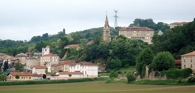
Saint-Christophe-et-le-Laris
- коммуна во Франции
Hiking in Saint-Christophe-et-le-Laris
Saint-Christophe-et-le-Laris is a picturesque commune located in the Drôme department in southeastern France. While it may not be as widely known as some larger hiking areas, it offers beautiful landscapes and opportunities for outdoor activities in a serene environment....
- Страна:
- Почтовый код: 26350
- Координаты: 45° 12' 36" N, 5° 4' 19" E
- GPS треки (wikiloc): [Ссылка]
- Площадь: 11.35 кв.км
- Население: 413


Лантиоль
- коммуна во Франции
Hiking in Лантиоль
Lentiol, a beautiful area in the French Alps, is a fantastic destination for hiking enthusiasts. Here are a few key points about hiking in Lentiol:...
- Страна:
- Почтовый код: 38270
- Координаты: 45° 17' 57" N, 5° 6' 48" E
- GPS треки (wikiloc): [Ссылка]
- Площадь: 7.6 кв.км
- Население: 217


Saint-Sorlin-en-Valloire
- коммуна во Франции
Hiking in Saint-Sorlin-en-Valloire
Saint-Sorlin-en-Valloire is a picturesque village located in the French Alps, known for its stunning natural beauty and an array of outdoor activities, especially hiking. Here are some highlights and tips for hiking in this beautiful area:...
- Страна:
- Почтовый код: 26210
- Координаты: 45° 17' 21" N, 4° 57' 5" E
- GPS треки (wikiloc): [Ссылка]
- Площадь: 26.5 кв.км
- Население: 2233


Saint-Martin-d'Août
- коммуна во Франции
Hiking in Saint-Martin-d'Août
Saint-Martin-d'Août is a beautiful location for hiking enthusiasts, situated in the Rhône-Alpes region of France. This village is surrounded by the stunning natural landscapes of the Vercors and the Drôme Provençale, offering a variety of hiking trails that cater to different skill levels....
- Страна:
- Почтовый код: 26330
- Координаты: 45° 13' 3" N, 4° 59' 5" E
- GPS треки (wikiloc): [Ссылка]
- Площадь: 7.67 кв.км
- Население: 381

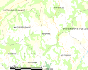
Tersanne
- коммуна во Франции
Hiking in Tersanne
Tersanne is a picturesque region in the French Alps, known for its stunning landscapes, diverse wildlife, and a variety of hiking trails catering to different skill levels. Hiking in this area offers a unique opportunity to experience the natural beauty of the Alps, from lush valleys and meandering rivers to towering mountain peaks....
- Страна:
- Почтовый код: 26390
- Координаты: 45° 13' 34" N, 5° 1' 2" E
- GPS треки (wikiloc): [Ссылка]
- Площадь: 9.49 кв.км
- Население: 359


Lens-Lestang
- коммуна во Франции
Hiking in Lens-Lestang
Lens-Lestang is a charming commune located in the Drôme department of southeastern France. It offers a wonderful opportunity for hiking enthusiasts to explore scenic landscapes, picturesque villages, and diverse ecosystems. Here are some key points to consider when planning a hike in and around Lens-Lestang:...
- Страна:
- Почтовый код: 26210
- Координаты: 45° 17' 30" N, 5° 2' 33" E
- GPS треки (wikiloc): [Ссылка]
- Площадь: 16.41 кв.км
- Население: 837
- Веб сайт: [Ссылка]


Moras-en-Valloire
- коммуна во Франции
Hiking in Moras-en-Valloire
Moras-en-Valloire, located in the Auvergne-Rhône-Alpes region of France, offers a beautiful setting for hiking enthusiasts. The area is known for its picturesque landscapes, rolling hills, and scenic views typical of the Rhône valley....
- Страна:
- Почтовый код: 26210
- Координаты: 45° 17' 25" N, 4° 59' 36" E
- GPS треки (wikiloc): [Ссылка]
- Площадь: 8.58 кв.км
- Население: 646
- Веб сайт: [Ссылка]

Châteauneuf-de-Galaure
- коммуна во Франции
Hiking in Châteauneuf-de-Galaure
Châteauneuf-de-Galaure is a charming village located in the Auvergne-Rhône-Alpes region of France, known for its picturesque landscapes and access to hiking trails. Here are some points of interest for hiking in and around Châteauneuf-de-Galaure:...
- Страна:
- Почтовый код: 26330
- Координаты: 45° 13' 55" N, 4° 57' 25" E
- GPS треки (wikiloc): [Ссылка]
- Площадь: 18.08 кв.км
- Население: 1770


Le Grand-Serre
- коммуна во Франции
Hiking in Le Grand-Serre
Le Grand-Serre is a beautiful hiking destination located in the French Alps, specifically in the department of Isère. This area offers stunning mountain scenery, diverse wildlife, and a variety of trails suitable for different skill levels. Here are some key points to consider when planning a hike in Le Grand-Serre:...
- Страна:
- Почтовый код: 26530
- Координаты: 45° 16' 12" N, 5° 6' 12" E
- GPS треки (wikiloc): [Ссылка]
- Площадь: 24.74 кв.км
- Население: 902