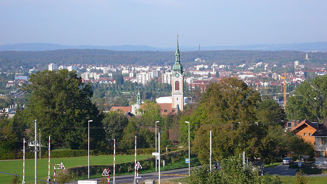
Кройцлинген (Kreuzlingen District, Bezirk Kreuzlingen)

 Hiking in Кройцлинген
Kreuzlingen District, located in the canton of Thurgau in Switzerland, offers a variety of scenic hiking opportunities, especially due to its proximity to the beautiful Lake Constance (Bodensee) and the surrounding natural landscapes. Here are some highlights of hiking in the area:
Trails and Routes
-
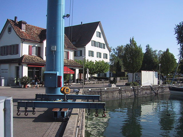
Lake Constance Promenade: A popular hiking and walking route along the shores of Lake Constance. It features beautiful views of the lake, the Alps in the distance, and various parks and gardens. The promenade is great for leisurely strolls or more invigorating walks.
-
Kreuzlingen to Constance: This route connects Kreuzlingen with the city of Constance across the border in Germany. It’s an easy walk that offers pleasant views of the lake, interesting historical sites, and access to charming cafés along the way.
-
Thurgau Hiking Trail: This long-distance hiking trail passes through the Thurgau region. Parts of the trail can be accessed from Kreuzlingen and offer picturesque landscapes, vineyards, and rolling hills.
-
Nature Reserves: The region is home to several nature reserves where you can find well-marked trails. For example, the Untersee offers opportunities to explore its wetlands and enjoy birdwatching.
Things to Consider
-
Difficulty Levels: The hikes in and around Kreuzlingen are generally suitable for all fitness levels. There are easy coastal paths as well as more challenging routes in the nearby hills.
-
Seasonality: Depending on the time of year, you can experience beautiful wildflowers in spring, vibrant autumn foliage, and winter hiking opportunities in nearby elevations.
-
Accommodations and Facilities: The area is equipped with various facilities including restrooms and picnic areas. You may also find refreshments in local restaurants and cafés in Kreuzlingen and Constance.
-
Public Transport: Kreuzlingen is well-connected by public transport, making it easy to reach trailheads or nearby towns.
Safety and Preparation
- Always check the weather conditions before heading out.
- Bring adequate water, snacks, and wear good hiking shoes.
- Familiarize yourself with the trail maps and follow the marked paths.
Overall, hiking in the Kreuzlingen District provides a delightful experience for nature lovers and those looking to explore the scenic beauty of this picturesque Swiss region. Whether you prefer a leisurely walk or a more rigorous hike, the area has something to offer everyone.
- Страна:

- Столица: Кройцлинген
- Код автомобильного номера: TG
- Координаты: 47° 38' 0" N, 9° 10' 0" E


- GPS треки (wikiloc): [Ссылка]
- Высота над уровнем моря: 511 м m
- Площадь: 129 кв.км
- Википедия русская: wiki(ru)
- Википедия английская: wiki(en)
- Википедия национальная: wiki(de)
- Хранилище Wikidata: Wikidata: Q660450
- Катеория в википедии: [Ссылка]
- код Freebase: [/m/0g3xl4]
- код GeoNames: Альт: [8260146]
- идентификатор местоположения ArchINFORM: [5893]
Включает регионы:

Кройцлинген
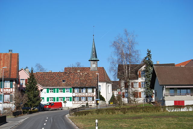
Hiking in Кройцлинген
Kreuzlingen is a quaint town located on the shores of Lake Constance in Switzerland, near the borders of Germany. It's a great starting point for various hiking adventures, as it boasts beautiful landscapes, lakeside paths, and access to regional trails....
- Страна:
- Почтовый код: 8280
- Телефонный код: 071
- Код автомобильного номера: TG
- Координаты: 47° 38' 45" N, 9° 10' 42" E
- GPS треки (wikiloc): [Ссылка]
- Высота над уровнем моря: 397 м m
- Площадь: 11.49 кв.км
- Население: 21801
- Веб сайт: [Ссылка]


Эрматинген
Hiking in Эрматинген
Ermatingen is a charming village located on the shores of Lake Constance in Switzerland, offering beautiful landscapes and a range of hiking opportunities. Hiking in this area can provide you with scenic views, peaceful lakeside paths, and access to the surrounding hills and vineyards....
- Страна:
- Почтовый код: 8272
- Телефонный код: 071
- Код автомобильного номера: TG
- Координаты: 47° 40' 9" N, 9° 4' 47" E
- GPS треки (wikiloc): [Ссылка]
- Высота над уровнем моря: 517 м m
- Площадь: 10.4 кв.км
- Население: 3378
- Веб сайт: [Ссылка]

Раперсвилен
Hiking in Раперсвилен
Raperswilen, a quaint village near the borders of Switzerland and Germany, is a lovely starting point for various hiking adventures. Surrounded by picturesque landscapes typical of the Swiss countryside, it offers a unique blend of nature, culture, and panoramic views....
- Страна:
- Почтовый код: 8558
- Телефонный код: 052
- Код автомобильного номера: TG
- Координаты: 47° 37' 57" N, 9° 2' 34" E
- GPS треки (wikiloc): [Ссылка]
- Высота над уровнем моря: 582 м m
- Площадь: 7.7 кв.км
- Население: 394
- Веб сайт: [Ссылка]


Кемменталь
Hiking in Кемменталь
Kemmental, located in the canton of Thurgau in Switzerland, offers a beautiful setting for hiking enthusiasts. The region is characterized by rolling hills, lush landscapes, and picturesque villages, making it ideal for both leisurely walks and more challenging hikes....
- Страна:
- Почтовый код: 8573
- Телефонный код: 071
- Код автомобильного номера: TG
- Координаты: 47° 36' 59" N, 9° 9' 59" E
- GPS треки (wikiloc): [Ссылка]
- Высота над уровнем моря: 548 м m
- Площадь: 28.4 кв.км
- Население: 2494
- Веб сайт: [Ссылка]

Боттигхофен
Hiking in Боттигхофен
Bottighofen, located on the shores of Lake Constance in Switzerland, offers a variety of hiking opportunities that allow you to enjoy the beautiful landscapes, scenic views, and charming villages in the region. Here are some highlights of hiking in Bottighofen:...
- Страна:
- Телефонный код: 071
- Код автомобильного номера: TG
- Координаты: 47° 38' 0" N, 9° 12' 36" E
- GPS треки (wikiloc): [Ссылка]
- Высота над уровнем моря: 430 м m
- Площадь: 2.4 кв.км
- Население: 2170
- Веб сайт: [Ссылка]


Вельди
Hiking in Вельди
Wäldli (often spelled Wäldi) is a beautiful hiking destination that offers a variety of trails suited to different skill levels. Nestled in the surroundings of natural landscapes, Wäldi usually features lush forests, calming streams, and scenic viewpoints, making it an ideal spot for both novice and experienced hikers....
- Страна:
- Почтовый код: 8564
- Телефонный код: 071
- Код автомобильного номера: TG
- Координаты: 47° 37' 28" N, 9° 4' 57" E
- GPS треки (wikiloc): [Ссылка]
- Высота над уровнем моря: 553 м m
- Площадь: 12.3 кв.км
- Население: 1048
- Веб сайт: [Ссылка]


Тегервилен
Hiking in Тегервилен
Tägerwilen is a beautiful location in Switzerland, situated near Lake Constance. It offers a variety of hiking opportunities for both beginners and experienced hikers. Here are some key features and suggestions for hiking in and around Tägerwilen:...
- Страна:
- Почтовый код: 8274
- Телефонный код: 071
- Код автомобильного номера: TG
- Координаты: 47° 38' 52" N, 9° 7' 56" E
- GPS треки (wikiloc): [Ссылка]
- Высота над уровнем моря: 475 м m
- Площадь: 11.58 кв.км
- Население: 4617
- Веб сайт: [Ссылка]
Ленгвиль
Hiking in Ленгвиль
Lengwil is a charming village located in Switzerland, nestled near Lake Constance and not far from the borders of Germany and Austria. While it's not one of the most widely recognized hiking destinations, it does offer access to beautiful landscapes and trails suitable for various skill levels. Here are some key points about hiking in and around Lengwil:...
- Страна:
- Почтовый код: 8574
- Телефонный код: 071
- Код автомобильного номера: TG
- Координаты: 47° 36' 59" N, 9° 10' 59" E
- GPS треки (wikiloc): [Ссылка]
- Высота над уровнем моря: 470 м m
- Площадь: 8.8 кв.км
- Население: 1718
- Веб сайт: [Ссылка]


Готтлибен
Hiking in Готтлибен
Gottlieben, a charming village located on the shores of Lake Constance in Switzerland, offers a peaceful setting and scenic views, making it an excellent spot for hiking enthusiasts. While it may not be as well-known as some other hiking destinations in the Swiss Alps, it has its unique charm and trails....
- Страна:
- Почтовый код: 8274
- Телефонный код: 071
- Код автомобильного номера: TG
- Координаты: 47° 39' 51" N, 9° 8' 2" E
- GPS треки (wikiloc): [Ссылка]
- Высота над уровнем моря: 400 м m
- Площадь: 0.4 кв.км
- Население: 351
- Веб сайт: [Ссылка]


Лангриккенбах
Hiking in Лангриккенбах
Langrickenbach is a picturesque village located in the region of Thurgau in Switzerland. It's surrounded by beautiful landscapes, making it a great destination for hiking enthusiasts. The area offers a variety of trails that cater to different skill levels, from easy walks suitable for families to more challenging routes for experienced hikers....
- Страна:
- Почтовый код: 8585
- Телефонный код: 071
- Код автомобильного номера: TG
- Координаты: 47° 35' 41" N, 9° 14' 27" E
- GPS треки (wikiloc): [Ссылка]
- Высота над уровнем моря: 534 м m
- Площадь: 10.9 кв.км
- Население: 1313
- Веб сайт: [Ссылка]


Гюттинген
Hiking in Гюттинген
Güttingen, located in the canton of Thurgau in Switzerland, offers a serene and picturesque setting for hiking enthusiasts. Nestled near the shores of Lake Constance, the area features a variety of trails that cater to different skill levels and preferences....
- Страна:
- Почтовый код: 8594
- Телефонный код: 071
- Код автомобильного номера: TG
- Координаты: 47° 35' 47" N, 9° 17' 11" E
- GPS треки (wikiloc): [Ссылка]
- Высота над уровнем моря: 449 м m
- Площадь: 9.5 кв.км
- Население: 1607
- Веб сайт: [Ссылка]


Заленштайн
Hiking in Заленштайн
Salenstein, located in Switzerland near Lake Constance, offers a variety of hiking routes that showcase the region's stunning landscapes, cultural heritage, and natural beauty. Here are some details to consider when planning a hike in the area:...
- Страна:
- Почтовый код: 8268, 8269
- Телефонный код: 071
- Код автомобильного номера: TG
- Координаты: 47° 40' 25" N, 9° 2' 59" E
- GPS треки (wikiloc): [Ссылка]
- Высота над уровнем моря: 400 м m
- Площадь: 6.4 кв.км
- Население: 1276
- Веб сайт: [Ссылка]


Мюнстерлинген
Hiking in Мюнстерлинген
Münsterlingen is a charming village located in the canton of Thurgau in Switzerland, near the shores of Lake Constance. It offers a range of hiking opportunities that cater to different skill levels and provide beautiful views of the surrounding landscapes, including the lake, vineyards, and the rolling hills typical of the region....
- Страна:
- Почтовый код: 8596, 8597
- Телефонный код: 071
- Код автомобильного номера: TG
- Координаты: 47° 37' 53" N, 9° 14' 1" E
- GPS треки (wikiloc): [Ссылка]
- Высота над уровнем моря: 436 м m
- Площадь: 5.4 кв.км
- Население: 3448
- Веб сайт: [Ссылка]


Альтнау
Hiking in Альтнау
Altnau is a charming village located on the shores of Lake Constance (Bodensee) in Switzerland, known for its beautiful landscapes and scenic hiking trails. Here are some key points about hiking in and around Altnau:...
- Страна:
- Почтовый код: 8595
- Телефонный код: 071
- Код автомобильного номера: TG
- Координаты: 47° 36' 26" N, 9° 15' 40" E
- GPS треки (wikiloc): [Ссылка]
- Высота над уровнем моря: 461 м m
- Площадь: 6.67 кв.км
- Население: 2208
- Веб сайт: [Ссылка]
Граничит с регионами:


Вайнфельден
Hiking in Вайнфельден
Weinfelden District, located in the canton of Thurgau in Switzerland, offers a variety of hiking opportunities that showcase the natural beauty of the region. Here are some highlights for hiking enthusiasts:...
- Страна:
- Столица: Вайнфельден
- Код автомобильного номера: TG
- Координаты: 47° 34' 0" N, 9° 6' 0" E
- GPS треки (wikiloc): [Ссылка]
- Высота над уровнем моря: 447 м m
- Площадь: 227.2 кв.км


Арбон
Hiking in Арбон
Hiking in the Arbon District, located in the Thurgau Canton of Switzerland, offers a variety of scenic trails that showcase the beautiful landscapes of the region. Here are some key aspects to consider if you're planning to hike in this area:...
- Страна:
- Столица: Арбон
- Код автомобильного номера: TG
- Координаты: 47° 31' 0" N, 9° 26' 0" E
- GPS треки (wikiloc): [Ссылка]
- Высота над уровнем моря: 416 м m
- Площадь: 88.8 кв.км


Фрауэнфельд
Hiking in Фрауэнфельд
Frauenfeld District, located in the canton of Thurgau in Switzerland, offers a beautiful array of hiking opportunities that cater to various skill levels. The region is characterized by its gentle hills, lush green landscapes, and picturesque views, making it an excellent choice for both experienced hikers and those new to the activity....
- Страна:
- Столица: Фрауэнфельд
- Код автомобильного номера: TG
- Координаты: 47° 33' 0" N, 8° 53' 0" E
- GPS треки (wikiloc): [Ссылка]
- Высота над уровнем моря: 652 м m
- Площадь: 279.6 кв.км