La Bridoire (La Bridoire)

- коммуна во Франции
 Hiking in La Bridoire
La Bridoire is a charming commune located in the Savoie department of the Auvergne-Rhône-Alpes region in southeastern France. It is set in a scenic area that offers a variety of hiking opportunities amidst beautiful landscapes.
Hiking Highlights in La Bridoire:
-
Scenic Trails: The region features several hiking trails that cater to different skill levels. You can find paths that meander through forests, rolling hills, and offer stunning views of the surrounding mountains and the valley.
-
Natural Beauty: The area is known for its rich biodiversity and natural beauty, including rivers, lakes, and diverse flora and fauna. This makes hiking in La Bridoire not only a physical activity but also a chance to connect with nature.
-
Historical and Cultural Sites: Along the trails, hikers can also discover local historical sites, such as old chapels and traditional Savoie architecture, adding a cultural dimension to your hike.
-
Local Advice: It’s always useful to check with local tourist information centers for updated trail conditions and recommendations. They can provide maps and insights on the best routes, including any seasonal highlights or events.
-
Accessibility: The hiking trails in La Bridoire are often accessible for families and experienced hikers alike. Just be sure to choose a trail that matches your fitness level and experience.
-
Best Time to Visit: Spring through early autumn is typically the best time for hiking in this region, as the weather is mild, and the trails are most accessible. Autumn can offer beautiful foliage, while early spring brings blooming wildflowers.
Tips for Hikers:
- Stay Hydrated: Always carry enough water, especially on longer hikes.
- Appropriate Gear: Wear sturdy hiking boots and dress in layers to adapt to changing weather conditions.
- Safety First: Let someone know your itinerary and planned return time. It’s wise to have a map or GPS device with you.
- Wildlife Awareness: Be respectful of local wildlife and maintain a safe distance if you encounter animals.
Whether you're a beginner or an experienced hiker, La Bridoire offers an inviting backdrop for outdoor adventures. Enjoy your hike!
- Страна:

- Почтовый код: 73520
- Координаты: 45° 31' 34" N, 5° 44' 33" E


- GPS треки (wikiloc): [Ссылка]
- Площадь: 6.18 кв.км
- Население: 1238
- Википедия английская: wiki(en)
- Википедия национальная: wiki(fr)
- Хранилище Wikidata: Wikidata: Q731685
- Катеория в википедии: [Ссылка]
- код Freebase: [/m/03qll_g]
- код Freebase: [/m/03qll_g]
- код GeoNames: Альт: [6457063]
- код GeoNames: Альт: [6457063]
- номер SIREN: [217300581]
- номер SIREN: [217300581]
- код BNF: [15273993p]
- код BNF: [15273993p]
- код муниципалитета INSEE: 73058
- код муниципалитета INSEE: 73058
Граничит с регионами:


Domessin
- коммуна во Франции
Hiking in Domessin
Domessin is a quaint commune located in the Savoie department in the Auvergne-Rhône-Alpes region of southeastern France. Nestled at the foot of the Chartreuse Mountains, this area offers a variety of hiking opportunities that cater to different skill levels....
- Страна:
- Почтовый код: 73330
- Координаты: 45° 32' 25" N, 5° 42' 33" E
- GPS треки (wikiloc): [Ссылка]
- Площадь: 9.83 кв.км
- Население: 1839
- Веб сайт: [Ссылка]


Saint-Béron
- коммуна во Франции
Hiking in Saint-Béron
Saint-Béron is a charming commune located in the Savoie department of the Auvergne-Rhône-Alpes region in southeastern France. It's nestled in the foothills of the French Alps, providing some beautiful hiking opportunities for outdoor enthusiasts....
- Страна:
- Почтовый код: 73520
- Координаты: 45° 30' 5" N, 5° 43' 45" E
- GPS треки (wikiloc): [Ссылка]
- Площадь: 8.66 кв.км
- Население: 1656


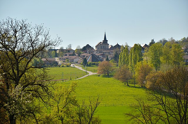
Attignat-Oncin
- коммуна во Франции
Hiking in Attignat-Oncin
Attignat-Oncin is a lovely commune in the Auvergne-Rhône-Alpes region of France, nestled at the foothills of the French Alps. It offers a range of hiking opportunities that cater to various skill levels, making it an ideal destination for nature lovers and outdoor enthusiasts....
- Страна:
- Почтовый код: 73610
- Координаты: 45° 30' 30" N, 5° 46' 33" E
- GPS треки (wikiloc): [Ссылка]
- Площадь: 18.46 кв.км
- Население: 527
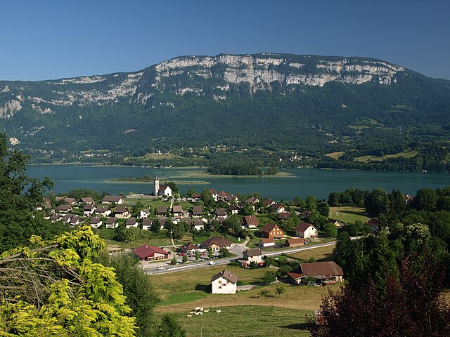

Saint-Alban-de-Montbel
- коммуна во Франции
Hiking in Saint-Alban-de-Montbel
Saint-Alban-de-Montbel is a picturesque village located near the shores of Lake Aiguebelette in the Savoie region of France. This area is rich in natural beauty, making it an excellent destination for hiking enthusiasts. Here are some aspects to consider if you're planning to hike in and around Saint-Alban-de-Montbel:...
- Страна:
- Почтовый код: 73610
- Координаты: 45° 33' 6" N, 5° 47' 0" E
- GPS треки (wikiloc): [Ссылка]
- Площадь: 4.55 кв.км
- Население: 622


Verel-de-Montbel
- коммуна во Франции
Hiking in Verel-de-Montbel
Verel-de-Montbel is a charming commune located in the Auvergne-Rhône-Alpes region of France, nestled at the edge of the Chartreuse Mountains. Hiking in this area offers a wonderful opportunity to explore scenic landscapes, diverse flora, and panoramic views of the surrounding mountains and lakes....
- Страна:
- Почтовый код: 73330
- Координаты: 45° 33' 33" N, 5° 43' 49" E
- GPS треки (wikiloc): [Ссылка]
- Площадь: 3.74 кв.км
- Население: 299

Dullin
- коммуна во Франции
Hiking in Dullin
Dullin, located in the Auvergne-Rhône-Alpes region of France, is a great destination for hiking enthusiasts. The area offers a variety of trails that cater to different skill levels, from gentle walks through picturesque landscapes to more challenging hikes that provide stunning views of the surrounding Alps....
- Страна:
- Почтовый код: 73610
- Координаты: 45° 33' 14" N, 5° 44' 41" E
- GPS треки (wikiloc): [Ссылка]
- Площадь: 5.31 кв.км
- Население: 409

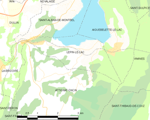
Lépin-le-Lac
- коммуна во Франции
Hiking in Lépin-le-Lac
Lépin-le-Lac, located in the idyllic Savoie region of the French Alps, offers an excellent opportunity for hiking enthusiasts seeking stunning landscapes and a mix of outdoor activities. Here’s a breakdown of what you can expect when hiking in this area:...
- Страна:
- Почтовый код: 73610
- Координаты: 45° 32' 7" N, 5° 47' 40" E
- GPS треки (wikiloc): [Ссылка]
- Площадь: 5.11 кв.км
- Население: 454