Saint-Béron (Saint-Béron)

- коммуна во Франции
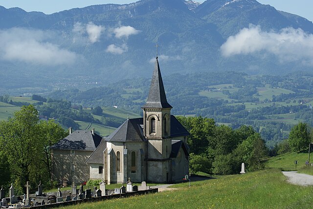
 Hiking in Saint-Béron
Saint-Béron is a charming commune located in the Savoie department of the Auvergne-Rhône-Alpes region in southeastern France. It's nestled in the foothills of the French Alps, providing some beautiful hiking opportunities for outdoor enthusiasts.
Hiking Opportunities in Saint-Béron
-
Scenic Trails: The area around Saint-Béron offers a variety of trails that cater to different skill levels, from beginner paths to more challenging hikes. The routes often provide stunning views of the surrounding mountains and valleys.
-
Nature and Wildlife: In addition to breathtaking landscapes, the region is rich in flora and fauna. Hikers may encounter diverse wildlife, including deer, various bird species, and a variety of plant life that flourishes in this mountainous area.
-
Local Attractions: While hiking, you can also explore local attractions, such as charming villages, historical sites, and traditional alpine architecture. This adds a cultural dimension to your hiking experience.
-
Weather Considerations: The weather can vary greatly in the Alps, so it's important to check forecasts before heading out. Be prepared with appropriate gear for changes in weather conditions.
-
Safety Tips: As with any hiking activity, make sure to stay on marked trails, bring enough water and snacks, and let someone know your plans before heading out. If you are unfamiliar with the area, consider hiring a local guide for a safer experience.
-
Nearby Hiking Areas: Saint-Béron is close to various larger hiking areas, such as the Chartreuse and Vercors mountains, which offer extensive networks of trails and are popular among experienced hikers.
Conclusion
Hiking in Saint-Béron is a fantastic way to immerse yourself in nature while enjoying the picturesque landscapes of the French Alps. Whether you are a seasoned hiker or a casual walker, there are options available that allow you to explore the region's natural beauty and cultural heritage. Just remember to prepare adequately and respect the environment during your adventures!
- Страна:

- Почтовый код: 73520
- Координаты: 45° 30' 5" N, 5° 43' 45" E


- GPS треки (wikiloc): [Ссылка]
- Площадь: 8.66 кв.км
- Население: 1656
- Википедия английская: wiki(en)
- Википедия национальная: wiki(fr)
- Хранилище Wikidata: Wikidata: Q1218370
- Катеория в википедии: [Ссылка]
- код Freebase: [/m/03npgmj]
- код Freebase: [/m/03npgmj]
- код GeoNames: Альт: [6442863]
- код GeoNames: Альт: [6442863]
- номер SIREN: [217302264]
- номер SIREN: [217302264]
- код BNF: [15274157v]
- код BNF: [15274157v]
- код муниципалитета INSEE: 73226
- код муниципалитета INSEE: 73226
Граничит с регионами:


Domessin
- коммуна во Франции
Hiking in Domessin
Domessin is a quaint commune located in the Savoie department in the Auvergne-Rhône-Alpes region of southeastern France. Nestled at the foot of the Chartreuse Mountains, this area offers a variety of hiking opportunities that cater to different skill levels....
- Страна:
- Почтовый код: 73330
- Координаты: 45° 32' 25" N, 5° 42' 33" E
- GPS треки (wikiloc): [Ссылка]
- Площадь: 9.83 кв.км
- Население: 1839
- Веб сайт: [Ссылка]

Saint-Franc
- коммуна во Франции
Hiking in Saint-Franc
Saint-Franc, often referred to in the context of Saint-François, is a scenic region located in Guadeloupe, known for its beautiful landscapes and diverse hiking opportunities. When hiking in this area, you can expect a mix of coastal and inland trails offering stunning views, lush vegetation, and unique wildlife....
- Страна:
- Почтовый код: 73360
- Координаты: 45° 29' 29" N, 5° 44' 46" E
- GPS треки (wikiloc): [Ссылка]
- Площадь: 7.25 кв.км
- Население: 166


Attignat-Oncin
- коммуна во Франции
Hiking in Attignat-Oncin
Attignat-Oncin is a lovely commune in the Auvergne-Rhône-Alpes region of France, nestled at the foothills of the French Alps. It offers a range of hiking opportunities that cater to various skill levels, making it an ideal destination for nature lovers and outdoor enthusiasts....
- Страна:
- Почтовый код: 73610
- Координаты: 45° 30' 30" N, 5° 46' 33" E
- GPS треки (wikiloc): [Ссылка]
- Площадь: 18.46 кв.км
- Население: 527


Сент-Альбен-де-Вольсерр
- коммуна во Франции
Hiking in Сент-Альбен-де-Вольсерр
Saint-Albin-de-Vaulserre is a charming commune located in the Isère department in the Auvergne-Rhône-Alpes region of southeastern France. While it is not as well-known as other hiking destinations, it offers beautiful rural landscapes and access to outdoor activities that can be enjoyed by hikers of all levels....
- Страна:
- Почтовый код: 38480
- Координаты: 45° 30' 17" N, 5° 42' 9" E
- GPS треки (wikiloc): [Ссылка]
- Площадь: 4.99 кв.км
- Население: 400


Вуассан
- коммуна во Франции
Hiking in Вуассан
Voissant is a charming village located in the Isère department of the Auvergne-Rhône-Alpes region in southeastern France. While it may not be as widely known as some of the larger hiking destinations, it offers a variety of outdoor activities and hiking opportunities amidst beautiful natural settings....
- Страна:
- Почтовый код: 38620
- Координаты: 45° 29' 1" N, 5° 42' 36" E
- GPS треки (wikiloc): [Ссылка]
- Площадь: 3.88 кв.км
- Население: 218


La Bridoire
- коммуна во Франции
Hiking in La Bridoire
La Bridoire is a charming commune located in the Savoie department of the Auvergne-Rhône-Alpes region in southeastern France. It is set in a scenic area that offers a variety of hiking opportunities amidst beautiful landscapes....
- Страна:
- Почтовый код: 73520
- Координаты: 45° 31' 34" N, 5° 44' 33" E
- GPS треки (wikiloc): [Ссылка]
- Площадь: 6.18 кв.км
- Население: 1238