Кордеак (Cordéac, Cordéac)

- коммуна во Франции
 Hiking in Кордеак
Cordéac is a small village located in the French Alps, offering stunning natural landscapes ideal for hiking. The region is well-suited for both experienced hikers and those looking for gentler trails. Here are some highlights to consider when hiking in Cordéac:
Trails and Routes
-
Local Trails: There are well-marked trails in and around Cordéac that typically range from easy to moderate difficulty. Look for paths leading to scenic viewpoints, alpine meadows, and lakes.
-
Alps Hiking Circuit: Depending on your skill level, you can explore sections of the GR (Grande Randonnée) routes that pass nearby. These trails can lead you through diverse terrains and provide stunning panoramic views of the surrounding mountains.
-
La Grotte de Saint-Bonnet: A shorter hike that leads to a cave with historical significance. This trail is suitable for families and offers a glimpse into the local natural history.
Seasonal Considerations
-
Summer Hiking: The summer months are ideal for hiking, with wildflowers in bloom and accessible high-altitude routes. Ensure you carry plenty of water and snacks.
-
Autumn Colors: Early fall offers beautiful foliage, making for picturesque hikes as the leaves change.
-
Winter Sports: In winter, the area transforms with snow, providing opportunities for snowshoeing or skiing rather than traditional hiking.
Preparation Tips
-
Gear: Wear sturdy hiking shoes and be prepared for variable weather. Layers are essential in the mountains, as temperatures can change rapidly.
-
Maps and Navigation: It's advisable to have a local map or GPS device, as some paths might not be well-signposted.
-
Wildlife Caution: The area is home to diverse wildlife, so it's important to be respectful of nature and follow safe wildlife practices.
-
Respect Nature: Adhere to the "Leave No Trace" principles to help preserve the beautiful environment.
Local Amenities
Cordéac, being a small village, may have limited amenities, so it’s a good idea to plan for food and supplies ahead of your hike. Check if there are local accommodations if you plan to stay overnight.
Always remember to check local resources or talk to local guides for the latest information on trail conditions and safety guidelines before setting out. Enjoy your adventure in Cordéac!
- Страна:

- Почтовый код: 38710
- Координаты: 44° 49' 38" N, 5° 50' 17" E


- GPS треки (wikiloc): [Ссылка]
- Площадь: 26.62 кв.км
- Население: 200
- Википедия русская: wiki(ru)
- Википедия английская: wiki(en)
- Википедия национальная: wiki(fr)
- Хранилище Wikidata: Wikidata: Q1069704
- Катеория в википедии: [Ссылка]
- код Freebase: [/m/03nvh88]
- код GeoNames: Альт: [6433175]
- код BNF: [15257948d]
- код муниципалитета INSEE: 38125
Граничит с регионами:

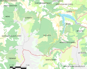
Пеллафоль
- коммуна во Франции
Hiking in Пеллафоль
Pellafol, a picturesque village located in the Isère department of the Auvergne-Rhône-Alpes region in France, is a hidden gem for hiking enthusiasts. Nestled in the foothills of the French Alps, it offers stunning landscapes, diverse flora and fauna, and a variety of trails suitable for all skill levels....
- Страна:
- Почтовый код: 38970
- Координаты: 44° 47' 51" N, 5° 54' 27" E
- GPS треки (wikiloc): [Ссылка]
- Площадь: 34.73 кв.км
- Население: 137


Сен-Бодий-э-Пипе
- коммуна во Франции
Hiking in Сен-Бодий-э-Пипе
Saint-Baudille-et-Pipet is a charming commune located in the Auvergne-Rhône-Alpes region of France, surrounded by beautiful natural landscapes that are perfect for hiking enthusiasts. The area offers a variety of trails that cater to different skill levels, making it an excellent destination for both novices and experienced hikers....
- Страна:
- Почтовый код: 38710
- Координаты: 44° 47' 3" N, 5° 46' 7" E
- GPS треки (wikiloc): [Ссылка]
- Площадь: 35.97 кв.км
- Население: 257

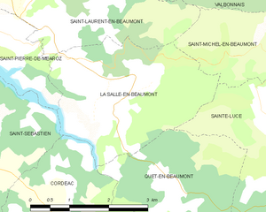
Ла-Саль-ан-Бомон
- коммуна во Франции
Hiking in Ла-Саль-ан-Бомон
La Salle-en-Beaumont is a picturesque commune located in the Isère department of the Auvergne-Rhône-Alpes region in southeastern France. It is surrounded by the stunning natural landscapes of the French Alps, making it an excellent destination for hiking enthusiasts....
- Страна:
- Почтовый код: 38350
- Координаты: 44° 51' 43" N, 5° 51' 50" E
- GPS треки (wikiloc): [Ссылка]
- Площадь: 9.26 кв.км
- Население: 323
- Веб сайт: [Ссылка]


Сен-Себастьен
Hiking in Сен-Себастьен
Saint-Sébastien is a charming commune in the Isère department of the Auvergne-Rhône-Alpes region in France. The area is known for its beautiful mountain landscapes, making it an excellent destination for hiking enthusiasts. Here are some insights into hiking in and around Saint-Sébastien:...
- Страна:
- Почтовый код: 38710
- Координаты: 44° 50' 50" N, 5° 47' 57" E
- GPS треки (wikiloc): [Ссылка]
- Площадь: 20.98 кв.км
- Население: 259
- Веб сайт: [Ссылка]


Манс
Hiking in Манс
Hiking in the Vercors region of Isère, particularly around Mens, offers a fantastic blend of natural beauty, diverse terrain, and rich cultural heritage. Here are some highlights and tips for hiking in the area:...
- Страна:
- Почтовый код: 38710
- Координаты: 44° 49' 1" N, 5° 45' 1" E
- GPS треки (wikiloc): [Ссылка]
- Площадь: 28.29 кв.км
- Население: 1379
- Веб сайт: [Ссылка]


Кет-ан-Бомон
- коммуна во Франции
Hiking in Кет-ан-Бомон
Quet-en-Beaumont is a charming destination for hiking enthusiasts. Nestled in the beautiful surroundings of the French Alps, this area offers a range of hiking trails suitable for various skill levels. Here are some key points to consider for your hiking adventure in Quet-en-Beaumont:...
- Страна:
- Почтовый код: 38970
- Координаты: 44° 50' 5" N, 5° 52' 25" E
- GPS треки (wikiloc): [Ссылка]
- Площадь: 8.1 кв.км
- Население: 65