
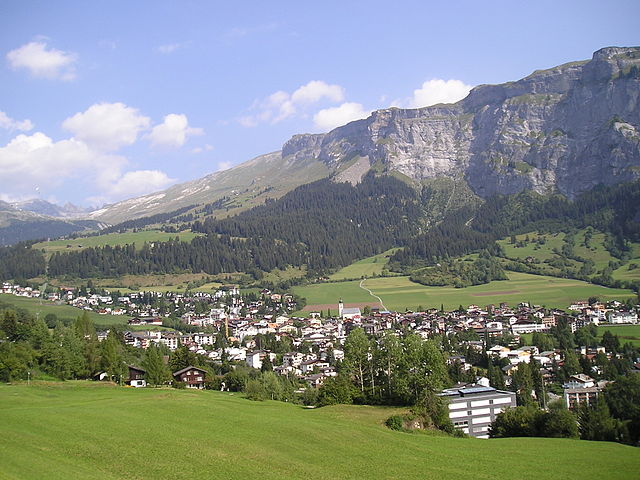
Лакс (Laax, Laax)

 Hiking in Лакс
Laax, located in the Swiss Alps in the canton of Graubünden, is a fantastic destination for hiking enthusiasts. Known for its breathtaking landscapes, diverse trails, and stunning alpine scenery, Laax offers hiking options for all skill levels. Here are some key aspects to consider if you're planning to hike in Laax:
Trail Diversity
- Variety of Trails: Laax has a rich network of hiking trails that cater to different levels of difficulty. From easy family-friendly routes to challenging alpine hikes, there's something for everyone.
- Scenic Views: Many trails provide spectacular views of the surrounding mountains, including the famous Rhine Gorge, often referred to as the Grand Canyon of Switzerland.
- Alpine Flora and Fauna: As you hike, you can expect to see diverse wildlife and beautiful alpine plants, especially during the summer months when flowers are in full bloom.
Popular Hiking Routes
- Flims-Laax Trail: This trail offers stunning views and easy accessibility. It connects the villages of Flims and Laax with picturesque landscapes.
- Technoalpin: Peak Walk: A hike that leads to a viewpoint providing panoramic views of the Alps.
- Arosa-Lai Trail: A longer hike that features beautiful lakes and unique rock formations.
Seasonal Considerations
- Summer Hiking: The best time for hiking in Laax is from late June to early October when trails are usually clear of snow and well-maintained.
- Winter Hiking/Snowshoeing: In winter, Laax becomes a winter sports paradise, but there are also designated winter hiking and snowshoeing trails that allow you to enjoy the snowy landscape.
Tips
- Weather Awareness: The weather in the Alps can change rapidly. Always check forecasts and be prepared for sudden weather changes.
- Proper Gear: Wear sturdy hiking boots, and bring layers to accommodate temperature shifts. Don't forget essentials such as water, snacks, and a map or GPS device.
- Respect Nature: Follow the 'Leave No Trace' principles to preserve the natural beauty of the area.
Access and Facilities
- Getting There: Laax is easily accessible by public transport or car, with parking available at various trailheads.
- Guided Tours: If you're not familiar with the area, consider joining guided hiking tours for expert knowledge and safety.
Hiking in Laax allows you to immerse yourself in the stunning Swiss landscape while enjoying the tranquility and beauty of nature. Whether you are a casual hiker or a seasoned adventurer, Laax has something special to offer!
- Страна:

- Почтовый код: 7031
- Телефонный код: 081
- Код автомобильного номера: GR
- Координаты: 46° 50' 45" N, 9° 13' 40" E


- GPS треки (wikiloc): [Ссылка]
- Высота над уровнем моря: 1685 м m
- Площадь: 31.68 кв.км
- Население: 1755
- Веб сайт: http://www.laax-gr.ch
- Википедия русская: wiki(ru)
- Википедия английская: wiki(en)
- Википедия национальная: wiki(de)
- Хранилище Wikidata: Wikidata: Q69606
- Катеория в википедии: [Ссылка]
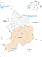
Граничит с регионами:

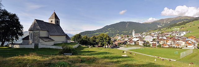
Флимс
Hiking in Флимс
Flims, located in the Swiss canton of Graubünden, is a fantastic destination for hiking enthusiasts. This picturesque region offers stunning scenery, including impressive rock formations, forests, alpine meadows, and beautiful lakes. Here are some highlights and essential information for hiking in Flims:...
- Страна:
- Почтовый код: 7017
- Телефонный код: 081
- Код автомобильного номера: GR
- Координаты: 46° 49' 59" N, 9° 16' 59" E
- GPS треки (wikiloc): [Ссылка]
- Высота над уровнем моря: 1848 м m
- Площадь: 50.46 кв.км
- Население: 2825
- Веб сайт: [Ссылка]

Фалера
Hiking in Фалера
Falera is a picturesque village in the Swiss Alps, located in the canton of Graubünden. The region is known for its breathtaking landscapes, rich history, and excellent hiking opportunities. Here’s what you should know about hiking in Falera:...
- Страна:
- Почтовый код: 7153
- Телефонный код: 081
- Код автомобильного номера: GR
- Координаты: 46° 49' 38" N, 9° 12' 31" E
- GPS треки (wikiloc): [Ссылка]
- Высота над уровнем моря: 1982 м m
- Площадь: 22.36 кв.км
- Население: 623
- Веб сайт: [Ссылка]


Сагонь
Hiking in Сагонь
Sagogn is a charming village located in the Swiss canton of Graubünden, nestled amid stunning alpine scenery. It's an excellent destination for hiking enthusiasts, offering a variety of trails suitable for different skill levels. Here are some key points to consider when hiking in and around Sagogn:...
- Страна:
- Почтовый код: 7152
- Телефонный код: 081
- Код автомобильного номера: GR
- Координаты: 46° 47' 32" N, 9° 15' 21" E
- GPS треки (wikiloc): [Ссылка]
- Высота над уровнем моря: 809 м m
- Площадь: 6.92 кв.км
- Население: 686
- Веб сайт: [Ссылка]


Рушайн
Hiking in Рушайн
Ruschein, located in the Grisons region of Switzerland, offers beautiful landscapes and a variety of hiking trails suitable for all levels of experience. The area is characterized by stunning alpine scenery, including lush meadows, rugged mountains, and picturesque valleys....
- Страна:
- Почтовый код: 7154
- Телефонный код: 081
- Код автомобильного номера: GR
- Координаты: 46° 46' 59" N, 9° 11' 0" E
- GPS треки (wikiloc): [Ссылка]
- Высота над уровнем моря: 1155 м m
- Площадь: 12.54 кв.км
- Веб сайт: [Ссылка]

Glarus Süd
Hiking in Glarus Süd
Glarus Süd, located in the canton of Glarus in Switzerland, is a fantastic destination for hiking enthusiasts. This region boasts stunning landscapes, ranging from lush valleys to rugged mountain terrains. Here are some key points about hiking in Glarus Süd:...
- Страна:
- Почтовый код: 8756, 8762, 8765, 8766, 8767, 8772, 8773, 8774, 8775, 8777, 8782, 8783, 8784
- Телефонный код: 055
- Код автомобильного номера: GL
- Координаты: 46° 59' 40" N, 9° 4' 27" E
- GPS треки (wikiloc): [Ссылка]
- Высота над уровнем моря: 521 м m
- Площадь: 430.2 кв.км
- Население: 9581
- Веб сайт: [Ссылка]