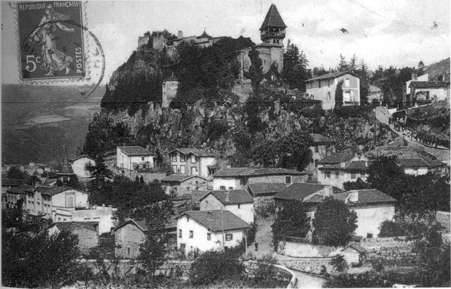
Манс (Mens, Mens)

 Hiking in Манс
Hiking in the Vercors region of Isère, particularly around Mens, offers a fantastic blend of natural beauty, diverse terrain, and rich cultural heritage. Here are some highlights and tips for hiking in the area:
Scenic Trails
-
Sentier des Dentelles: A popular trail that provides stunning views of the surrounding mountains and valleys. The route can vary in difficulty, making it suitable for both beginners and experienced hikers.
-
La Grotte de la Luire: This area features several trails leading to impressive caves and natural formations. The hike to the cave is relatively easy and offers an educational experience about the local geology.
-
Le Mont Aiguille: Although challenging, this iconic peak is a must for dedicated hikers. The trail offers thrilling views and a sense of accomplishment upon reaching the summit.
Flora and Fauna
The Vercors region is known for its diverse ecosystems. Hikers can encounter a variety of wildlife, such as chamois, deer, and numerous bird species. The flora is equally rich, with wildflowers in spring and lush greenery during the summer months.
Best Time to Hike
Late spring to early fall (May to September) is the best time for hiking in the Mens area. The weather is generally mild, though summer can get warm, so it's essential to carry enough water. Autumn also offers beautiful foliage and mild temperatures, making it a great time for hiking.
Local Tips
- Maps and Markings: Always carry a detailed map of the hiking trails as well as a compass or GPS device. Trails are usually well-marked but can be tricky in less frequented areas.
- Weather Conditions: The weather can change rapidly in mountainous areas, so always check the forecast beforehand and be prepared for sudden changes.
- Guided Tours: If you're unfamiliar with the area or want to learn more about the local culture and environment, consider joining a guided hiking tour.
Accommodations and Facilities
Mens has various options for accommodations, ranging from camping sites to local inns. Be sure to book in advance during peak hiking seasons. There are also local shops and restaurants where hikers can rejuvenate after a long day on the trails.
Conclusion
Hiking in Mens, Isère offers a rewarding experience with breathtaking landscapes, diverse wildlife, and the chance to explore the unique Montagnard culture. Whether you're a seasoned hiker or a novice looking for a day hike, there's something for everyone in this beautiful region. Always prioritize safety and enjoy your adventure!
- Страна:

- Почтовый код: 38710
- Координаты: 44° 49' 1" N, 5° 45' 1" E


- GPS треки (wikiloc): [Ссылка]
- Площадь: 28.29 кв.км
- Население: 1379
- Веб сайт: http://www.mairie-de-mens.fr
- Википедия русская: wiki(ru)
- Википедия английская: wiki(en)
- Википедия национальная: wiki(fr)
- Хранилище Wikidata: Wikidata: Q660030
- Катеория в википедии: [Ссылка]
- код Freebase: [/m/03g_4vr]
- код GeoNames: Альт: [6433238]
- номер SIREN: [213802267]
- код BNF: [15258040d]
- код VIAF: Альт: [216665077]
- WOEID: [611022]
- код муниципалитета INSEE: 38226
Граничит с регионами:


Кордеак
- коммуна во Франции
Hiking in Кордеак
Cordéac is a small village located in the French Alps, offering stunning natural landscapes ideal for hiking. The region is well-suited for both experienced hikers and those looking for gentler trails. Here are some highlights to consider when hiking in Cordéac:...
- Страна:
- Почтовый код: 38710
- Координаты: 44° 49' 38" N, 5° 50' 17" E
- GPS треки (wikiloc): [Ссылка]
- Площадь: 26.62 кв.км
- Население: 200
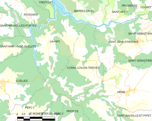
Корнийон-ан-Триев
- коммуна во Франции
Hiking in Корнийон-ан-Триев
Cornillon-en-Trièves is a charming village located in the Trièves region of the French Alps, in the department of Isère. It offers a range of hiking opportunities that showcase the stunning natural beauty of the surrounding landscape, including mountains, forests, and picturesque views of the surrounding valleys....
- Страна:
- Почтовый код: 38710
- Координаты: 44° 49' 46" N, 5° 43' 3" E
- GPS треки (wikiloc): [Ссылка]
- Площадь: 13.92 кв.км
- Население: 169


Сен-Жан-д'Эран
- коммуна во Франции
Hiking in Сен-Жан-д'Эран
Saint-Jean-d'Hérans is a picturesque village located in the Isère department of the Auvergne-Rhône-Alpes region in southeastern France. It offers beautiful hiking opportunities set against the backdrop of stunning natural landscapes, including mountains, forests, and rivers....
- Страна:
- Почтовый код: 38710
- Координаты: 44° 51' 12" N, 5° 45' 39" E
- GPS треки (wikiloc): [Ссылка]
- Площадь: 17.48 кв.км
- Население: 295


Сен-Бодий-э-Пипе
- коммуна во Франции
Hiking in Сен-Бодий-э-Пипе
Saint-Baudille-et-Pipet is a charming commune located in the Auvergne-Rhône-Alpes region of France, surrounded by beautiful natural landscapes that are perfect for hiking enthusiasts. The area offers a variety of trails that cater to different skill levels, making it an excellent destination for both novices and experienced hikers....
- Страна:
- Почтовый код: 38710
- Координаты: 44° 47' 3" N, 5° 46' 7" E
- GPS треки (wikiloc): [Ссылка]
- Площадь: 35.97 кв.км
- Население: 257

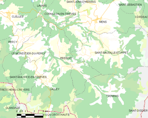
Пребуа
- коммуна во Франции
Hiking in Пребуа
Prébois is a scenic area located in the French Alps, known for its stunning landscapes, diverse flora and fauna, and hiking opportunities. Here are some key points to consider if you're planning a hike in Prébois:...
- Страна:
- Почтовый код: 38710
- Координаты: 44° 47' 22" N, 5° 41' 42" E
- GPS треки (wikiloc): [Ссылка]
- Площадь: 16.03 кв.км
- Население: 165
- Веб сайт: [Ссылка]


Сен-Себастьен
Hiking in Сен-Себастьен
Saint-Sébastien is a charming commune in the Isère department of the Auvergne-Rhône-Alpes region in France. The area is known for its beautiful mountain landscapes, making it an excellent destination for hiking enthusiasts. Here are some insights into hiking in and around Saint-Sébastien:...
- Страна:
- Почтовый код: 38710
- Координаты: 44° 50' 50" N, 5° 47' 57" E
- GPS треки (wikiloc): [Ссылка]
- Площадь: 20.98 кв.км
- Население: 259
- Веб сайт: [Ссылка]