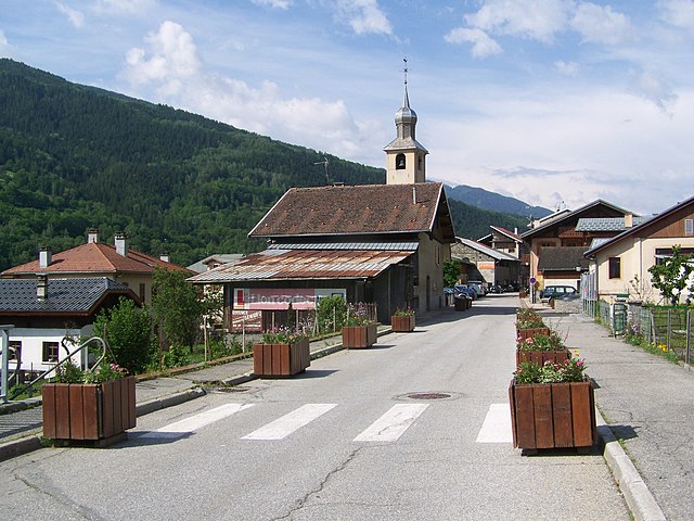
Peisey-Nancroix (Peisey-Nancroix)

- коммуна во Франции
 Hiking in Peisey-Nancroix
Peisey-Nancroix is a beautiful alpine village located in the Tarentaise Valley in the Savoie region of the French Alps. It serves as a gateway to some stunning hiking trails, particularly within the Vanoise National Park, which is famous for its diverse landscapes, wildlife, and breathtaking views. Here are some highlights and tips for hiking in the Peisey-Nancroix area:
Hiking Trails
-
Les Arcs and Peisey-Vallandry Trails: The area offers a range of marked trails suitable for all levels, from easy walks to challenging mountain hikes. Popular routes include those that lead to mountain lakes or provide access to panoramic viewpoints over the surrounding peaks.
-
Vanoise National Park: This is the first national park established in France and a UNESCO Biosphere Reserve. It is renowned for its beautiful scenery and rich biodiversity. Various trails can take you deeper into the park, where you may spot ibex, chamois, and marmots.
-
Lac de la Plagne: A moderate hike will lead you to this stunning glacial lake, which is a popular destination for hikers looking for a scenic picnic spot.
-
Refuge Hiking: Consider hiking to mountain huts (refuges) like the Refuge de l’Arpont or Refuge de la Nova, where you can enjoy traditional Savoyard cuisine and possibly stay overnight.
Difficulty Levels
- Easy Trails: Suitable for families and beginners, generally well-marked and accessible.
- Intermediate Trails: More challenging, suitable for those with some hiking experience.
- Difficult Trails: These are for experienced hikers, often involving vertical climbs and rough terrain.
Best Time to Hike
- Summer: From late June to early September is the best time for hiking, as the weather is typically mild and the trails are fully accessible.
- Fall: Late September to October can also be beautiful, especially for those who enjoy the autumn colors. Be mindful of snowfall at higher altitudes.
Tips for Hiking in Peisey-Nancroix
- Weather: Always check the weather forecast before heading out, as conditions can change rapidly in the mountains.
- Gear: Wear sturdy hiking boots, dress in layers, and carry plenty of water and snacks. A map or GPS device is also recommended.
- Respect Nature: Follow Leave No Trace principles to help preserve the beauty of the alpine environment.
- Stay Safe: Let someone know your hiking plans, especially if heading into more remote areas.
Getting There
Peisey-Nancroix is accessible by car, and there are also public transport options from nearby towns. The nearest major town is Bourg-Saint-Maurice, which connects to several ski resorts and hiking areas.
Overall, hiking in Peisey-Nancroix offers stunning natural beauty, a variety of trails, and an opportunity to experience the tranquility and majesty of the French Alps. Whether you're a seasoned hiker or a beginner, you'll find some incredible adventures waiting for you in this picturesque region.
- Страна:

- Почтовый код: 73210
- Координаты: 45° 32' 47" N, 6° 45' 23" E


- GPS треки (wikiloc): [Ссылка]
- Площадь: 70.64 кв.км
- Население: 640
- Википедия английская: wiki(en)
- Википедия национальная: wiki(fr)
- Хранилище Wikidata: Wikidata: Q683625
- Катеория в википедии: [Ссылка]
- код Freebase: [/m/03cc043]
- код Freebase: [/m/03cc043]
- код GeoNames: Альт: [2988203]
- код GeoNames: Альт: [2988203]
- номер SIREN: [217301977]
- номер SIREN: [217301977]
- код BNF: [152741288]
- код BNF: [152741288]
- код VIAF: Альт: [126730491]
- код VIAF: Альт: [126730491]
- код LCNAF: Альт: [n85075658]
- код LCNAF: Альт: [n85075658]
- код тезауруса PACTOLS: [pcrtt4VRwFgSN5]
- код тезауруса PACTOLS: [pcrtt4VRwFgSN5]
- код TGN: [1034819]
- код TGN: [1034819]
- код муниципалитета INSEE: 73197
- код муниципалитета INSEE: 73197
Граничит с регионами:

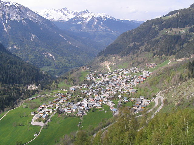
Bellentre
- коммуна во Франции
Hiking in Bellentre
Bellentre is a charming commune located in the Savoie department of the Auvergne-Rhône-Alpes region in southeastern France. It’s situated in the heart of the French Alps, making it a fantastic destination for hiking enthusiasts. Here are some key aspects to consider when hiking in Bellentre:...
- Страна:
- Почтовый код: 73210
- Координаты: 45° 34' 10" N, 6° 42' 50" E
- GPS треки (wikiloc): [Ссылка]
- Площадь: 23.94 кв.км
- Население: 924


Villaroger
- коммуна во Франции
Hiking in Villaroger
Villaroger is a charming village located in the French Alps, within the Tarentaise Valley in the Savoie region. It offers a range of hiking opportunities, making it an attractive destination for outdoor enthusiasts. Here are some key points to consider when hiking in Villaroger:...
- Страна:
- Почтовый код: 73640
- Координаты: 45° 35' 28" N, 6° 52' 28" E
- GPS треки (wikiloc): [Ссылка]
- Площадь: 28.15 кв.км
- Население: 387

Champagny-en-Vanoise
- коммуна во Франции
Hiking in Champagny-en-Vanoise
Champagny-en-Vanoise is a picturesque village located in the Savoie region of the French Alps, and it serves as a fantastic base for hiking enthusiasts exploring the Vanoise National Park. The area is known for its stunning mountain scenery, diverse flora and fauna, and well-marked hiking trails suitable for all skill levels. Here are some key points about hiking in Champagny-en-Vanoise:...
- Страна:
- Почтовый код: 73350
- Координаты: 45° 27' 16" N, 6° 41' 33" E
- GPS треки (wikiloc): [Ссылка]
- Площадь: 84.96 кв.км
- Население: 605
- Веб сайт: [Ссылка]
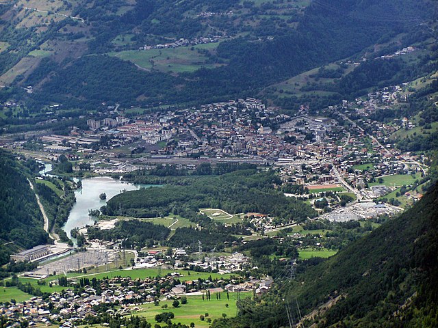

Бур-Сен-Морис
- коммуна во Франции
Hiking in Бур-Сен-Морис
Bourg-Saint-Maurice, located in the Savoie region of the French Alps, is a fantastic destination for hikers. It offers stunning alpine scenery, a variety of trails suitable for different skill levels, and access to some of the most beautiful landscapes in the region, including the Vanoise National Park....
- Страна:
- Почтовый код: 73700
- Координаты: 45° 37' 0" N, 6° 46' 7" E
- GPS треки (wikiloc): [Ссылка]
- Высота над уровнем моря: 744 м m
- Площадь: 179.07 кв.км
- Население: 7228
- Веб сайт: [Ссылка]


Тинь
- коммуна во Франции
Hiking in Тинь
Tignes is a beautiful alpine resort located in the French Alps, renowned for both its skiing and summer hiking opportunities. Here are some insights into hiking in Tignes:...
- Страна:
- Почтовый код: 73320
- Координаты: 45° 28' 11" N, 6° 54' 34" E
- GPS треки (wikiloc): [Ссылка]
- Площадь: 81.63 кв.км
- Население: 2569
- Веб сайт: [Ссылка]
Landry, Savoie
- коммуна во Франции
Hiking in Landry, Savoie
Landry, located in the Savoie region of the French Alps, is an excellent destination for hiking enthusiasts. The area is known for its stunning natural landscapes, characterized by majestic mountains, lush valleys, and diverse wildlife. Here are some key points about hiking in Landry:...
- Страна:
- Почтовый код: 73210
- Координаты: 45° 34' 16" N, 6° 44' 26" E
- GPS треки (wikiloc): [Ссылка]
- Площадь: 10.62 кв.км
- Население: 843
- Веб сайт: [Ссылка]