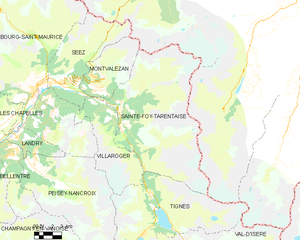
Бур-Сен-Морис (canton of Bourg-Saint-Maurice, canton de Bourg-Saint-Maurice)

 Hiking in Бур-Сен-Морис
The Canton of Bourg-Saint-Maurice, nestled in the French Alps, is renowned for its stunning landscapes and extensive hiking opportunities. This area is part of the Savoie region and offers a mix of alpine scenery, charming villages, and diverse trails suitable for all levels of hikers.
Key Highlights for Hiking in Bourg-Saint-Maurice:
-
The Vanoise National Park: One of the first national parks in France, Vanoise is just a short distance away and boasts over 600 kilometers of marked trails. The park is famous for its wildlife, including ibex and chamois, as well as breathtaking views of glaciers and high peaks.
-
Les Arcs and Peisey-Vallandry: These interconnected ski resorts transform into hiker-friendly areas in the summer. There are numerous trails that lead through beautiful alpine meadows and offer panoramic views of the surrounding mountains. Easy trails are available for families, while more challenging options cater to experienced hikers.
-
Chamonix and Mont Blanc Range: For those seeking a more strenuous hike, the paths that lead towards the Mont Blanc massif are accessible from Bourg-Saint-Maurice. Trails like the Tour du Mont Blanc attract many hikers looking for multi-day adventures.
-
Gorges de la Diosaz: A relatively easy hike that leads you through unique geological formations and offers thrilling views of waterfalls and the gorge itself.
-
Lac de la Sassière: A stunning alpine lake that is a moderate hike from the start point and makes for a perfect picnic spot, surrounded by incredible scenery.
Practical Tips:
-
Best Time to Hike: The hiking season typically runs from late June to early September, when the trails are free of snow. Late spring and early fall can also be beautiful for hiking but may come with unpredictably cooler weather.
-
Gear: Ensure you have proper hiking boots, layered clothing, a reliable map or GPS, and sufficient water and snacks. A first aid kit is always a good idea.
-
Local Guides: If you are unsure about trail conditions or would like to enhance your experience, consider hiring a local guide. They can provide insights into the area’s natural history and hidden gems.
-
Respect Nature: Always follow the Leave No Trace principles, stick to marked trails, and respect the local wildlife.
Hiking in the Canton of Bourg-Saint-Maurice is truly an enriching experience that combines stunning natural beauty with opportunities for adventure in one of the most picturesque regions of the French Alps. Whether you're looking for a leisurely stroll or a challenging trek, this area has something to offer every kind of hiker.
- Страна:

- Столица: Бур-Сен-Морис
- Координаты: 45° 34' 6" N, 6° 50' 55" E


- GPS треки (wikiloc): [Ссылка]
- Население: 25755
- Википедия русская: wiki(ru)
- Википедия английская: wiki(en)
- Википедия национальная: wiki(fr)
- Хранилище Wikidata: Wikidata: Q1724564
- код кантона INSEE: [7305]
Включает регионы:


Villaroger
- коммуна во Франции
Hiking in Villaroger
Villaroger is a charming village located in the French Alps, within the Tarentaise Valley in the Savoie region. It offers a range of hiking opportunities, making it an attractive destination for outdoor enthusiasts. Here are some key points to consider when hiking in Villaroger:...
- Страна:
- Почтовый код: 73640
- Координаты: 45° 35' 28" N, 6° 52' 28" E
- GPS треки (wikiloc): [Ссылка]
- Площадь: 28.15 кв.км
- Население: 387


Валь-д'Изер
- коммуна во Франции
Hiking in Валь-д'Изер
Val-d'Isère, located in the French Alps, is a renowned ski resort that also offers spectacular hiking opportunities during the summer months. The area is known for its breathtaking mountain scenery, alpine meadows, and a variety of hiking trails suitable for different skill levels. Here are some highlights to consider if you plan to hike in Val-d'Isère:...
- Страна:
- Почтовый код: 73150
- Координаты: 45° 26' 59" N, 6° 58' 38" E
- GPS треки (wikiloc): [Ссылка]
- Высота над уровнем моря: 1850 м m
- Площадь: 94.39 кв.км
- Население: 1583
- Веб сайт: [Ссылка]


La Plagne-Tarentaise
Hiking in La Plagne-Tarentaise
La Plagne-Tarentaise is a stunning hiking destination located in the French Alps, renowned for its scenic beauty, diverse trails, and rich alpine wildlife. Here are some key points to consider if you're planning to hike in this region:...
- Страна:
- Почтовый код: 73210
- Координаты: 45° 33' 16" N, 6° 40' 22" E
- GPS треки (wikiloc): [Ссылка]
- Площадь: 96.07 кв.км


Aime-la-Plagne
Hiking in Aime-la-Plagne
Aime-la-Plagne, located in the French Alps, is a fantastic destination for hiking enthusiasts of all skill levels. Nestled within the Paradiski ski area, this region offers breathtaking views, diverse trails, and a rich Alpine landscape, making it an excellent choice for summer hiking....
- Страна:
- Почтовый код: 73210
- Координаты: 45° 33' 35" N, 6° 39' 6" E
- GPS треки (wikiloc): [Ссылка]
- Площадь: 94.67 кв.км
- Веб сайт: [Ссылка]
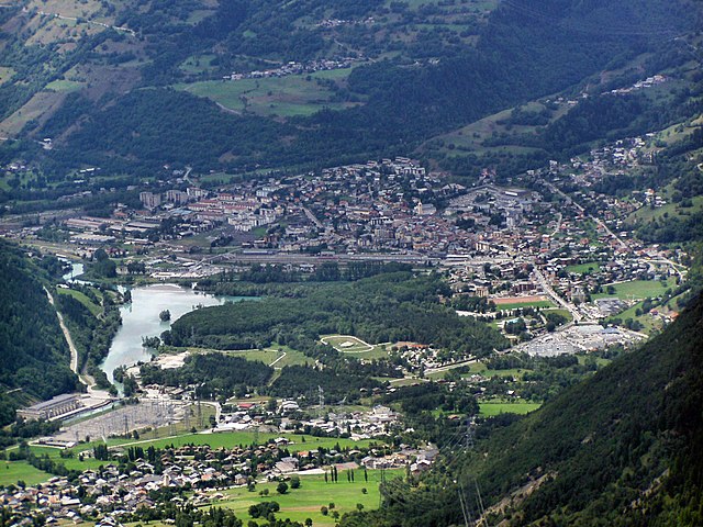

Бур-Сен-Морис
- коммуна во Франции
Hiking in Бур-Сен-Морис
Bourg-Saint-Maurice, located in the Savoie region of the French Alps, is a fantastic destination for hikers. It offers stunning alpine scenery, a variety of trails suitable for different skill levels, and access to some of the most beautiful landscapes in the region, including the Vanoise National Park....
- Страна:
- Почтовый код: 73700
- Координаты: 45° 37' 0" N, 6° 46' 7" E
- GPS треки (wikiloc): [Ссылка]
- Высота над уровнем моря: 744 м m
- Площадь: 179.07 кв.км
- Население: 7228
- Веб сайт: [Ссылка]


Тинь
- коммуна во Франции
Hiking in Тинь
Tignes is a beautiful alpine resort located in the French Alps, renowned for both its skiing and summer hiking opportunities. Here are some insights into hiking in Tignes:...
- Страна:
- Почтовый код: 73320
- Координаты: 45° 28' 11" N, 6° 54' 34" E
- GPS треки (wikiloc): [Ссылка]
- Площадь: 81.63 кв.км
- Население: 2569
- Веб сайт: [Ссылка]


Montvalezan
- коммуна во Франции
Hiking in Montvalezan
Montvalezan, nestled in the Savoie region of the French Alps, offers a stunning backdrop for hiking enthusiasts. This area is particularly known for its proximity to the vast Ski Paradiski area, which includes Les Arcs and La Plagne, but it also boasts fantastic summer hiking opportunities....
- Страна:
- Почтовый код: 73700
- Координаты: 45° 36' 43" N, 6° 50' 48" E
- GPS треки (wikiloc): [Ссылка]
- Площадь: 25.9 кв.км
- Население: 695
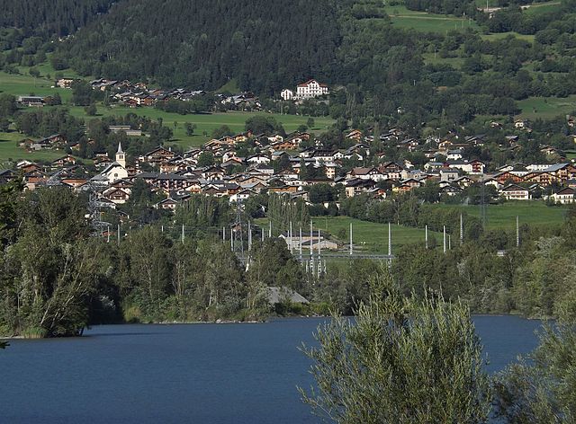
Landry, Savoie
- коммуна во Франции
Hiking in Landry, Savoie
Landry, located in the Savoie region of the French Alps, is an excellent destination for hiking enthusiasts. The area is known for its stunning natural landscapes, characterized by majestic mountains, lush valleys, and diverse wildlife. Here are some key points about hiking in Landry:...
- Страна:
- Почтовый код: 73210
- Координаты: 45° 34' 16" N, 6° 44' 26" E
- GPS треки (wikiloc): [Ссылка]
- Площадь: 10.62 кв.км
- Население: 843
- Веб сайт: [Ссылка]


Peisey-Nancroix
- коммуна во Франции
Hiking in Peisey-Nancroix
Peisey-Nancroix is a beautiful alpine village located in the Tarentaise Valley in the Savoie region of the French Alps. It serves as a gateway to some stunning hiking trails, particularly within the Vanoise National Park, which is famous for its diverse landscapes, wildlife, and breathtaking views. Here are some highlights and tips for hiking in the Peisey-Nancroix area:...
- Страна:
- Почтовый код: 73210
- Координаты: 45° 32' 47" N, 6° 45' 23" E
- GPS треки (wikiloc): [Ссылка]
- Площадь: 70.64 кв.км
- Население: 640

Sainte-Foy-Tarentaise
- коммуна во Франции
Hiking in Sainte-Foy-Tarentaise
Sainte-Foy-Tarentaise, located in the French Alps, is a fantastic destination for hiking enthusiasts. This region boasts stunning landscapes, diverse trails, and a variety of experiences for hikers of all levels. Here's what you can expect when hiking in Sainte-Foy-Tarentaise:...
- Страна:
- Почтовый код: 73640
- Координаты: 45° 35' 21" N, 6° 53' 2" E
- GPS треки (wikiloc): [Ссылка]
- Площадь: 100.15 кв.км
- Население: 737
- Веб сайт: [Ссылка]


Les Chapelles
- коммуна во Франции
Hiking in Les Chapelles
Les Chapelles is a picturesque area, often associated with beautiful landscapes and varied hiking opportunities. While it might not be a well-known name compared to other hiking destinations, the region boasts charming trails that reflect the natural beauty and cultural heritage of the surrounding areas....
- Страна:
- Почтовый код: 73700
- Координаты: 45° 35' 24" N, 6° 43' 47" E
- GPS треки (wikiloc): [Ссылка]
- Площадь: 17.31 кв.км
- Население: 556

Séez
- коммуна во Франции
Hiking in Séez
Séez, located in the Auvergne-Rhône-Alpes region of France near the Italian border, is a gateway to some beautiful hiking experiences in the the French Alps. Here’s what you need to know about hiking in and around Séez:...
- Страна:
- Почтовый код: 73700
- Координаты: 45° 37' 22" N, 6° 48' 3" E
- GPS треки (wikiloc): [Ссылка]
- Площадь: 42.55 кв.км
- Население: 2398
- Веб сайт: [Ссылка]