
Тинь (Tignes, Tignes)

- коммуна во Франции
 Hiking in Тинь
Tignes is a beautiful alpine resort located in the French Alps, renowned for both its skiing and summer hiking opportunities. Here are some insights into hiking in Tignes:
Overview:
- Location: Tignes is situated at an altitude of around 2,100 meters (6,890 feet), making it one of the higher ski resorts in the Alps. It lies in the Tarentaise Valley, surrounded by stunning mountain peaks.
- Natural Beauty: The area features breathtaking landscapes, including mountain lakes, glaciers, and rich biodiversity. The views are stunning, with the Tignes Lake and the surrounding mountains providing a perfect backdrop for hiking.
Hiking Trails:
- Variety of Trails: Tignes offers a range of hiking trails suitable for different skill levels, from leisurely walks to challenging mountain hikes.
- La Sache: A popular hike is the path to the La Sache Pass which offers panoramic views of the surrounding peaks.
- Around the Lake: Hiking around Lake Tignes is a great option for families and beginners, providing a relatively easy trail with beautiful scenery.
- Glacial Trails: There are also trails leading to glacial areas for those seeking adventure. Always check the weather and trail conditions before embarking.
Best Time to Hike:
- Summer Months: The best time for hiking in Tignes is from June to September when the snow melts, and the trails open up. The temperatures are generally mild, making it comfortable for outdoor activities.
Preparation:
- Gear: Proper hiking gear is essential, including durable boots, weather-appropriate clothing (layers are advisable), plenty of water, and a good backpack. A map or GPS device can also be helpful.
- Physical Fitness: Ensure you are physically prepared for the level of hiking you plan to do. Some trails may involve steep ascents and variable terrain.
Safety Tips:
- Weather Awareness: Mountain weather can change rapidly. Check the forecast before you head out and be prepared for unexpected changes.
- Stay on Marked Trails: For safety and to protect the environment, stick to marked trails, and respect local regulations.
- Wildlife: Be mindful of local wildlife and maintain a safe distance. In certain areas, specific wildlife precautions may be necessary.
Local Amenities:
- Accommodations: Tignes has various lodging options, from hotels to self-catered apartments. It can be a great base for multiple hiking excursions.
- Guided Tours: For those who prefer companionship or guidance, consider joining a local hiking tour.
In conclusion, Tignes offers a fantastic hiking experience with its stunning natural landscape, a variety of trails, and the opportunity to explore the beautiful French Alps. Whether you are an experienced hiker or a family looking to enjoy nature, Tignes has something to offer for everyone.
- Страна:

- Почтовый код: 73320
- Координаты: 45° 28' 11" N, 6° 54' 34" E


- GPS треки (wikiloc): [Ссылка]
- Площадь: 81.63 кв.км
- Население: 2569
- Веб сайт: http://www.mairie-tignes.fr
- Википедия русская: wiki(ru)
- Википедия английская: wiki(en)
- Википедия национальная: wiki(fr)
- Хранилище Wikidata: Wikidata: Q330899
- Катеория в википедии: [Ссылка]
- код Freebase: [/m/05g8rz]
- код GeoNames: Альт: [2972607]
- номер SIREN: [217302967]
- код BNF: [15274226v]
- код VIAF: Альт: [133802499]
- ID отношения в OpenStreetMap: [133881]
- код GND: Альт: [4450176-6]
- код LCNAF: Альт: [n88212700]
- код канала YouTube: [UCaicYnKn4LZs2xpfibm7FTw]
- код муниципалитета INSEE: 73296
- код US National Archives: 10037970
Граничит с регионами:


Villaroger
- коммуна во Франции
Hiking in Villaroger
Villaroger is a charming village located in the French Alps, within the Tarentaise Valley in the Savoie region. It offers a range of hiking opportunities, making it an attractive destination for outdoor enthusiasts. Here are some key points to consider when hiking in Villaroger:...
- Страна:
- Почтовый код: 73640
- Координаты: 45° 35' 28" N, 6° 52' 28" E
- GPS треки (wikiloc): [Ссылка]
- Площадь: 28.15 кв.км
- Население: 387

Champagny-en-Vanoise
- коммуна во Франции
Hiking in Champagny-en-Vanoise
Champagny-en-Vanoise is a picturesque village located in the Savoie region of the French Alps, and it serves as a fantastic base for hiking enthusiasts exploring the Vanoise National Park. The area is known for its stunning mountain scenery, diverse flora and fauna, and well-marked hiking trails suitable for all skill levels. Here are some key points about hiking in Champagny-en-Vanoise:...
- Страна:
- Почтовый код: 73350
- Координаты: 45° 27' 16" N, 6° 41' 33" E
- GPS треки (wikiloc): [Ссылка]
- Площадь: 84.96 кв.км
- Население: 605
- Веб сайт: [Ссылка]


Валь-д'Изер
- коммуна во Франции
Hiking in Валь-д'Изер
Val-d'Isère, located in the French Alps, is a renowned ski resort that also offers spectacular hiking opportunities during the summer months. The area is known for its breathtaking mountain scenery, alpine meadows, and a variety of hiking trails suitable for different skill levels. Here are some highlights to consider if you plan to hike in Val-d'Isère:...
- Страна:
- Почтовый код: 73150
- Координаты: 45° 26' 59" N, 6° 58' 38" E
- GPS треки (wikiloc): [Ссылка]
- Высота над уровнем моря: 1850 м m
- Площадь: 94.39 кв.км
- Население: 1583
- Веб сайт: [Ссылка]


Рем-Нотр-Дам
- коммуна Италии
Hiking in Рем-Нотр-Дам
Rhêmes-Notre-Dame is a charming village located in the Aosta Valley of Italy, nestled in the heart of the Gran Paradiso National Park. This picturesque area is known for its stunning landscapes, diverse wildlife, and an extensive network of hiking trails that cater to all levels of experience....
- Страна:

- Почтовый код: 11010
- Телефонный код: 0165
- Код автомобильного номера: AO
- Координаты: 45° 34' 11" N, 7° 7' 7" E
- GPS треки (wikiloc): [Ссылка]
- Высота над уровнем моря: 1725 м m
- Площадь: 86.84 кв.км
- Население: 82
- Веб сайт: [Ссылка]


Вальгризанш
- коммуна Италии
Hiking in Вальгризанш
Valgrisenche is a beautiful and relatively lesser-known valley located in the Aosta Valley region of Italy, nestled within the western Alps. It offers stunning natural scenery, alpine landscapes, and various hiking opportunities suitable for different skill levels. Here are some highlights and tips for hiking in Valgrisenche:...
- Страна:
- Почтовый код: 11010
- Телефонный код: 0165
- Код автомобильного номера: AO
- Координаты: 45° 37' 48" N, 7° 3' 52" E
- GPS треки (wikiloc): [Ссылка]
- Высота над уровнем моря: 1664 м m
- Площадь: 113.48 кв.км
- Население: 192
- Веб сайт: [Ссылка]


Termignon
- коммуна во Франции
Hiking in Termignon
Termignon is a charming village located in the Maurienne Valley in the French Alps, part of the Savoie region. It offers a variety of hiking opportunities for outdoor enthusiasts, ranging from leisurely walks to challenging treks with stunning views of the surrounding mountains and valleys. Here are some highlights of hiking in and around Termignon:...
- Страна:
- Почтовый код: 73500
- Координаты: 45° 16' 39" N, 6° 49' 1" E
- GPS треки (wikiloc): [Ссылка]
- Площадь: 149.03 кв.км
- Население: 400
- Веб сайт: [Ссылка]


Peisey-Nancroix
- коммуна во Франции
Hiking in Peisey-Nancroix
Peisey-Nancroix is a beautiful alpine village located in the Tarentaise Valley in the Savoie region of the French Alps. It serves as a gateway to some stunning hiking trails, particularly within the Vanoise National Park, which is famous for its diverse landscapes, wildlife, and breathtaking views. Here are some highlights and tips for hiking in the Peisey-Nancroix area:...
- Страна:
- Почтовый код: 73210
- Координаты: 45° 32' 47" N, 6° 45' 23" E
- GPS треки (wikiloc): [Ссылка]
- Площадь: 70.64 кв.км
- Население: 640

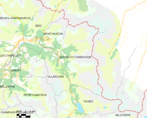
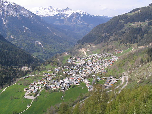
Sainte-Foy-Tarentaise
- коммуна во Франции
Hiking in Sainte-Foy-Tarentaise
Sainte-Foy-Tarentaise, located in the French Alps, is a fantastic destination for hiking enthusiasts. This region boasts stunning landscapes, diverse trails, and a variety of experiences for hikers of all levels. Here's what you can expect when hiking in Sainte-Foy-Tarentaise:...
- Страна:
- Почтовый код: 73640
- Координаты: 45° 35' 21" N, 6° 53' 2" E
- GPS треки (wikiloc): [Ссылка]
- Площадь: 100.15 кв.км
- Население: 737
- Веб сайт: [Ссылка]