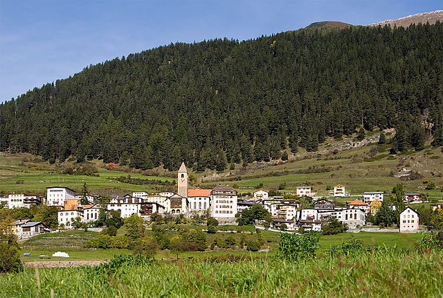
Пфундс (Pfunds, Pfunds)

 Hiking in Пфундс
Pfunds, a charming village located in the Tyrol region of Austria, is an excellent destination for hiking enthusiasts. Nestled in the picturesque Inn Valley, it serves as a gateway to numerous hiking trails that cater to different skill levels, from easy walks to challenging mountain hikes.
Hiking Highlights in Pfunds:
-
Scenic Trails:
- The area around Pfunds boasts a variety of scenic paths that offer stunning views of the surrounding mountains, valleys, and idyllic landscapes. Many trails are well-marked and maintained, making them accessible for hikers of all abilities.
-
Route Options:
- Easier Trails: For beginners or those looking for a leisurely hike, options such as the Pfunds Forest Trail provide a gentle introduction to the area’s natural beauty.
- Moderate Trails: The hike to the nearby village of Tösens or the trail around the beautiful Latschen Lake offers a moderate challenge with rewarding views.
- Challenging Hikes: For experienced hikers, routes that lead up into the higher elevations of the Ötztal Alps are available, providing breathtaking panoramas and a sense of adventure.
-
Seasonal Hiking:
- Each season in Pfunds offers unique hiking experiences. Spring and summer are ideal for enjoying lush greenery and blooming flowers, while autumn provides a spectacular display of autumn foliage. Winter hiking routes are also available, with some trails prepared for snowshoeing.
-
Wildlife and Flora:
- The region is rich in biodiversity. As you hike, you might encounter various wildlife, including deer and various bird species, as well as beautiful alpine flora.
-
Local Attractions:
- Besides hiking, Pfunds offers various cultural attractions, including charming old churches and traditional Tyrolean architecture, adding a cultural component to your hiking adventures.
-
Guided Tours:
- For those new to the area or looking for a deeper insight, several local guides offer organized hikes, which can enhance the experience by providing knowledge about the flora, fauna, and geography of the region.
Practical Tips:
- Weather Considerations: Always check the weather forecast before heading out, as conditions in the mountains can change rapidly.
- Gear: Wear appropriate hiking shoes and bring layers of clothing, sufficient water, and snacks. A map or GPS can be very helpful as well.
- Local Resources: Consider stopping by the local tourist office for updated trail information and recommendations.
Overall, hiking in Pfunds offers a wonderful blend of natural beauty and the opportunity to experience the charm of Tyrol. Whether you are a seasoned hiker or a novice, the trails around Pfunds can provide a memorable outdoor experience.
- Страна:

- Почтовый код: 6542
- Телефонный код: 05474
- Код автомобильного номера: LA
- Координаты: 46° 58' 0" N, 10° 33' 0" E


- GPS треки (wikiloc): [Ссылка]
- Высота над уровнем моря: 970 м m
- Площадь: 140.4 кв.км
- Население: 2602
- Веб сайт: http://www.pfunds.tirol.gv.at/
- Википедия русская: wiki(ru)
- Википедия английская: wiki(en)
- Википедия национальная: wiki(de)
- Хранилище Wikidata: Wikidata: Q700407
- Катеория в википедии: [Ссылка]
- код Freebase: [/m/02vx__6]
- код GeoNames: Альт: [2768905]
- код VIAF: Альт: [248539516]
- идентификатор местоположения ArchINFORM: [11246]
- код австрийского муниципалитета: [70617]
- код NKC: [ge997634]
- LIR: [1141]
Граничит с регионами:


Курон-Веноста
- коммуна Италии
Hiking in Курон-Веноста
Graun im Vinschgau, located in the beautiful Vinschgau Valley of South Tyrol, Italy, is a fantastic destination for hikers. Surrounded by stunning alpine scenery, including the Ortler Alps and the Texel Group Nature Park, it offers a variety of trails suitable for all skill levels. Here are some highlights and tips for hiking in this region:...
- Страна:

- Почтовый код: 39020
- Телефонный код: 0473
- Код автомобильного номера: BZ
- Координаты: 46° 48' 30" N, 10° 32' 34" E
- GPS треки (wikiloc): [Ссылка]
- Высота над уровнем моря: 1520 м m
- Площадь: 209.65 кв.км
- Население: 2381
- Веб сайт: [Ссылка]


Наудерс
Hiking in Наудерс
Nauders, located in the Tyrol region of Austria, is a fantastic destination for hiking enthusiasts. Nestled near the borders of Italy and Switzerland, it offers breathtaking alpine scenery, diverse trails, and a rich natural environment....
- Страна:
- Почтовый код: 6543
- Телефонный код: 0
- Код автомобильного номера: LA
- Координаты: 46° 52' 0" N, 10° 31' 0" E
- GPS треки (wikiloc): [Ссылка]
- Высота над уровнем моря: 1394 м m
- Площадь: 90.3 кв.км
- Население: 1542
- Веб сайт: [Ссылка]

Valsot
Hiking in Valsot
Valsot is a picturesque mountain area located in the Swiss Alps, renowned for its stunning landscapes and extensive network of hiking trails. Here’s an overview of what you can expect when hiking in Valsot:...
- Страна:

- Почтовый код: 7556, 7559
- Телефонный код: 081
- Код автомобильного номера: GR
- Координаты: 46° 50' 0" N, 10° 23' 0" E
- GPS треки (wikiloc): [Ссылка]
- Высота над уровнем моря: 1236 м m
- Площадь: 158.96 кв.км
- Население: 859
- Веб сайт: [Ссылка]