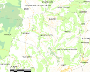
Кенсьё (Quincieu, Quincieu)

- коммуна во Франции
 Hiking in Кенсьё
Quincieu is not a widely recognized hiking destination in the usual lists of outdoor places, which might imply that you meant a specific region or perhaps there was a typo in the name. If you're referring to a specific area or local trail in a less popular region, I would recommend checking local hiking forums or resources for detailed information.
If you're looking for general advice on hiking in any area:
-
Research Trails: Look for maps and trail guides that show various hiking routes. Websites like AllTrails or local park service websites can provide insights into trail lengths, difficulty levels, and user reviews.
-
Pack Properly: Ensure you have suitable gear, such as appropriate footwear, enough water, snacks, first aid kits, and any necessary personal items.
-
Consider Weather Conditions: Always check the weather forecast before heading out. Dress in layers and be prepared for sudden changes in weather.
-
Leave No Trace: Follow the Leave No Trace principles to preserve nature and keep trails clean for future hikers.
-
Safety First: Inform someone about your hiking plans, carry a fully charged phone, and consider bringing a GPS device or a physical map, especially if you're hiking in remote areas.
If you have a different location in mind or want to know about a specific trail nearby, feel free to provide more details!
- Страна:

- Почтовый код: 38470
- Координаты: 45° 16' 32" N, 5° 23' 7" E


- GPS треки (wikiloc): [Ссылка]
- Площадь: 4.75 кв.км
- Население: 103
- Википедия русская: wiki(ru)
- Википедия английская: wiki(en)
- Википедия национальная: wiki(fr)
- Хранилище Wikidata: Wikidata: Q1068530
- Катеория в википедии: [Ссылка]
- код Freebase: [/m/03nvj98]
- код GeoNames: Альт: [6613664]
- номер SIREN: [213803307]
- код BNF: [152581411]
- код муниципалитета INSEE: 38330
Граничит с регионами:


Ватильё
- коммуна во Франции
Hiking in Ватильё
Vatilieu is a charming commune located in the Isère department in the Auvergne-Rhône-Alpes region of southeastern France. Although it may not be as widely known as other hiking destinations, the surrounding area offers beautiful landscapes and opportunities for outdoor activities like hiking....
- Страна:
- Почтовый код: 38470
- Координаты: 45° 15' 22" N, 5° 24' 38" E
- GPS треки (wikiloc): [Ссылка]
- Площадь: 9.22 кв.км
- Население: 370
- Веб сайт: [Ссылка]
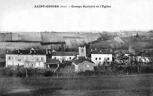

Сен-Жуар
- коммуна во Франции
Hiking in Сен-Жуар
Saint-Geoirs is a charming commune in the Isère department of the Auvergne-Rhône-Alpes region in southeastern France. While it's not as famous for hiking as some larger national parks or mountainous areas, there are still plenty of opportunities for outdoor enthusiasts to enjoy the natural surroundings....
- Страна:
- Почтовый код: 38590
- Координаты: 45° 19' 20" N, 5° 21' 17" E
- GPS треки (wikiloc): [Ссылка]
- Площадь: 6.93 кв.км
- Население: 523

Сен-Мишель-де-Сен-Жуар
- коммуна во Франции
Hiking in Сен-Мишель-де-Сен-Жуар
Saint-Michel-de-Saint-Geoirs is a small commune located in the Isère department of the Auvergne-Rhône-Alpes region in southeastern France. While it may not be as widely known as some larger hiking destinations, it offers a variety of outdoor activities in its natural surroundings, especially for those looking to explore the beautiful scenery of the region....
- Страна:
- Почтовый код: 38590
- Координаты: 45° 18' 19" N, 5° 21' 21" E
- GPS треки (wikiloc): [Ссылка]
- Площадь: 7.14 кв.км
- Население: 307
- Веб сайт: [Ссылка]
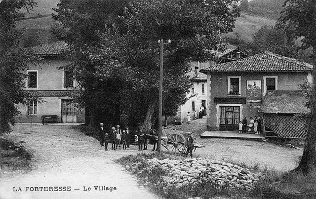
Ла-Фортрес
- коммуна во Франции
Hiking in Ла-Фортрес
La Forteresse, located in the Vosges Mountains of northeastern France, is a popular destination for hiking enthusiasts. The area is known for its stunning natural beauty, rich history, and diverse trails that cater to various skill levels. Here are some key points to consider when hiking in La Forteresse:...
- Страна:
- Почтовый код: 38590
- Координаты: 45° 17' 41" N, 5° 24' 13" E
- GPS треки (wikiloc): [Ссылка]
- Площадь: 9.22 кв.км
- Население: 324

Серр-Нерполь
- коммуна во Франции
Hiking in Серр-Нерполь
Serre-Nerpol, located in the French Alps, offers a range of hiking opportunities for enthusiasts of all skill levels. Here are some key highlights and tips for hiking in this beautiful region:...
- Страна:
- Почтовый код: 38470
- Координаты: 45° 15' 29" N, 5° 22' 30" E
- GPS треки (wikiloc): [Ссылка]
- Высота над уровнем моря: 400 м m
- Площадь: 13.16 кв.км
- Население: 293
- Веб сайт: [Ссылка]