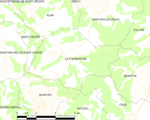
Сен-Жуар (Saint-Geoirs, Saint-Geoirs)

- коммуна во Франции
 Hiking in Сен-Жуар
Saint-Geoirs is a charming commune in the Isère department of the Auvergne-Rhône-Alpes region in southeastern France. While it's not as famous for hiking as some larger national parks or mountainous areas, there are still plenty of opportunities for outdoor enthusiasts to enjoy the natural surroundings.
Hiking Opportunities:
-
Local Trails: There are various local trails around Saint-Geoirs that cater to different skill levels. These may include gentle walks suitable for families as well as more challenging routes for experienced hikers.
-
Nearby Natural Areas: The surrounding area features beautiful landscapes with rolling hills, forests, and rivers. Exploring these areas can provide a sense of tranquility and the chance to immerse oneself in nature.
-
Vercors Regional Natural Park: A short drive away is the Vercors Regional Natural Park, which offers a plethora of hiking trails. The park is known for its stunning limestone cliffs, deep gorges, and diverse flora and fauna. Hiking here can range from easy paths suitable for leisurely walks to more challenging mountain hikes.
-
Chartreuse Mountains: Another nearby destination is the Chartreuse mountain range, which also offers a variety of trails. It’s perfect for those looking to explore dense forests, alpine meadows, and panoramic views.
Tips for Hiking in Saint-Geoirs:
- Trail Maps: Before heading out, obtain a map of the local trails. This can usually be found at local tourist offices or online.
- Weather Conditions: Check the weather forecast before your hike, as conditions can change quickly in mountainous regions.
- Gear: Wear sturdy hiking boots and bring essentials like water, snacks, sunscreen, and a first aid kit.
- Respect Nature: Follow Leave No Trace principles by staying on marked trails and taking all trash with you.
Conclusion:
While hiking directly in Saint-Geoirs may not offer extensive options, its proximity to larger natural landmarks allows for a delightful hiking experience in the beautiful Auvergne-Rhône-Alpes region. Whether you're looking for a casual day hike or a more challenging adventure, the surrounding areas will not disappoint. Enjoy your hiking adventure!
- Страна:

- Почтовый код: 38590
- Координаты: 45° 19' 20" N, 5° 21' 17" E


- GPS треки (wikiloc): [Ссылка]
- Площадь: 6.93 кв.км
- Население: 523
- Википедия русская: wiki(ru)
- Википедия английская: wiki(en)
- Википедия национальная: wiki(fr)
- Хранилище Wikidata: Wikidata: Q1067799
- Катеория в википедии: [Ссылка]
- код Freebase: [/m/03nvhdd]
- код GeoNames: Альт: [6454089]
- номер SIREN: [213803877]
- код BNF: [15258197n]
- код муниципалитета INSEE: 38387
Граничит с регионами:


Брион
Hiking in Брион
Brion, located in the Isère department of the Auvergne-Rhône-Alpes region in southeastern France, offers a variety of scenic hiking opportunities that showcase the natural beauty of the surrounding landscapes. Here are some key points to consider when hiking in Brion:...
- Страна:
- Почтовый код: 38590
- Координаты: 45° 17' 34" N, 5° 20' 18" E
- GPS треки (wikiloc): [Ссылка]
- Площадь: 3.94 кв.км
- Население: 138
- Веб сайт: [Ссылка]

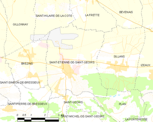
Сент-Этьенн-де-Сен-Жуар
- коммуна во Франции
Hiking in Сент-Этьенн-де-Сен-Жуар
Saint-Étienne-de-Saint-Geoirs, located in the Auvergne-Rhône-Alpes region of France, is surrounded by beautiful natural landscapes that are ideal for hiking enthusiasts. Here are some highlights and recommendations for hiking in this area:...
- Страна:
- Почтовый код: 38590
- Координаты: 45° 20' 20" N, 5° 20' 43" E
- GPS треки (wikiloc): [Ссылка]
- Площадь: 18.62 кв.км
- Население: 3259
- Веб сайт: [Ссылка]

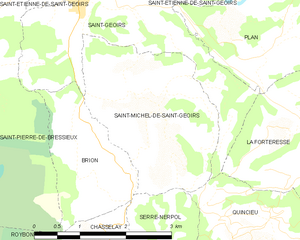
Сен-Мишель-де-Сен-Жуар
- коммуна во Франции
Hiking in Сен-Мишель-де-Сен-Жуар
Saint-Michel-de-Saint-Geoirs is a small commune located in the Isère department of the Auvergne-Rhône-Alpes region in southeastern France. While it may not be as widely known as some larger hiking destinations, it offers a variety of outdoor activities in its natural surroundings, especially for those looking to explore the beautiful scenery of the region....
- Страна:
- Почтовый код: 38590
- Координаты: 45° 18' 19" N, 5° 21' 21" E
- GPS треки (wikiloc): [Ссылка]
- Площадь: 7.14 кв.км
- Население: 307
- Веб сайт: [Ссылка]


Сен-Пьер-де-Бресьё
- коммуна во Франции
Hiking in Сен-Пьер-де-Бресьё
Saint-Pierre-de-Bressieux is a charming commune located in the Isère department of France, nestled in the picturesque region of Auvergne-Rhône-Alpes. Hiking around this area offers beautiful landscapes, varying terrains, and opportunities to explore the local flora and fauna....
- Страна:
- Почтовый код: 38870
- Координаты: 45° 18' 56" N, 5° 17' 7" E
- GPS треки (wikiloc): [Ссылка]
- Площадь: 23.08 кв.км
- Население: 766
- Веб сайт: [Ссылка]

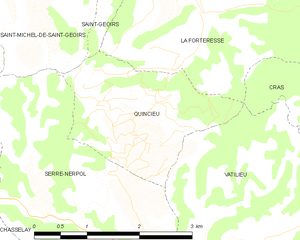
Кенсьё
- коммуна во Франции
Hiking in Кенсьё
Quincieu is not a widely recognized hiking destination in the usual lists of outdoor places, which might imply that you meant a specific region or perhaps there was a typo in the name. If you're referring to a specific area or local trail in a less popular region, I would recommend checking local hiking forums or resources for detailed information....
- Страна:
- Почтовый код: 38470
- Координаты: 45° 16' 32" N, 5° 23' 7" E
- GPS треки (wikiloc): [Ссылка]
- Площадь: 4.75 кв.км
- Население: 103


План
- коммуна во Франции
Hiking in План
Plan, located in the Isère department in the Auvergne-Rhône-Alpes region of France, is a fantastic area for hiking enthusiasts. The region is characterized by stunning natural beauty, including mountains, valleys, and rivers, making it an ideal destination for both casual walkers and experienced hikers. Here are some key aspects of hiking in and around Plan, Isère:...
- Страна:
- Почтовый код: 38590
- Координаты: 45° 18' 46" N, 5° 23' 33" E
- GPS треки (wikiloc): [Ссылка]
- Площадь: 6.1 кв.км
- Население: 256
- Веб сайт: [Ссылка]
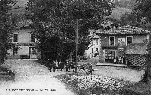
Ла-Фортрес
- коммуна во Франции
Hiking in Ла-Фортрес
La Forteresse, located in the Vosges Mountains of northeastern France, is a popular destination for hiking enthusiasts. The area is known for its stunning natural beauty, rich history, and diverse trails that cater to various skill levels. Here are some key points to consider when hiking in La Forteresse:...
- Страна:
- Почтовый код: 38590
- Координаты: 45° 17' 41" N, 5° 24' 13" E
- GPS треки (wikiloc): [Ссылка]
- Площадь: 9.22 кв.км
- Население: 324