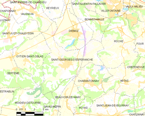
Рош (Roche, Roche)

- коммуна во Франции
 Hiking in Рош
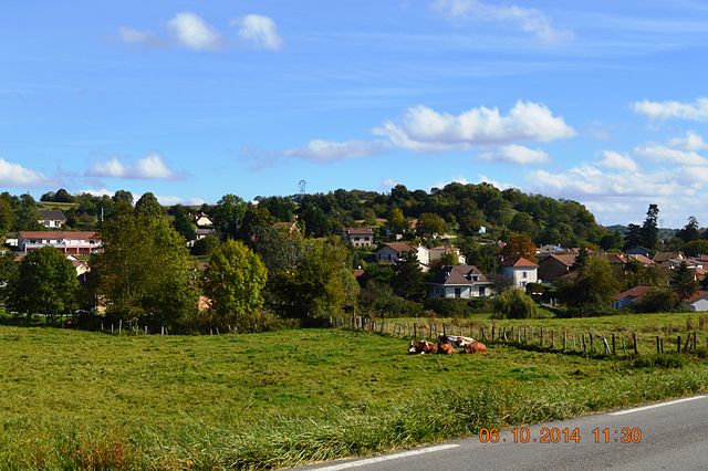
Roche, located in the Isère department of southeastern France, offers a variety of hiking opportunities in a stunning natural setting. The region is characterized by its beautiful mountains, valleys, and diverse landscapes, making it an excellent destination for hiking enthusiasts.
Hiking Trails:
-
Vercors Regional Natural Park: Not far from Roche, this park features numerous trails that vary in difficulty. You can explore limestone cliffs, dense forests, and panoramic viewpoints.
-
Belledonne Range: A bit further from Roche, the Belledonne mountain range offers challenging hikes for more experienced hikers. Trails here lead to high-altitude lakes and rugged terrain.
-
Local Trails: Within Roche itself, you can find local trails that provide a more accessible hiking experience. These trails often feature gentle slopes and scenic views, perfect for families or casual hikers.
Tips for Hiking in Roche:
- Seasonality: The best time to hike in this region is from late spring to early fall (May to October). During winter, some trails may be covered in snow and require specialized gear.
- Weather Preparedness: Always check the weather forecast before heading out, as conditions can change rapidly in mountainous areas.
- Trail Maps: Consider picking up a local trail map or using a hiking app to help navigate the numerous paths available in the area. Signage can vary, so having a reliable reference is helpful.
- Safety: Always inform someone of your hiking plans, carry adequate water, snacks, and a first-aid kit, and wear proper hiking footwear.
Experience and Nature:
As you hike around Roche, you can expect to see diverse flora and fauna, stunning geological formations, and possibly even wildlife such as deer, chamois, and various bird species. The tranquility of the region also provides a perfect escape into nature.
Conclusion:
Whether you're a novice hiker or an experienced mountaineer, Roche in Isère offers a variety of options to explore the beautiful landscapes and enjoy the outdoors. Remember to plan ahead and stay safe while enjoying the trails!
- Страна:

- Почтовый код: 38090
- Координаты: 45° 35' 20" N, 5° 9' 34" E


- GPS треки (wikiloc): [Ссылка]
- Высота над уровнем моря: 230 м m
- Площадь: 20.14 кв.км
- Население: 1926
- Веб сайт: http://www.roche38.fr
- Википедия русская: wiki(ru)
- Википедия английская: wiki(en)
- Википедия национальная: wiki(fr)
- Хранилище Wikidata: Wikidata: Q1068353
- Катеория в википедии: [Ссылка]
- код Freebase: [/m/03nvk_l]
- номер SIREN: [213803398]
- код BNF: [152581500]
- код муниципалитета INSEE: 38339
Граничит с регионами:


Бонфамий
- коммуна во Франции
Hiking in Бонфамий
Bonnefamille is a charming commune in the Isère department of southeastern France. While it may not be as widely recognized as some other hiking destinations, it offers beautiful landscapes and the opportunity to explore the natural beauty of the surrounding area....
- Страна:
- Почтовый код: 38090
- Координаты: 45° 35' 46" N, 5° 7' 49" E
- GPS треки (wikiloc): [Ссылка]
- Площадь: 9.43 кв.км
- Население: 1088
- Веб сайт: [Ссылка]


Вильфонтен
- коммуна во Франции
Hiking in Вильфонтен
Villefontaine, located in the Auvergne-Rhône-Alpes region of France, offers a variety of outdoor activities including hiking. The area is characterized by scenic landscapes, lush greenery, and proximity to the Chartreuse and Vercors mountains, which provide ample opportunities for hiking enthusiasts of all levels....
- Страна:
- Почтовый код: 38090
- Координаты: 45° 36' 48" N, 5° 8' 55" E
- GPS треки (wikiloc): [Ссылка]
- Площадь: 11.63 кв.км
- Население: 18891
- Веб сайт: [Ссылка]

Сен-Жорж-д'Эсперанш
- коммуна во Франции
Hiking in Сен-Жорж-д'Эсперанш
Saint-Georges-d'Espéranche is a charming commune located in the Isère department of the Auvergne-Rhône-Alpes region in southeastern France. While it may not be as widely known as some other hiking destinations in the region, it offers a range of outdoor activities and scenic landscapes that are perfect for hiking enthusiasts....
- Страна:
- Почтовый код: 38790
- Координаты: 45° 33' 21" N, 5° 4' 39" E
- GPS треки (wikiloc): [Ссылка]
- Площадь: 24.65 кв.км
- Население: 3321
- Веб сайт: [Ссылка]


Шарантонне
Hiking in Шарантонне
Charantonnay is a charming municipality located in the Auvergne-Rhône-Alpes region of France, which is known for its beautiful landscapes and outdoor activities. Although it's a smaller village, it offers access to some lovely hiking opportunities in the surrounding areas. Here are some key points to consider for hiking in and around Charantonnay:...
- Страна:
- Почтовый код: 38790
- Координаты: 45° 32' 13" N, 5° 6' 29" E
- GPS треки (wikiloc): [Ссылка]
- Площадь: 11 кв.км
- Население: 1853
- Веб сайт: [Ссылка]

Артас
- коммуна во Франции
Hiking in Артас
Artas, located in the Isère department of the Auvergne-Rhône-Alpes region in southeastern France, is known for its beautiful landscapes and diverse hiking opportunities. Though small, the area surrounding Artas features a variety of trails that cater to different levels of hikers, from beginners to more experienced mountain trekkers....
- Страна:
- Почтовый код: 38440
- Координаты: 45° 32' 7" N, 5° 9' 52" E
- GPS треки (wikiloc): [Ссылка]
- Площадь: 14.15 кв.км
- Население: 1817
- Веб сайт: [Ссылка]


Фур
- коммуна во Франции
Hiking in Фур
Four is a small village in the Isère department in the Auvergne-Rhône-Alpes region of southeastern France. While it may not be as well known as some of its neighboring areas, it provides a great opportunity for hiking enthusiasts to explore the beautiful scenery of the French Alps....
- Страна:
- Почтовый код: 38080
- Координаты: 45° 35' 14" N, 5° 11' 44" E
- GPS треки (wikiloc): [Ссылка]
- Площадь: 11.82 кв.км
- Население: 1434
- Веб сайт: [Ссылка]