Артас (Artas, Artas)

- коммуна во Франции
 Hiking in Артас
Artas, located in the Isère department of the Auvergne-Rhône-Alpes region in southeastern France, is known for its beautiful landscapes and diverse hiking opportunities. Though small, the area surrounding Artas features a variety of trails that cater to different levels of hikers, from beginners to more experienced mountain trekkers.
Hiking Highlights in Artas
-
Scenic Views: The region often offers breathtaking views of the surrounding Alps and charming rural landscapes. Keep your camera ready for stunning panoramas, particularly during sunset or sunrise.
-
Variety of Trails: There are numerous trails in and around Artas, ranging from easy walks through picturesque countryside to more challenging hikes that take you into the foothills of the Alps. Trails can often be accessed directly from the village.
-
Flora and Fauna: As you hike, you might encounter diverse flora ranging from meadows adorned with wildflowers to dense forests. Wildlife spotting is also possible, with opportunities to see local birds and small mammals.
-
Historical Sites: Some hikes may lead you past historical landmarks, including ancient chapels and ruins, providing a glimpse into the region’s heritage and culture.
-
Local Amenities: After a day of hiking, Artas has local amenities such as cafes and restaurants where you can enjoy traditional French cuisine or relax with a drink.
Tips for Hiking in Artas
-
Check the Weather: Conditions in the Alps can change rapidly, so it's essential to check the weather forecast and prepare accordingly.
-
Wear Proper Gear: Good hiking boots, comfortable clothing, and a backpack with essentials such as water, snacks, a first-aid kit, and a map or GPS are crucial for a safe and enjoyable hike.
-
Respect Nature: Follow Leave No Trace principles to minimize your impact on the environment. Stick to marked paths and avoid disturbing wildlife.
-
Start Early: If you plan on taking longer hikes, starting early can help you avoid the afternoon heat and give you ample time to complete your hike.
-
Local Guides: If you're unfamiliar with the area, consider hiring a local guide. They can provide valuable insight and ensure you get the most out of your hiking experience.
Overall, hiking in Artas, Isère, offers a lovely balance of nature, scenery, and culture, making it an enjoyable destination for hikers of all levels.
- Страна:

- Почтовый код: 38440
- Координаты: 45° 32' 7" N, 5° 9' 52" E


- GPS треки (wikiloc): [Ссылка]
- Площадь: 14.15 кв.км
- Население: 1817
- Веб сайт: http://www.artas-mairie.fr
- Википедия русская: wiki(ru)
- Википедия английская: wiki(en)
- Википедия национальная: wiki(fr)
- Хранилище Wikidata: Wikidata: Q510449
- Катеория в википедии: [Ссылка]
- код Freebase: [/m/03g_7ld]
- код GeoNames: Альт: [6448713]
- номер SIREN: [213800154]
- код BNF: [15257844r]
- код VIAF: Альт: [165393146]
- код GND: Альт: [4499868-5]
- код LCNAF: Альт: [n82110111]
- код муниципалитета INSEE: 38015
Граничит с регионами:

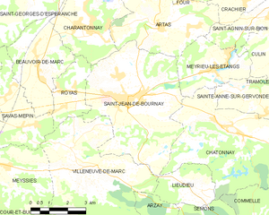
Сен-Жан-де-Бурне
- коммуна во Франции
Hiking in Сен-Жан-де-Бурне
Saint-Jean-de-Bournay is a charming commune located in the Isère department of the Auvergne-Rhône-Alpes region in southeastern France. The surrounding area is characterized by diverse landscapes, including low valleys, rolling hills, and scenic views, making it a great destination for hiking enthusiasts....
- Страна:
- Почтовый код: 38440
- Координаты: 45° 30' 8" N, 5° 8' 16" E
- GPS треки (wikiloc): [Ссылка]
- Площадь: 26.87 кв.км
- Население: 4622
- Веб сайт: [Ссылка]

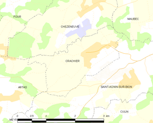
Крашье
- коммуна во Франции
Hiking in Крашье
Crachier, though not widely known, may refer to hiking areas in regions with picturesque landscapes and trails. If you're interested in a specific location with that name or similar sounding places, I could help you explore general hiking tips and information about various renowned hiking spots....
- Страна:
- Почтовый код: 38300
- Координаты: 45° 32' 54" N, 5° 13' 32" E
- GPS треки (wikiloc): [Ссылка]
- Площадь: 3.64 кв.км
- Население: 494


Сент-Аньен-сюр-Бьон
- коммуна во Франции
Hiking in Сент-Аньен-сюр-Бьон
Saint-Agnin-sur-Bion is a small commune located in the Auvergne-Rhône-Alpes region of France, known for its beautiful natural landscapes and opportunities for outdoor activities, including hiking....
- Страна:
- Почтовый код: 38300
- Координаты: 45° 32' 26" N, 5° 14' 39" E
- GPS треки (wikiloc): [Ссылка]
- Площадь: 9.7 кв.км
- Население: 993
- Веб сайт: [Ссылка]


Рош
- коммуна во Франции
Hiking in Рош
Roche, located in the Isère department of southeastern France, offers a variety of hiking opportunities in a stunning natural setting. The region is characterized by its beautiful mountains, valleys, and diverse landscapes, making it an excellent destination for hiking enthusiasts....
- Страна:
- Почтовый код: 38090
- Координаты: 45° 35' 20" N, 5° 9' 34" E
- GPS треки (wikiloc): [Ссылка]
- Высота над уровнем моря: 230 м m
- Площадь: 20.14 кв.км
- Население: 1926
- Веб сайт: [Ссылка]


Шарантонне
Hiking in Шарантонне
Charantonnay is a charming municipality located in the Auvergne-Rhône-Alpes region of France, which is known for its beautiful landscapes and outdoor activities. Although it's a smaller village, it offers access to some lovely hiking opportunities in the surrounding areas. Here are some key points to consider for hiking in and around Charantonnay:...
- Страна:
- Почтовый код: 38790
- Координаты: 45° 32' 13" N, 5° 6' 29" E
- GPS треки (wikiloc): [Ссылка]
- Площадь: 11 кв.км
- Население: 1853
- Веб сайт: [Ссылка]

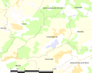
Шезнёв
- коммуна во Франции
Hiking in Шезнёв
Chèzeneuve is a charming area located in the Auvergne-Rhône-Alpes region of France, known for its beautiful landscapes, rolling hills, and outdoor activities, including hiking. The region provides a range of hiking trails suitable for various skill levels, from gentle strolls to more challenging treks....
- Страна:
- Почтовый код: 38300
- Координаты: 45° 33' 44" N, 5° 13' 24" E
- GPS треки (wikiloc): [Ссылка]
- Площадь: 6.79 кв.км
- Население: 550


Фур
- коммуна во Франции
Hiking in Фур
Four is a small village in the Isère department in the Auvergne-Rhône-Alpes region of southeastern France. While it may not be as well known as some of its neighboring areas, it provides a great opportunity for hiking enthusiasts to explore the beautiful scenery of the French Alps....
- Страна:
- Почтовый код: 38080
- Координаты: 45° 35' 14" N, 5° 11' 44" E
- GPS треки (wikiloc): [Ссылка]
- Площадь: 11.82 кв.км
- Население: 1434
- Веб сайт: [Ссылка]

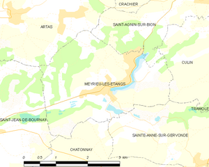
Мерье-лез-Этан
- коммуна во Франции
Hiking in Мерье-лез-Этан
Meyrieu-les-Étangs is a charming commune located in the Auvergne-Rhône-Alpes region of France. Nestled in a rural setting, it offers several opportunities for hiking enthusiasts to enjoy nature and exploration....
- Страна:
- Почтовый код: 38440
- Координаты: 45° 30' 49" N, 5° 12' 0" E
- GPS треки (wikiloc): [Ссылка]
- Высота над уровнем моря: 390 м m
- Площадь: 8.54 кв.км
- Население: 969
- Веб сайт: [Ссылка]