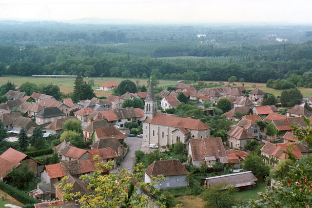
Saint-Benoît (Saint-Benoît)
- коммуна во Франции
 Hiking in Saint-Benoît
Saint-Benoît, located in the Ain department of France, offers a picturesque setting for hiking enthusiasts. Nestled in the foothills of the Jura Mountains, the area features a mix of lush forests, rolling hills, and stunning views of the surrounding landscape, making it an ideal location for both casual walkers and experienced hikers.
Hiking Trails
-
Sentier des Côtes: This popular trail takes you through beautiful countryside and offers fantastic views of the region. The trail is well-marked and varies in difficulty, suitable for most skill levels.
-
Le Mont Myon: For those looking for a challenge, the hike to Mont Myon provides a rewarding experience with a more strenuous ascent. Once at the summit, hikers can enjoy panoramic views that are particularly breathtaking during sunrise or sunset.
-
Forest Trails: The surrounding forests offer many smaller, interconnected trails that can be explored for a more casual hike. These paths provide a serene environment, perfect for nature lovers and birdwatchers.
Flora and Fauna
The region around Saint-Benoît is rich in biodiversity. Hikers may encounter various plant species, including wildflowers in spring and diverse tree species. Wildlife such as deer, foxes, and numerous bird species can also be spotted, making it a great location for nature observation.
Best Times to Hike
The ideal times for hiking in Saint-Benoît are during spring (March to June) and fall (September to November) when the weather is mild, and the landscapes are particularly vibrant. Summer can be quite warm, while winter might see snow in the higher elevations, affecting trail accessibility.
Safety Tips
- Always check the weather forecasts before heading out.
- Wear appropriate hiking gear, including sturdy footwear and layered clothing.
- Bring plenty of water and snacks, especially for longer hikes.
- Let someone know your hiking plans and estimated return time.
Local Amenities
Saint-Benoît and the surrounding area offer several accommodation options, including hotels, gîtes, and campgrounds for those wanting to extend their stay. There are also local eateries where you can enjoy traditional French cuisine after a day on the trails.
Overall, hiking in Saint-Benoît provides a combination of natural beauty, diverse landscapes, and a peaceful environment, making it a worthwhile destination for outdoor enthusiasts.
- Страна:

- Почтовый код: 01300
- Координаты: 45° 41' 40" N, 5° 35' 19" E


- GPS треки (wikiloc): [Ссылка]
- Площадь: 21.65 кв.км
- Население: 833
- Википедия английская: wiki(en)
- Википедия национальная: wiki(fr)
- Хранилище Wikidata: Wikidata: Q683710
- Катеория в википедии: [Ссылка]
- Карты в википедии: [Ссылка]
- код Freebase: [/m/081qm0]
- код Freebase: [/m/081qm0]
- код муниципалитета INSEE: 01338
- код муниципалитета INSEE: 01338
Граничит с регионами:


Бранг
Hiking in Бранг
Brangues is a charming village located in the Isère department of the Auvergne-Rhône-Alpes region in southeastern France. It's situated near the stunning Vercors Regional Natural Park, which offers a variety of hiking trails that cater to different skill levels....
- Страна:
- Почтовый код: 38510
- Координаты: 45° 41' 35" N, 5° 31' 52" E
- GPS треки (wikiloc): [Ссылка]
- Площадь: 11.67 кв.км
- Население: 616
- Веб сайт: [Ссылка]


Ле-Бушаж
Hiking in Ле-Бушаж
Le Bouchage is a small commune located in the Isère department of the Auvergne-Rhône-Alpes region in southeastern France. While it might not be as well-known as some of the larger towns and national parks in the area, it offers a charming landscape that can appeal to hikers looking for quieter trails and scenic views....
- Страна:
- Почтовый код: 38510
- Координаты: 45° 40' 13" N, 5° 31' 33" E
- GPS треки (wikiloc): [Ссылка]
- Площадь: 11.2 кв.км
- Население: 625
- Веб сайт: [Ссылка]
Бренье-Кордон
- коммуна во Франции
Hiking in Бренье-Кордон
Brégnier-Cordon is a charming village located in the Auvergne-Rhône-Alpes region of France, surrounded by stunning natural landscapes, making it an excellent destination for hiking enthusiasts. Here are some key points to consider when hiking in and around Brégnier-Cordon:...
- Страна:
- Почтовый код: 01300
- Координаты: 45° 38' 56" N, 5° 37' 11" E
- GPS треки (wikiloc): [Ссылка]
- Площадь: 11 кв.км
- Население: 856
- Веб сайт: [Ссылка]

Конзьё
- коммуна во Франции
Hiking in Конзьё
Conzieu is a small village located in the Ain department of the Auvergne-Rhône-Alpes region in France. While it may not be as widely known as some other hiking destinations in the Alps, it offers various opportunities for nature lovers and hikers to explore its beautiful landscapes....
- Страна:
- Почтовый код: 01300
- Координаты: 45° 43' 34" N, 5° 36' 26" E
- GPS треки (wikiloc): [Ссылка]
- Площадь: 7.2 кв.км
- Население: 146


Лез-Авеньер
- коммуна во Франции
Hiking in Лез-Авеньер
Les Avenières is a beautiful region located in the Auvergne-Rhône-Alpes region of France, known for its diverse landscapes, charming villages, and proximity to the Chartreuse Mountains. The area offers a variety of hiking options, catering to different skill levels and preferences....
- Страна:
- Почтовый код: 38630
- Координаты: 45° 38' 9" N, 5° 33' 48" E
- GPS треки (wikiloc): [Ссылка]
- Площадь: 30 кв.км
- Население: 5615
- Веб сайт: [Ссылка]

Сен-Бенуа
- коммуна во Франции
Hiking in Сен-Бенуа
Saint-Bois is a small village located in the Vosges department in northeastern France. While it may not be as widely known as some other hiking destinations, the surrounding areas offer beautiful landscapes and a variety of trails that cater to hikers of all skill levels....
- Страна:
- Почтовый код: 01300
- Координаты: 45° 41' 58" N, 5° 38' 7" E
- GPS треки (wikiloc): [Ссылка]
- Площадь: 9.42 кв.км
- Население: 146

Гроле
- коммуна во Франции
Hiking in Гроле
Groslée is a charming municipality located in the Auvergne-Rhône-Alpes region of France, nestled within the breathtaking landscapes of the French Alps. Hiking in this area offers a wonderful opportunity to explore scenic vistas, lush forests, and a variety of terrains....
- Страна:
- Почтовый код: 01680
- Координаты: 45° 42' 46" N, 5° 34' 0" E
- GPS треки (wikiloc): [Ссылка]
- Площадь: 7.27 кв.км
- Население: 360

Премейзель
- коммуна во Франции
Hiking in Премейзель
Prémeyzel is a charming Alpine village located in the Canton of Vaud, Switzerland. It's positioned at an altitude of approximately 1,300 meters (4,265 feet), nestled in the Jura Mountains, which makes it a great spot for hiking enthusiasts. Here are some key aspects to consider when hiking in and around Prémeyzel:...
- Страна:
- Почтовый код: 01300
- Координаты: 45° 41' 2" N, 5° 38' 53" E
- GPS треки (wikiloc): [Ссылка]
- Площадь: 7.63 кв.км
- Население: 238
- Веб сайт: [Ссылка]