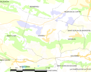
Сен-Шеф (Saint-Chef, Saint-Chef)

- коммуна во Франции
 Hiking in Сен-Шеф
Saint-Chef is a charming commune located in the Isère department of the Auvergne-Rhône-Alpes region in southeastern France. The area is known for its beautiful landscapes, rolling hills, and rich natural surroundings, making it an attractive destination for hikers of all levels.
Hiking Opportunities
-
Trails: Saint-Chef and its surrounding areas offer several marked hiking trails. These trails range from easy walks suitable for families to more challenging routes for experienced hikers. The terrain varies from flat paths to hilly landscapes, providing a diverse hiking experience.
-
Natural Beauty: The region boasts picturesque views, including distant mountains, fields, and forests. It is particularly stunning during spring and autumn when the flora is vibrant. Look out for local wildlife and unique plants along the trails.
-
Heritage Sites: While hiking, you may encounter various historical landmarks and sites, such as ancient churches or traditional farms, that give insight into the area's culture and heritage.
-
Nearby Parks: Just a short drive from Saint-Chef, you’ll find the Rhône-Alpes regional parks that offer extensive hiking networks. The Vercors Regional Natural Park and the Chartreuse Mountains are notable options for day trips.
-
Local Guides: If you are unfamiliar with the area, consider hiring a local guide or joining a hiking group. They can provide valuable insights about the terrain, flora and fauna, and history of the region.
Preparations
- Gear: Ensure you have appropriate hiking gear, including sturdy shoes, weather-appropriate clothing, and a day pack with essentials like water, snacks, and a map or GPS device.
- Weather: Check the weather conditions before heading out, as the weather can change rapidly in mountainous regions.
- Safety: Familiarize yourself with the trails and their difficulty levels. Always let someone know your hiking plans and expected return time.
Conclusion
Hiking in Saint-Chef offers a wonderful opportunity to immerse yourself in nature while enjoying the serene beauty and cultural richness of the region. Whether you are a casual walker or an experienced hiker, there's something for everyone. Enjoy your adventure!
- Страна:

- Почтовый код: 38890
- Координаты: 45° 38' 2" N, 5° 21' 57" E


- GPS треки (wikiloc): [Ссылка]
- Площадь: 27.16 кв.км
- Население: 3620
- Веб сайт: http://www.saint-chef.fr
- Википедия русская: wiki(ru)
- Википедия английская: wiki(en)
- Википедия национальная: wiki(fr)
- Хранилище Wikidata: Wikidata: Q960827
- Катеория в википедии: [Ссылка]
- код Freebase: [/m/03nvj65]
- код GeoNames: Альт: [2981195]
- номер SIREN: [213803745]
- код BNF: [152581849]
- код VIAF: Альт: [157262522]
- код муниципалитета INSEE: 38374
Граничит с регионами:

Виньё
- коммуна во Франции
Hiking in Виньё
Vignieu is a charming commune located in the Isère department in the Auvergne-Rhône-Alpes region of southeastern France. While it might not be as well-known as some other hiking destinations in France, it offers picturesque landscapes and a range of outdoor activities that can cater to hikers of various skill levels....
- Страна:
- Почтовый код: 38890
- Координаты: 45° 37' 41" N, 5° 25' 29" E
- GPS треки (wikiloc): [Ссылка]
- Площадь: 9.4 кв.км
- Население: 1033
- Веб сайт: [Ссылка]


Сермерьё
- коммуна во Франции
Hiking in Сермерьё
Sermérieu is a small commune located in the Isère department of southeastern France. Nestled in a picturesque part of the Rhône-Alpes region, it offers several opportunities for hiking and enjoying the outdoors. Here are some things to know about hiking in and around Sermérieu:...
- Страна:
- Почтовый код: 38510
- Координаты: 45° 40' 17" N, 5° 24' 35" E
- GPS треки (wikiloc): [Ссылка]
- Площадь: 17.14 кв.км
- Население: 1640
- Веб сайт: [Ссылка]


Треп
- коммуна во Франции
Hiking in Треп
Trept is a scenic area located in the eastern part of Germany, particularly known for its beautiful landscapes and walking trails. While it may not be as famous as some other hiking destinations in Germany, there are still plenty of opportunities for outdoor enthusiasts to explore nature and enjoy some hiking....
- Страна:
- Почтовый код: 38460
- Координаты: 45° 41' 12" N, 5° 19' 12" E
- GPS треки (wikiloc): [Ссылка]
- Площадь: 15.87 кв.км
- Население: 2024
- Веб сайт: [Ссылка]


Саланьон
- коммуна во Франции
Hiking in Саланьон
Salagnon is a beautiful area for hiking, with its picturesque landscapes and variety of trails. While specific trail information may vary, here are some general tips and insights for hiking in Salagnon:...
- Страна:
- Почтовый код: 38890
- Координаты: 45° 40' 1" N, 5° 21' 18" E
- GPS треки (wikiloc): [Ссылка]
- Площадь: 8.21 кв.км
- Население: 1331
- Веб сайт: [Ссылка]


Сент-Илер-де-Бран
- коммуна во Франции
Hiking in Сент-Илер-де-Бран
Saint-Hilaire-de-Brens, located in the Auvergne-Rhône-Alpes region of France, is a small commune that offers a charming backdrop for hikers. The area is characterized by its beautiful landscapes, including gentle hills, rural countryside, and panoramic views....
- Страна:
- Почтовый код: 38460
- Координаты: 45° 40' 20" N, 5° 17' 28" E
- GPS треки (wikiloc): [Ссылка]
- Площадь: 7.52 кв.км
- Население: 608

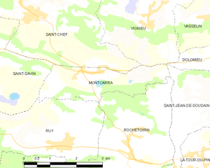
Монкарра
- коммуна во Франции
Hiking in Монкарра
Montcarra, located in the Isère department of southeastern France, is a beautiful area known for its scenic landscapes and outdoor activities. While it may not be as widely recognized as some of the larger national parks in the Alps, it offers a variety of hiking opportunities that can cater to different skill levels and preferences....
- Страна:
- Почтовый код: 38890
- Координаты: 45° 36' 47" N, 5° 23' 29" E
- GPS треки (wikiloc): [Ссылка]
- Площадь: 4.9 кв.км
- Население: 519
- Веб сайт: [Ссылка]


Сен-Савен
Hiking in Сен-Савен
Saint-Savin, located in the Isère department of the Auvergne-Rhône-Alpes region of France, is a charming village known for its natural beauty and access to various hiking trails. The area features stunning landscapes, rolling hills, and proximity to the Chartreuse and Vercors mountain ranges, making it a great destination for outdoor enthusiasts....
- Страна:
- Почтовый код: 38300
- Координаты: 45° 37' 43" N, 5° 18' 22" E
- GPS треки (wikiloc): [Ссылка]
- Площадь: 24.55 кв.км
- Население: 3967
- Веб сайт: [Ссылка]