Сен-Кристоф-ан-Уазан (Saint-Christophe-en-Oisans, Saint-Christophe-en-Oisans)

- коммуна во Франции
 Hiking in Сен-Кристоф-ан-Уазан
Saint-Christophe-en-Oisans is a charming village located in the French Alps, nestled within the Oisans valley. It serves as a gateway to some stunning hiking opportunities in the surrounding terrain, known for its breathtaking scenery, diverse ecosystems, and the proximity to the Écrins National Park.
Hiking Opportunities
-
Trails and Difficulty Levels:
- The area boasts a variety of trails suitable for different skill levels, from easy, family-friendly hikes to more challenging routes for seasoned hikers.
- Popular trails include those leading to high-altitude lakes, mountain passes, and scenic viewpoints. One notable hike is to the Lac du Lama, which offers stunning views of the surrounding peaks.
-
Écrins National Park:
- Just a short distance from Saint-Christophe, the park is home to numerous well-marked trails that traverse through alpine meadows, dense forests, and rugged mountain terrain.
- Look for trails such as the Refuge de l'Olan, where hikers can experience the majestic beauty of the glaciers and alpine flora.
-
Seasonal Considerations:
- Spring and summer are ideal for hiking, with trails typically becoming accessible around mid-June, depending on snow conditions. Fall hikes offer beautiful autumn foliage but may come with cooler temperatures.
- Winter hiking may also be possible in some areas, though proper equipment (like snow shoes or crampons) may be required.
Tips for Hiking in Saint-Christophe-en-Oisans
- Preparation: Always check the weather conditions before heading out and dress in layers. The weather in the mountains can change rapidly.
- Start Early: To make the most of your day and avoid afternoon storms, aim to start your hikes early in the morning.
- Stay Hydrated and Fueled: Bring plenty of water and snacks to keep your energy levels up.
- Maps and Navigation: Carry a detailed map or a GPS device, as some trails may not be well-marked.
- Safety First: Inform someone of your hiking plans and estimated return time. Consider hiking with a partner or group, especially on more remote trails.
Wildlife and Flora
While hiking, you may encounter a range of wildlife, including chamois, marmots, and various bird species. The unique flora of the region includes vibrant alpine flowers during the summer months, making for a picturesque hiking experience.
Conclusion
Hiking in Saint-Christophe-en-Oisans offers a mixture of adventure, natural beauty, and tranquility. Whether you are looking for a leisurely stroll or an exhilarating mountain ascent, the region has something for everyone. Always remember to respect the natural environment by following Leave No Trace principles and enjoying the stunning landscapes responsibly.
- Страна:

- Почтовый код: 38520
- Координаты: 44° 57' 26" N, 6° 10' 37" E


- GPS треки (wikiloc): [Ссылка]
- Площадь: 123.5 кв.км
- Население: 105
- Веб сайт: http://www.mairie-st-christophe-en-oisans.fr
- Википедия русская: wiki(ru)
- Википедия английская: wiki(en)
- Википедия национальная: wiki(fr)
- Хранилище Wikidata: Wikidata: Q741602
- Катеория в википедии: [Ссылка]
- код Freebase: [/m/03g_1kh]
- код GeoNames: Альт: [6433332]
- номер SIREN: [213803752]
- код BNF: [15258185n]
- код VIAF: Альт: [123244351]
- код LCNAF: Альт: [n86871636]
- код муниципалитета INSEE: 38375
Граничит с регионами:

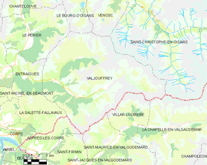
Вальжуффре
- коммуна во Франции
Hiking in Вальжуффре
Valjouffrey is a beautiful and lesser-known hiking destination located in the Isère department of the Auvergne-Rhône-Alpes region in France. Nestled in the heart of the Vercors Massif, Valjouffrey offers stunning landscapes characterized by dramatic peaks, lush valleys, and serene alpine lakes, making it a perfect spot for outdoor enthusiasts....
- Страна:
- Почтовый код: 38740
- Координаты: 44° 52' 20" N, 6° 1' 52" E
- GPS треки (wikiloc): [Ссылка]
- Высота над уровнем моря: 1014 м m
- Площадь: 72.56 кв.км
- Население: 145
- Веб сайт: [Ссылка]

Виллар-д’Арен
- коммуна во Франции
Hiking in Виллар-д’Арен
Villar-d'Arêne is a charming village located in the Écrins National Park in the French Alps, known for its stunning natural beauty and a variety of hiking opportunities. Here are some key aspects of hiking in this area:...
- Страна:
- Почтовый код: 05480
- Координаты: 45° 2' 34" N, 6° 20' 13" E
- GPS треки (wikiloc): [Ссылка]
- Площадь: 77.51 кв.км
- Население: 330
- Веб сайт: [Ссылка]

Вальлуиз
- коммуна во Франции
Hiking in Вальлуиз
Vallouise, located in the French Alps within the Ecrins National Park, is a stunning destination for hiking enthusiasts. The area is renowned for its breathtaking mountain landscapes, diverse ecosystems, and a variety of trails suitable for all levels of hikers....
- Страна:
- Почтовый код: 05290
- Координаты: 44° 50' 42" N, 6° 29' 13" E
- GPS треки (wikiloc): [Ссылка]
- Площадь: 68.58 кв.км
- Население: 758

Пельву
- коммуна во Франции
Hiking in Пельву
Pelvoux is a beautiful region located in the French Alps, specifically in the Ecrins National Park. It's known for its stunning mountain landscapes, varied hiking trails, and breathtaking views. Here are some key points to keep in mind when planning a hiking trip to Pelvoux:...
- Страна:
- Почтовый код: 05340
- Координаты: 44° 52' 9" N, 6° 29' 12" E
- GPS треки (wikiloc): [Ссылка]
- Площадь: 76.23 кв.км
- Население: 483

Мон-де-Лан
- коммуна во Франции
Hiking in Мон-де-Лан
Mont-de-Lans, located in the French Alps, is a scenic area that offers a variety of hiking opportunities for all levels of hikers. Situated near the famous ski resort of Les Deux Alpes, it transforms into a hiker’s paradise during the warmer months, showcasing stunning alpine landscapes, breathtaking views, and diverse flora and fauna....
- Страна:
- Почтовый код: 38860
- Координаты: 45° 2' 9" N, 6° 7' 44" E
- GPS треки (wikiloc): [Ссылка]
- Площадь: 31.66 кв.км
- Население: 1129
- Веб сайт: [Ссылка]


Веноск
- коммуна во Франции
Hiking in Веноск
Vénosc is a charming mountain village located in the French Alps, near the popular ski resort of Les Deux Alpes in the Isère department. The area offers a variety of hiking opportunities that cater to different skill levels, from leisurely walks to challenging mountain trails. Here are some highlights of hiking in Vénosc:...
- Страна:
- Почтовый код: 38520
- Координаты: 44° 59' 24" N, 6° 6' 56" E
- GPS треки (wikiloc): [Ссылка]
- Площадь: 25.06 кв.км
- Население: 765
- Веб сайт: [Ссылка]

Ла-Шапель-ан-Вальгодемар
- коммуна во Франции
Hiking in Ла-Шапель-ан-Вальгодемар
La Chapelle-en-Valgaudémar is a picturesque village located in the heart of the Écrins National Park in the French Alps. This area is renowned for its stunning natural beauty, rugged mountains, and a variety of hiking trails suitable for different skill levels....
- Страна:
- Почтовый код: 05800
- Координаты: 44° 49' 1" N, 6° 11' 41" E
- GPS треки (wikiloc): [Ссылка]
- Высота над уровнем моря: 1050 м m
- Площадь: 108.02 кв.км
- Население: 101

Ла-Грав
- коммуна во Франции
Hiking in Ла-Грав
La Grave is a stunning area located in the French Alps, known for its breathtaking mountain scenery and varied hiking opportunities. Here are some key points to consider if you're planning a hiking trip in La Grave:...
- Страна:
- Почтовый код: 05320
- Координаты: 45° 2' 46" N, 6° 18' 21" E
- GPS треки (wikiloc): [Ссылка]
- Площадь: 126.91 кв.км
- Население: 487
- Веб сайт: [Ссылка]