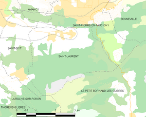
Saint-Pierre-en-Faucigny (Saint-Pierre-en-Faucigny)

- коммуна во Франции
 Hiking in Saint-Pierre-en-Faucigny
Saint-Pierre-en-Faucigny is a picturesque commune located in the Haute-Savoie region of France, nestled in the foothills of the French Alps. The area is known for its stunning natural beauty, making it an excellent destination for hiking enthusiasts.
Hiking Opportunities
-
Scenic Trails: The region offers a variety of hiking trails that cater to different skill levels, ranging from easy walks to challenging mountain hikes. The trails often provide breathtaking views of the surrounding mountains and valleys.
-
Nearby Mountains: Saint-Pierre-en-Faucigny is close to several mountain ranges, including the Bornes massif and the Aravis mountains. These areas have well-marked trails that lead to beautiful viewpoints, alpine lakes, and charming mountain villages.
-
Flora and Fauna: The region is rich in biodiversity, and hikers can enjoy encounters with a variety of plants and animals. In spring and summer, you can see wildflowers in bloom and possibly spot wildlife such as chamois, marmots, and various bird species.
-
Local Parks: The nearby natural parks, such as the Regional Natural Park of the Massif des Bauges, offer organized trails that are well-maintained and provide educational information about the local ecology.
Tips for Hiking in Saint-Pierre-en-Faucigny
-
Weather Awareness: The weather in the Alps can change quickly, so it’s essential to check forecasts before heading out and be prepared for sudden changes, especially at higher altitudes.
-
Proper Gear: Wear appropriate hiking boots and clothing. Always carry water, snacks, a map or GPS, and a first-aid kit.
-
Trail Etiquette: Respect local wildlife and stay on marked trails to minimize your impact on the environment.
-
Local Guides: If you're unfamiliar with the area, consider hiring a local guide who can enhance your hiking experience with knowledge of the terrain and culture.
Saint-Pierre-en-Faucigny serves as a fantastic base for hikers exploring the beautiful landscapes of the French Alps, and it offers plenty of opportunities for both novice and experienced hikers seeking adventure in nature.
- Страна:

- Почтовый код: 74800
- Координаты: 46° 3' 35" N, 6° 22' 21" E


- GPS треки (wikiloc): [Ссылка]
- Площадь: 14.91 кв.км
- Население: 6241
- Веб сайт: http://www.saintpierreenfaucigny.com
- Википедия английская: wiki(en)
- Википедия национальная: wiki(fr)
- Хранилище Wikidata: Wikidata: Q519495
- Катеория в википедии: [Ссылка]
- код Freebase: [/m/03ntxlx]
- код GeoNames: Альт: [6617613]
- номер SIREN: [217402502]
- код BNF: [15274504c]
- код VIAF: Альт: [249440994]
- код муниципалитета INSEE: 74250
Граничит с регионами:


Amancy
- коммуна во Франции
Hiking in Amancy
Amancy, located in the Haute-Savoie region of France, is a lesser-known but beautiful destination for hiking enthusiasts. Nestled near the stunning landscapes of the French Alps, it offers a variety of trails that cater to hikers of different skill levels....
- Страна:
- Почтовый код: 74800
- Координаты: 46° 4' 27" N, 6° 19' 45" E
- GPS треки (wikiloc): [Ссылка]
- Площадь: 8.62 кв.км
- Население: 2492
- Веб сайт: [Ссылка]


Бонвиль
- коммуна во Франции
Hiking in Бонвиль
Bonneville, located in the Haute-Savoie region of the French Alps, is a fantastic destination for hiking enthusiasts. The area is characterized by its stunning mountain scenery, lush valleys, and rich biodiversity. Here are some key details about hiking in and around Bonneville:...
- Страна:
- Почтовый код: 74130
- Координаты: 46° 4' 44" N, 6° 24' 3" E
- GPS треки (wikiloc): [Ссылка]
- Площадь: 27.15 кв.км
- Население: 12619
- Веб сайт: [Ссылка]

Saint-Laurent, Haute-Savoie
Hiking in Saint-Laurent, Haute-Savoie
Hiking in Saint-Laurent, located in the Haute-Savoie region of the French Alps, offers a stunning array of options for outdoor enthusiasts. This area is known for its breathtaking landscapes, charming alpine villages, and diverse trails that cater to hikers of all skill levels....
- Страна:
- Почтовый код: 74800
- Координаты: 46° 2' 48" N, 6° 21' 33" E
- GPS треки (wikiloc): [Ссылка]
- Площадь: 10.96 кв.км
- Население: 818


Arenthon
- коммуна во Франции
Hiking in Arenthon
Arenthon, located in the Haute-Savoie region of France, offers beautiful hiking opportunities amidst stunning alpine scenery. The area is characterized by lush green valleys, picturesque lakes, and views of the surrounding mountains, including the Mont Blanc range....
- Страна:
- Почтовый код: 74800
- Координаты: 46° 6' 21" N, 6° 19' 58" E
- GPS треки (wikiloc): [Ссылка]
- Площадь: 11.47 кв.км
- Население: 1606


Le Petit-Bornand-les-Glières
- коммуна во Франции
Hiking in Le Petit-Bornand-les-Glières
Le Petit-Bornand-les-Glières is a beautiful destination for hiking enthusiasts, nestled in the French Alps in the Haute-Savoie region. This charming village offers a range of hiking trails suited for all experience levels, as well as breathtaking scenery....
- Страна:
- Почтовый код: 74130
- Координаты: 46° 0' 2" N, 6° 23' 48" E
- GPS треки (wikiloc): [Ссылка]
- Площадь: 53.42 кв.км
- Население: 1118
- Веб сайт: [Ссылка]