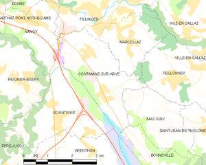
Arenthon (Arenthon)

- коммуна во Франции
 Hiking in Arenthon
Arenthon, located in the Haute-Savoie region of France, offers beautiful hiking opportunities amidst stunning alpine scenery. The area is characterized by lush green valleys, picturesque lakes, and views of the surrounding mountains, including the Mont Blanc range.
When hiking in Arenthon, you might enjoy trails that vary in difficulty, catering to both beginners and experienced hikers. Here are some key points to consider:
Hiking Trails
-
Local Trails: Look for marked trails that often connect to the larger network of paths in the region. The trails can lead to scenic viewpoints, forests, and meadows.
-
Parc Naturel Régional des Bauges: Not far from Arenthon, this regional park features various hiking routes that allow you to explore a wide range of flora and fauna.
-
Lakes and Rivers: Trails around local lakes, such as Lake Annecy or Lake Geneva, offer stunning views and a chance to rest by the water.
Preparation
- Level of Difficulty: Check trail markers and maps for difficulty levels and estimated times.
- Gear: Wear sturdy hiking boots and weather-appropriate clothing. A walking stick can also be helpful on uneven terrain.
- Water and Snacks: Always carry enough water and some snacks, especially if you’re planning a longer hike.
Best Time to Hike
- Spring and Summer: The best time for hiking is generally from late spring to early autumn when the weather is more stable, and the trails are clear of snow.
- Fall: Autumn can provide beautiful foliage and is a quieter season for hiking.
Safety
- Be mindful of changing weather conditions, especially in the mountains. Always check the forecast before you head out.
- Inform someone of your hiking plan, especially if venturing into less-populated areas.
Local Tips
- Engage with local hiking clubs or guides if you're unfamiliar with the area. They can provide valuable insights and ensure a safe hiking experience.
- Respect nature and follow the Leave No Trace principles to preserve the beauty of the environment.
Hiking in Arenthon can be a fantastic experience, offering both tranquility and adventure. Enjoy your time exploring this beautiful region!
- Страна:

- Почтовый код: 74800
- Координаты: 46° 6' 21" N, 6° 19' 58" E


- GPS треки (wikiloc): [Ссылка]
- Площадь: 11.47 кв.км
- Население: 1606
- Википедия английская: wiki(en)
- Википедия национальная: wiki(fr)
- Хранилище Wikidata: Wikidata: Q639603
- Катеория в википедии: [Ссылка]
- код Freebase: [/m/03ntxmy]
- код GeoNames: Альт: [6451011]
- номер SIREN: [217400183]
- код BNF: [152742783]
- код VIAF: Альт: [127608656]
- код ISNI: Альт: [0000 0001 1010 2412]
- код муниципалитета INSEE: 74018
Граничит с регионами:


Amancy
- коммуна во Франции
Hiking in Amancy
Amancy, located in the Haute-Savoie region of France, is a lesser-known but beautiful destination for hiking enthusiasts. Nestled near the stunning landscapes of the French Alps, it offers a variety of trails that cater to hikers of different skill levels....
- Страна:
- Почтовый код: 74800
- Координаты: 46° 4' 27" N, 6° 19' 45" E
- GPS треки (wikiloc): [Ссылка]
- Площадь: 8.62 кв.км
- Население: 2492
- Веб сайт: [Ссылка]


Бонвиль
- коммуна во Франции
Hiking in Бонвиль
Bonneville, located in the Haute-Savoie region of the French Alps, is a fantastic destination for hiking enthusiasts. The area is characterized by its stunning mountain scenery, lush valleys, and rich biodiversity. Here are some key details about hiking in and around Bonneville:...
- Страна:
- Почтовый код: 74130
- Координаты: 46° 4' 44" N, 6° 24' 3" E
- GPS треки (wikiloc): [Ссылка]
- Площадь: 27.15 кв.км
- Население: 12619
- Веб сайт: [Ссылка]


Saint-Pierre-en-Faucigny
- коммуна во Франции
Hiking in Saint-Pierre-en-Faucigny
Saint-Pierre-en-Faucigny is a picturesque commune located in the Haute-Savoie region of France, nestled in the foothills of the French Alps. The area is known for its stunning natural beauty, making it an excellent destination for hiking enthusiasts....
- Страна:
- Почтовый код: 74800
- Координаты: 46° 3' 35" N, 6° 22' 21" E
- GPS треки (wikiloc): [Ссылка]
- Площадь: 14.91 кв.км
- Население: 6241
- Веб сайт: [Ссылка]


Cornier
- коммуна во Франции
Hiking in Cornier
It seems there might be a small typo in your request, as there isn't a well-known hiking region called "Cornier." However, if you meant "Cornwall," I can provide information about hiking in that area. If there's a different location you were referring to, please let me know!...
- Страна:
- Почтовый код: 74800
- Координаты: 46° 5' 34" N, 6° 17' 59" E
- GPS треки (wikiloc): [Ссылка]
- Площадь: 6.78 кв.км
- Население: 1276
- Веб сайт: [Ссылка]

Contamine-sur-Arve
- коммуна во Франции
Hiking in Contamine-sur-Arve
Contamine-sur-Arve is a charming commune located in the Haute-Savoie region of France, near Mont Blanc. It offers a variety of hiking opportunities that cater to different skill levels and preferences. Here are some highlights and tips for hiking in and around Contamine-sur-Arve:...
- Страна:
- Почтовый код: 74130
- Координаты: 46° 7' 42" N, 6° 20' 26" E
- GPS треки (wikiloc): [Ссылка]
- Площадь: 6.92 кв.км
- Население: 1940
- Веб сайт: [Ссылка]


Scientrier
- коммуна во Франции
Hiking in Scientrier
Scientrier is a commune located in the Haute-Savoie department in the Auvergne-Rhône-Alpes region of southeastern France, near Lake Geneva. While it may not be as widely known as other hiking destinations in the region, it offers a variety of outdoor activities and trails that can appeal to hikers of all levels....
- Страна:
- Почтовый код: 74930
- Координаты: 46° 7' 8" N, 6° 18' 56" E
- GPS треки (wikiloc): [Ссылка]
- Площадь: 7.21 кв.км
- Население: 1156