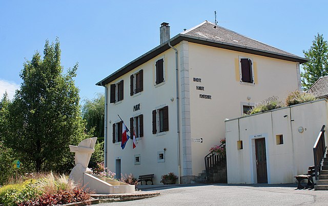
Sillingy (Sillingy)

- коммуна во Франции
 Hiking in Sillingy
Sillingy, located in the Haute-Savoie region of France, offers a variety of hiking opportunities for outdoor enthusiasts. Nestled near the picturesque Annecy and surrounded by the stunning Alps, Sillingy provides breathtaking views and a range of trails suitable for different skill levels.
Key Highlights of Hiking in Sillingy:
-
Scenic Trails:
- The region features a mix of wooded areas, hilly terrain, and meadows, allowing for picturesque walks and hikes that reveal beautiful landscapes, especially in spring and summer when the flora is in full bloom.
-
Nearby Natural Attractions:
- Sillingy is in proximity to the Semnoz and Parmelan mountains, both offering a range of hiking paths that can cater to novice hikers and more experienced adventurers. These routes often provide stunning panoramas of Lake Annecy and the surrounding Alps.
-
Wildlife Watching:
- While hiking in the area, you may encounter various wildlife species, including deer, birds, and possibly even chamois in the higher elevations.
-
Cultural Exploration:
- Along some trails, you can discover local culture and heritage, including old farms and traditional Alpine architecture, which adds an enriching aspect to your hiking experience.
-
Seasons:
- Spring and summer are ideal for hiking, with trails accessible and blooming wildflowers. Autumn offers stunning fall foliage. Winter hiking is also possible, but be prepared for snow and colder conditions if you venture into higher elevations.
Tips for Hiking in Sillingy:
- Trail Selection: Always choose trails that match your skill level. There are various marked paths, and local maps can be obtained to help navigate.
- Weather Awareness: The weather can change quickly in the mountains; check the forecast before heading out and be prepared for sudden changes.
- Sufficient Gear: Wear sturdy hiking boots, dress in layers, and bring essentials such as water, snacks, and a first-aid kit.
- Respect Nature: Stick to marked trails to minimize your impact on the environment, and always follow local guidelines for wildlife and natural habitat preservation.
Whether you’re looking for a leisurely walk or a more challenging hike, Sillingy and its surrounding area provide a beautiful backdrop for outdoor adventure. Enjoy your hiking experience!
- Страна:

- Почтовый код: 74330
- Координаты: 45° 56' 45" N, 6° 2' 7" E


- GPS треки (wikiloc): [Ссылка]
- Площадь: 14.84 кв.км
- Население: 5045
- Веб сайт: http://www.sillingy74.fr
- Википедия английская: wiki(en)
- Википедия национальная: wiki(fr)
- Хранилище Wikidata: Wikidata: Q845844
- Катеория в википедии: [Ссылка]
- код Freebase: [/m/03ntzmw]
- код GeoNames: Альт: [6454673]
- номер SIREN: [217402726]
- код BNF: [15274526p]
- код Pleiades: [167924]
- код муниципалитета INSEE: 74272
Граничит с регионами:

Vaulx
Hiking in Vaulx
Vaulx is a charming village located in the Haute-Savoie region of the French Alps, known for its stunning natural landscapes and proximity to the majestic mountains. Hiking in this area can be a delightful experience for both beginners and seasoned hikers....
- Страна:
- Почтовый код: 74150
- Координаты: 45° 55' 48" N, 5° 59' 44" E
- GPS треки (wikiloc): [Ссылка]
- Площадь: 11.19 кв.км
- Население: 952
- Веб сайт: [Ссылка]


Nonglard
- коммуна во Франции
Hiking in Nonglard
Nonglard is not widely recognized in popular hiking destinations, so it may refer to a less-known area or community. However, if you are looking for hiking opportunities in a specific region such as a national park, forest reserve, or mountainous area in or near Nonglard, please provide more details....
- Страна:
- Почтовый код: 74330
- Координаты: 45° 55' 5" N, 6° 1' 10" E
- GPS треки (wikiloc): [Ссылка]
- Площадь: 4.12 кв.км
- Население: 608
- Веб сайт: [Ссылка]
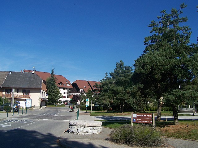

Poisy
- коммуна во Франции
Hiking in Poisy
Poisy, located near Annecy in the Auvergne-Rhône-Alpes region of France, offers beautiful hiking opportunities with stunning views of the surrounding mountains and Lake Annecy. Here are some things to consider if you’re planning to hike in and around Poisy:...
- Страна:
- Почтовый код: 74330
- Координаты: 45° 55' 20" N, 6° 3' 47" E
- GPS треки (wikiloc): [Ссылка]
- Площадь: 11.33 кв.км
- Население: 7594
- Веб сайт: [Ссылка]


Chilly
- коммуна во Франции
Hiking in Chilly
Chilly is a charming commune in the Haute-Savoie region of France, located near the beautiful French Alps. This area offers a variety of hiking opportunities for both casual walkers and more experienced trekkers. Here are some highlights about hiking in and around Chilly:...
- Страна:
- Почтовый код: 74270
- Координаты: 45° 59' 30" N, 5° 57' 10" E
- GPS треки (wikiloc): [Ссылка]
- Площадь: 18.58 кв.км
- Население: 1281

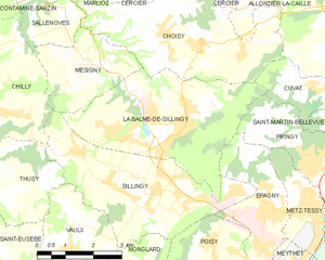
La Balme-de-Sillingy
- коммуна во Франции
Hiking in La Balme-de-Sillingy
La Balme-de-Sillingy, located in the Haute-Savoie region of France, offers some lovely hiking opportunities amidst beautiful Alpine scenery. The area is characterized by rolling hills, lush forests, and stunning views of the surrounding mountains, making it a delightful spot for both casual walkers and more experienced hikers....
- Страна:
- Почтовый код: 74330
- Координаты: 45° 57' 40" N, 6° 2' 31" E
- GPS треки (wikiloc): [Ссылка]
- Площадь: 16.51 кв.км
- Население: 5027

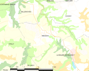
Mésigny
- коммуна во Франции
Hiking in Mésigny
Mésigny, a charming village located in the Auvergne-Rhône-Alpes region of France, offers a variety of hiking opportunities that showcase the region's natural beauty. While the village itself is small, the surrounding area features beautiful landscapes, rolling hills, and scenic views that are perfect for outdoor enthusiasts....
- Страна:
- Почтовый код: 74330
- Координаты: 45° 59' 8" N, 6° 0' 10" E
- GPS треки (wikiloc): [Ссылка]
- Площадь: 6.73 кв.км
- Население: 689
- Веб сайт: [Ссылка]


Thusy
- коммуна во Франции
Hiking in Thusy
Thusy is a picturesque village located in the Haute-Savoie region of the French Alps. It serves as an excellent base for hikers seeking both stunning landscapes and a variety of trails. Here are some highlights and information about hiking in the Thusy area:...
- Страна:
- Почтовый код: 74150
- Координаты: 45° 56' 51" N, 5° 56' 56" E
- GPS треки (wikiloc): [Ссылка]
- Площадь: 10.74 кв.км
- Население: 1076
- Веб сайт: [Ссылка]