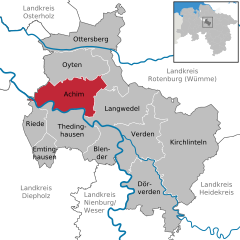
Achim (Achim)
- municipality in the district of Verden, in Lower Saxony, Germany
Achim, a town located in Lower Saxony, Germany, is surrounded by picturesque landscapes that provide excellent hiking opportunities. While the town itself may not be widely recognized for extensive hiking trails, there are several nearby areas and natural features that enthusiasts can explore.
Hiking Locations Near Achim:
-
Weser River Trails: The Weser River runs near Achim and offers scenic riverside walks. You can follow the river through charming landscapes, wetlands, and farmland, providing a serene hiking experience.
-
Nature Reserves: The surrounding regions may have protected natural areas, where trails are often marked for hiking. Look for nature reserves nearby that provide opportunities to observe local flora and fauna.
-
Lüneburg Heath (Lüneburger Heide): A bit further from Achim, this famous heathland offers extensive hiking trails through heather and moorland. The beautiful landscapes, especially in late summer when the heather blooms, make it a popular destination for hikers.
-
Bremer Ried: This nature reserve can be explored via various walking paths, allowing hikers to experience diverse ecosystems, including wetlands and woodlands.
-
Regional Hiking Trails: The area around Achim is often traversed by regional hiking routes that connect towns and villages. Check local maps for well-marked trails suitable for day hikes.
Tips for Hiking in Achim and Surroundings:
-
Weather Preparedness: Check weather forecasts before heading out, as conditions can change quickly. Dress in layers and bring rain gear if necessary.
-
Local Maps: Use local hiking maps or apps to ensure you're on designated trails and to find points of interest along the route.
-
Safety: Inform someone of your hiking plans and estimated return time. Always carry a first aid kit and plenty of water.
-
Respect Nature: Stay on marked trails to help preserve the natural environment, and adhere to local regulations regarding wildlife and plant protection.
Whether you are looking for a leisurely stroll or a more challenging hike, the area around Achim can offer a nice escape into nature. Enjoy your hiking!
- Country:

- Postal Code: 28832
- Local Dialing Code: 04202
- Licence Plate Code: VER
- Coordinates: 53° 0' 51" N, 9° 1' 35" E


- GPS tracks (wikiloc): [Link]
- AboveSeaLevel: 14 м m
- Area: 68.06 sq km
- Population: 31890
- Web site: http://www.achim.de/
- Wikipedia en: wiki(en)
- Wikipedia: wiki(de)
- Wikidata storage: Wikidata: Q16143
- Wikipedia Commons Category: [Link]
- Freebase ID: [/m/0cl8fv]
- Freebase ID: [/m/0cl8fv]
- Freebase ID: [/m/0cl8fv]
- GeoNames ID: Alt: [2959681]
- GeoNames ID: Alt: [2959681]
- GeoNames ID: Alt: [2959681]
- VIAF ID: Alt: [140149599]
- VIAF ID: Alt: [140149599]
- VIAF ID: Alt: [140149599]
- OSM relation ID: [1182036]
- OSM relation ID: [1182036]
- OSM relation ID: [1182036]
- GND ID: Alt: [4000368-1]
- GND ID: Alt: [4000368-1]
- GND ID: Alt: [4000368-1]
- MusicBrainz area ID: [971bbb90-ed80-44f9-a87f-cab4f9fdf012]
- MusicBrainz area ID: [971bbb90-ed80-44f9-a87f-cab4f9fdf012]
- MusicBrainz area ID: [971bbb90-ed80-44f9-a87f-cab4f9fdf012]
- German municipality key: 03361001
- German municipality key: 03361001
- German municipality key: 03361001
Includes regions:
Embsen (Achim)
- human settlement in Germany
Embsem, located near Achim in Lower Saxony, Germany, is a quaint area that offers several hiking opportunities, especially for those who appreciate nature and want to experience the serene landscapes of the region....
- Country:

- Postal Code: 28832
- Local Dialing Code: 04202
- Coordinates: 53° 1' 57" N, 9° 1' 43" E


- GPS tracks (wikiloc): [Link]
Uphusen
- human settlement in Germany
Uphusen is a small village located in the municipality of Achim, in Lower Saxony, Germany. While not as well-known as larger hiking destinations, there are opportunities for hiking and enjoying the natural beauty of the area....
- Country:

- Coordinates: 53° 1' 46" N, 8° 58' 15" E


- GPS tracks (wikiloc): [Link]

Uesen
- human settlement in Germany
Uesen is a small town located in the North German state of Lower Saxony. While it may not be as widely recognized for hiking as more mountainous regions, there are several opportunities to explore the natural beauty surrounding the area....
- Country:

- Postal Code: 28832
- Local Dialing Code: 04202
- Coordinates: 53° 0' 6" N, 9° 3' 0" E


- GPS tracks (wikiloc): [Link]
Badenermoor
- human settlement in Germany
Badenermoor is a beautiful area in Germany known for its stunning natural landscapes and diverse ecosystems. It is located near Baden-Baden, in the Black Forest region of Baden-Württemberg. Here are some insights into hiking in Badenermoor:...
- Country:

- Coordinates: 53° 1' 54" N, 9° 6' 52" E


- GPS tracks (wikiloc): [Link]
Bierden
- human settlement
Bierden is a quaint village located in the Netherlands, specifically in the municipality of Kruideniers, in the province of Drenthe. While Bierden itself may not be widely known for hiking, the surrounding areas offer some opportunities for outdoor activities, including walking and exploring nature....
- Country:

- Postal Code: 28832
- Local Dialing Code: 04202
- Coordinates: 53° 0' 49" N, 9° 0' 22" E


- GPS tracks (wikiloc): [Link]
Bollen
- human settlement in Germany
Bollen, a district in Achim, Germany, offers beautiful nature and various outdoor opportunities for hiking enthusiasts. The area features a mix of landscapes, including woodlands, meadows, and rivers, making it an ideal location for those looking to explore nature....
- Country:

- Postal Code: 28832
- Local Dialing Code: 04202
- Coordinates: 53° 0' 34" N, 8° 56' 41" E


- GPS tracks (wikiloc): [Link]
- AboveSeaLevel: 7 м m
Borstel
- human settlement in Germany
Borstel, a small village near Achim in Lower Saxony, Germany, is surrounded by beautiful rural landscapes that can be great for hiking. While the area may not be as famous for its hiking trails as some other regions in Germany, it offers a peaceful environment and various paths for exploration. Here are some highlights of hiking in and around Borstel:...
- Country:

- Coordinates: 53° 1' 30" N, 9° 3' 51" E


- GPS tracks (wikiloc): [Link]

