Verden (Landkreis Verden)

- district in Lower Saxony, Germany
 Hiking in Verden
Verden, located in Lower Saxony, Germany, is an area that offers various outdoor activities, including hiking. The district is characterized by its lush landscapes, woodlands, and scenic countryside, making it a pleasant spot for nature lovers and hikers alike.
Popular Hiking Areas:
-
Verdener City Forest (Verdener Stadtwald): This expansive woodland is ideal for hikers seeking a mix of shaded paths and open areas. The trails are often well-marked and cater to different skill levels.
-
Niederes Land: This flat landscape features several trails that provide beautiful views of the open fields and meadows. It's a fantastic area for leisurely hikes and birdwatching.
-
Wümme River Trails: The Wümme River offers a unique experience with trails alongside the water, allowing hikers to enjoy serene riverside vistas and diverse wildlife.
Tips for Hiking in Verden:
- Trail Maps: It's advisable to have a good trail map or a hiking app for navigation. Many of the trails are well-marked, but it's always good to be prepared.
- Local Guides: Consider joining a guided hike to learn more about the local flora and fauna.
- Weather: Check the weather before heading out, as conditions can change rapidly. Dress in layers to adapt to varying temperatures.
- Equipment: Wear appropriate hiking shoes and consider bringing trekking poles, especially if you're exploring more uneven terrain.
- Respect Nature: Follow the Leave No Trace principles by staying on marked paths and carrying out any trash.
Nearby Attractions:
- Verden Cathedral: If you're interested in a bit of culture after your hike, the historic cathedral is worth a visit.
- Horse Riding: Verden is known for its equestrian culture, so there may be opportunities to combine hiking with horseback riding in certain areas.
Overall, Verden offers a peaceful and natural setting for hiking enthusiasts. Whether you're looking for a short stroll or a longer trek, you will find paths that suit your needs.
- Country:

- Licence Plate Code: VER
- Coordinates: 53° 0' 0" N, 9° 10' 12" E


- GPS tracks (wikiloc): [Link]
- AboveSeaLevel: 23 м m
- Area: 787.70 sq km
- Population: 135842
- Web site: http://www.landkreis-verden.de/
- Wikipedia en: wiki(en)
- Wikipedia: wiki(de)
- Wikidata storage: Wikidata: Q5927
- Wikipedia Commons Category: [Link]
- Wikipedia Commons Maps Category: [Link]
- Freebase ID: [/m/0138ss]
- Freebase ID: [/m/0138ss]
- Freebase ID: [/m/0138ss]
- GeoNames ID: Alt: [2817598]
- GeoNames ID: Alt: [2817598]
- GeoNames ID: Alt: [2817598]
- VIAF ID: Alt: [146603915]
- VIAF ID: Alt: [146603915]
- VIAF ID: Alt: [146603915]
- OSM relation ID: [62740]
- OSM relation ID: [62740]
- OSM relation ID: [62740]
- GND ID: Alt: [4062685-4]
- GND ID: Alt: [4062685-4]
- GND ID: Alt: [4062685-4]
- archINFORM location ID: [11039]
- archINFORM location ID: [11039]
- archINFORM location ID: [11039]
- Library of Congress authority ID: Alt: [n82094609]
- Library of Congress authority ID: Alt: [n82094609]
- Library of Congress authority ID: Alt: [n82094609]
- TGN ID: [7090033]
- TGN ID: [7090033]
- TGN ID: [7090033]
- NUTS code: [DE93B]
- NUTS code: [DE93B]
- NUTS code: [DE93B]
- German district key: 03361
- German district key: 03361
- German district key: 03361
Includes regions:

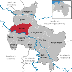
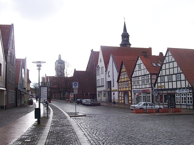
Achim
- municipality in the district of Verden, in Lower Saxony, Germany
Hiking in Achim
Achim, a town located in Lower Saxony, Germany, is surrounded by picturesque landscapes that provide excellent hiking opportunities. While the town itself may not be widely recognized for extensive hiking trails, there are several nearby areas and natural features that enthusiasts can explore....
- Country:
- Postal Code: 28832
- Local Dialing Code: 04202
- Licence Plate Code: VER
- Coordinates: 53° 0' 51" N, 9° 1' 35" E
- GPS tracks (wikiloc): [Link]
- AboveSeaLevel: 14 м m
- Area: 68.06 sq km
- Population: 31890
- Web site: [Link]

Verden (Aller)
- municipality in Lower Saxony, Germany
Hiking in Verden (Aller)
Verden an der Aller is a charming town in Lower Saxony, Germany, known for its beautiful landscapes and historical significance. While it may not be as widely recognized for hiking as some other areas in Germany, it offers a variety of trails and natural settings that can provide a great outdoor experience for hikers of different skill levels....
- Country:
- Postal Code: 27283
- Local Dialing Code: 04231; 04230
- Licence Plate Code: VER
- Coordinates: 52° 55' 16" N, 9° 13' 50" E
- GPS tracks (wikiloc): [Link]
- AboveSeaLevel: 20 м m
- Area: 71.58 sq km
- Population: 27539
- Web site: [Link]

Thedinghausen
- Samtgemeinde in Lower Saxony
Hiking in Thedinghausen
Thedinghausen is a picturesque region located in Lower Saxony, Germany, and offers a variety of hiking opportunities that cater to different skill levels. While it may not be as widely known as some of Germany's larger national parks or hiking areas, it does have its charm with scenic landscapes, historical sites, and peaceful trails....
- Country:
- Coordinates: 52° 58' 12" N, 9° 1' 12" E
- GPS tracks (wikiloc): [Link]
- Area: 152.3 sq km
- Population: 15068
- Web site: [Link]

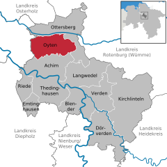
Oyten
- municipality of Germany
Hiking in Oyten
Oyten is a small town located in Lower Saxony, Germany, near the city of Bremen. While it might not be as famous for its hiking trails as some larger regions, there are still opportunities for outdoor activities and enjoying nature in and around Oyten....
- Country:
- Postal Code: 28876
- Local Dialing Code: 04207
- Licence Plate Code: VER
- Coordinates: 53° 3' 40" N, 9° 1' 4" E
- GPS tracks (wikiloc): [Link]
- AboveSeaLevel: 15 м m
- Area: 63.47 sq km
- Population: 15649
- Web site: [Link]


Kirchlinteln
- municipality of Germany
Hiking in Kirchlinteln
Kirchlinteln is a charming village located in Lower Saxony, Germany. The area offers a variety of hiking opportunities, primarily characterized by its picturesque landscapes, serene countryside, and lush forests....
- Country:
- Postal Code: 27308
- Local Dialing Code: 04238; 04237; 04236; 04231; 04230
- Licence Plate Code: VER
- Coordinates: 52° 57' 0" N, 9° 19' 0" E
- GPS tracks (wikiloc): [Link]
- AboveSeaLevel: 51 м m
- Area: 174.13 sq km
- Population: 9990
- Web site: [Link]


Dörverden
- municipality of Germany
Hiking in Dörverden
Dörverden is a delightful area for hiking enthusiasts, located in Lower Saxony, Germany. It offers a scenic mix of lush forests, winding rivers, and picturesque landscapes. Here are some highlights and tips for hiking in Dörverden:...
- Country:
- Postal Code: 27313
- Local Dialing Code: 04234
- Licence Plate Code: VER
- Coordinates: 52° 51' 0" N, 9° 14' 0" E
- GPS tracks (wikiloc): [Link]
- AboveSeaLevel: 16 м m
- Area: 83.32 sq km
- Population: 9070
- Web site: [Link]


Langwedel
- municipality of Germany
Hiking in Langwedel
Langwedel is a quaint municipality located in Lower Saxony, Germany, and while it may not be as famous for hiking as larger national parks or mountainous regions, it still offers some lovely outdoor experiences. Here are some points to consider if you're planning to hike in and around Langwedel:...
- Country:
- Postal Code: 27299
- Local Dialing Code: 04297; 04235; 04232
- Licence Plate Code: VER
- Coordinates: 52° 58' 0" N, 9° 13' 0" E
- GPS tracks (wikiloc): [Link]
- AboveSeaLevel: 22 м m
- Area: 76.11 sq km
- Population: 14415
- Web site: [Link]


Ottersberg
- municipality of Germany
Hiking in Ottersberg
Ottersberg is a charming village located in Lower Saxony, Germany, and while it may not be as widely known for hiking as some larger destinations, there are still great opportunities for outdoor enthusiasts in the area....
- Country:
- Postal Code: 28870
- Local Dialing Code: 04297; 04293; 04205
- Licence Plate Code: VER
- Coordinates: 53° 6' 0" N, 9° 9' 0" E
- GPS tracks (wikiloc): [Link]
- AboveSeaLevel: 14 м m
- Area: 99.03 sq km
- Population: 12818
- Web site: [Link]
Shares border with regions:

Bremen
- city in the Bremen federated state, Germany
Hiking in Bremen
Bremen, while primarily known for its rich history and vibrant cultural scene, doesn't have the extensive hiking trails commonly found in more mountainous regions of Germany. However, there are some lovely outdoor areas and walking opportunities nearby that can satisfy those looking for a hiking experience....
- Country:
- Postal Code: 28779; 28777; 28759; 28757; 28755; 28719; 28717; 28359; 28357; 28355; 28329; 28327; 28325; 28309; 28307; 28279; 28277; 28259; 28239; 28237; 28219; 28217; 28215; 28213; 28211; 28209; 28207; 28205; 28203; 28201; 28199; 28197; 28195
- Local Dialing Code: 0421
- Licence Plate Code: HB
- Coordinates: 53° 4' 37" N, 8° 48' 32" E
- GPS tracks (wikiloc): [Link]
- AboveSeaLevel: 6 м m
- Area: 326.18 sq km
- Population: 568006
- Web site: [Link]


Heidekreis
- district in Lower Saxony, Germany
Hiking in Heidekreis
Heidekreis, located in Lower Saxony, Germany, offers a variety of hiking opportunities amidst beautiful natural landscapes. The region is characterized by its mix of heathlands, forests, and moorlands, making it an attractive destination for outdoor enthusiasts....
- Country:
- Capital: Bad Fallingbostel
- Licence Plate Code: HK
- Coordinates: 52° 55' 12" N, 9° 45' 0" E
- GPS tracks (wikiloc): [Link]
- AboveSeaLevel: 64 м m
- Area: 1873.50 sq km
- Population: 139641
- Web site: [Link]


Rotenburg (Wümme)
- German district in Lower Saxony
Hiking in Rotenburg (Wümme)
Rotenburg (district), located in Lower Saxony, Germany, offers various hiking opportunities, particularly for those interested in exploring scenic landscapes and natural beauty. Here are some highlights and suggestions for hiking in this region:...
- Country:
- Licence Plate Code: ROW; BRV
- Coordinates: 53° 15' 0" N, 9° 19' 48" E
- GPS tracks (wikiloc): [Link]
- AboveSeaLevel: 28 м m
- Population: 163372
- Web site: [Link]


Osterholz
- district in Lower Saxony, Germany
Hiking in Osterholz
Osterholz, located in Lower Saxony, Germany, offers a variety of hiking opportunities for outdoor enthusiasts. The region is characterized by its beautiful landscapes, including forests, heathlands, and rivers, providing a picturesque setting for hikers. Here are some highlights and tips for hiking in Osterholz:...
- Country:
- Capital: Osterholz-Scharmbeck
- Licence Plate Code: OHZ
- Coordinates: 53° 15' 0" N, 8° 49' 48" E
- GPS tracks (wikiloc): [Link]
- AboveSeaLevel: 3 м m
- Area: 650.73 sq km
- Population: 112695
- Web site: [Link]


Diepholz
- district in Lower Saxony, Germany
Hiking in Diepholz
Diepholz is a district located in Lower Saxony, Germany, known for its scenic landscapes and outdoor recreational opportunities, including hiking. Here are some insights about hiking in and around Diepholz:...
- Country:
- Licence Plate Code: SY; DH
- Coordinates: 52° 40' 12" N, 8° 34' 48" E
- GPS tracks (wikiloc): [Link]
- AboveSeaLevel: 52 м m
- Area: 1987.00 sq km
- Population: 209671
- Web site: [Link]


Nienburg/Weser
- district in Lower Saxony, Germany
Hiking in Nienburg/Weser
Nienburg (district) in Lower Saxony, Germany, offers a range of outdoor activities, including hiking, which can be enjoyed in its scenic landscapes. While the region isn't known for high mountains, it features beautiful rolling hills, tranquil rivers, and charming villages, making it an excellent area for hiking enthusiasts who appreciate more gentle terrains and lush nature....
- Country:
- Licence Plate Code: NI
- Coordinates: 52° 40' 12" N, 9° 10' 12" E
- GPS tracks (wikiloc): [Link]
- AboveSeaLevel: 21 м m
- Area: 1399.00 sq km
- Population: 121503
- Web site: [Link]