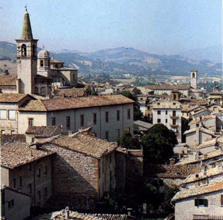
Acqualagna (Acqualagna)
.svg)
- Italian comune
 Hiking in Acqualagna
Acqualagna, located in the Marche region of Italy, is a charming destination known for its stunning natural landscapes and rich truffle heritage. Hiking around Acqualagna offers a unique blend of beautiful scenery, cultural experiences, and opportunities to connect with nature.
Trails and Routes
-
Sentiero del Truffle: This trail celebrates the area's truffle-producing heritage. It combines beautiful forested areas and charming rural landscapes, often leading to spots where you might learn about local truffle hunting traditions.
-
Monte Nerone: A prominent mountain near Acqualagna, Monte Nerone has several trails that range in difficulty. The views from the summit are breathtaking, offering panoramas of the surrounding Apennines and valleys. It’s an excellent place for both experienced hikers and those looking for a moderate challenge.
-
Gola del Furlo: A nearby gorge offering spectacular views and various trails. The area is rich in flora and fauna and provides opportunities for birdwatching and photography.
Nature and Wildlife
The region around Acqualagna is diverse, featuring lush forests, wildlife, and rivers. Hikers can expect to encounter a variety of flora and fauna, especially in protected areas like the Furlo Nature Reserve.
Best Times to Hike
The ideal time for hiking in this region is during the spring (April to June) and early autumn (September to October) when temperatures are mild, and the trails are less crowded. Summer can be hot, and winter may bring snow to the higher elevations.
Hiking Tips
- Gear up: Always wear sturdy hiking boots and bring plenty of water and snacks.
- Local guides: Consider hiring a local guide or joining a guided hike to enrich your experience and learn more about the area’s ecology and history.
- Respect nature: Follow the Leave No Trace principles, and ensure you stay on marked trails to protect the local environment.
Cultural Experiences
Post-hike, make sure to explore Acqualagna’s local cuisine, especially its truffles, which can often be sampled in local trattorias. Participating in a truffle hunting experience can also be a memorable and unique addition to your visit.
Acqualagna offers a harmonious blend of outdoor adventures and cultural experiences that cater to both hiking enthusiasts and casual walkers alike. Enjoy your hike and the natural beauty of this hidden gem in Italy!
- Country:

- Postal Code: 61041
- Local Dialing Code: 0721
- Licence Plate Code: PU
- Coordinates: 43° 37' 0" N, 12° 40' 16" E


- GPS tracks (wikiloc): [Link]
- AboveSeaLevel: 204 м m
- Area: 50.69 sq km
- Population: 4412
- Web site: http://www.comune.acqualagna.ps.it
- Wikipedia en: wiki(en)
- Wikipedia: wiki(it)
- Wikidata storage: Wikidata: Q190164
- Wikipedia Commons Category: [Link]
- Freebase ID: [/m/0gl3w8]
- GeoNames ID: Alt: [6541048]
- VIAF ID: Alt: [234784565]
- OSM relation ID: [42539]
- GND ID: Alt: [4639374-2]
- TGN ID: [7003984]
- UN/LOCODE: [ITAC5]
- Digital Atlas of the Roman Empire ID: [42570]
- ISTAT ID: 041001
- Italian cadastre code: A035
Shares border with regions:


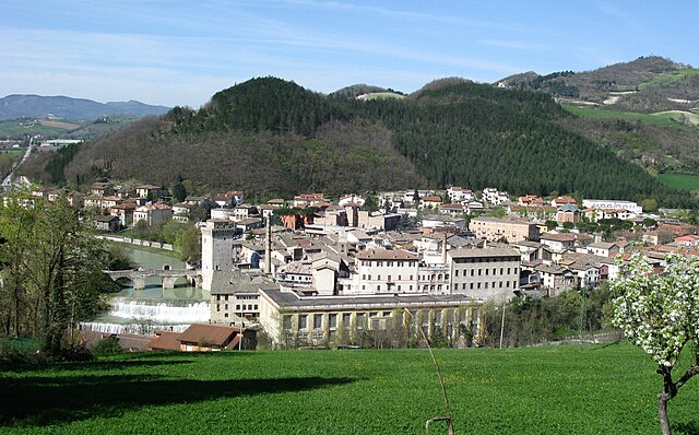
Urbania
- Italian comune
Hiking in Urbania
Urbania, a small town located in the Marche region of Italy, is rich in historical charm and surrounded by picturesque landscapes. While it may not be as renowned for hiking as some larger natural parks or mountainous regions, there are still opportunities to explore the outdoors and enjoy the beauty of the surrounding countryside. Here are some aspects to consider when hiking in and around Urbania:...
- Country:
- Postal Code: 61049
- Local Dialing Code: 0722
- Licence Plate Code: PU
- Coordinates: 43° 40' 4" N, 12° 31' 20" E
- GPS tracks (wikiloc): [Link]
- AboveSeaLevel: 273 м m
- Area: 77.53 sq km
- Population: 7076
- Web site: [Link]

Cagli
- Italian comune
Hiking in Cagli
Cagli, a charming town in the Marche region of Italy, is surrounded by beautiful natural landscapes, making it a great destination for hiking enthusiasts. The area is characterized by rolling hills, lush forests, and scenic views that are perfect for both novice and experienced hikers....
- Country:
- Postal Code: 61043
- Local Dialing Code: 0721
- Licence Plate Code: PU
- Coordinates: 43° 32' 49" N, 12° 38' 50" E
- GPS tracks (wikiloc): [Link]
- AboveSeaLevel: 276 м m
- Area: 226.46 sq km
- Population: 8546
- Web site: [Link]

Fermignano
- comune of Italy
Hiking in Fermignano
Fermignano, located in the Marche region of Italy, offers a serene landscape for hiking enthusiasts. Surrounded by picturesque hills and lush countryside, it serves as a wonderful base for exploring the area’s natural beauty....
- Country:
- Postal Code: 61033
- Local Dialing Code: 0722
- Licence Plate Code: PU
- Coordinates: 43° 40' 36" N, 12° 38' 42" E
- GPS tracks (wikiloc): [Link]
- AboveSeaLevel: 200 м m
- Area: 43.72 sq km
- Population: 8482
- Web site: [Link]


Piobbico
- Italian comune
Hiking in Piobbico
Piobbico, a charming town in the Marche region of Italy, is nestled in the beautiful landscape of the Apennine Mountains. Known for its stunning natural beauty, Piobbico offers a variety of hiking opportunities for outdoor enthusiasts. Here are some highlights for hiking in and around Piobbico:...
- Country:
- Postal Code: 61046
- Local Dialing Code: 0722
- Licence Plate Code: PU
- Coordinates: 43° 35' 17" N, 12° 30' 35" E
- GPS tracks (wikiloc): [Link]
- AboveSeaLevel: 339 м m
- Area: 48.2 sq km
- Population: 1997
- Web site: [Link]
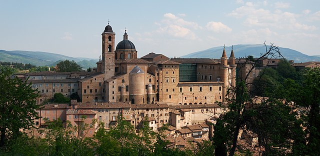

Urbino
- city in the Marche region of Italy
Hiking in Urbino
Urbino, a historic city in the Marche region of Italy, is surrounded by beautiful landscapes and offers various hiking opportunities for outdoor enthusiasts. Here are some key points about hiking in and around Urbino:...
- Country:
- Postal Code: 61029
- Local Dialing Code: 0722
- Licence Plate Code: PU
- Coordinates: 43° 43' 31" N, 12° 38' 14" E
- GPS tracks (wikiloc): [Link]
- AboveSeaLevel: 451 м m
- Area: 226.5 sq km
- Population: 14558
- Web site: [Link]