Fermignano (Fermignano)
.svg)
- comune of Italy
 Hiking in Fermignano
Fermignano, located in the Marche region of Italy, offers a serene landscape for hiking enthusiasts. Surrounded by picturesque hills and lush countryside, it serves as a wonderful base for exploring the area’s natural beauty.
Hiking Trails
-
Sentiero del Fiume Metauro: This trail follows the Metauro River and showcases beautiful pastoral landscapes. It’s great for both walking and biking, providing opportunities to enjoy the local flora and fauna.
-
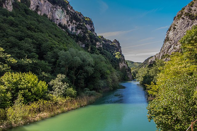
Gola del Furlo: A short drive from Fermignano, this striking gorge is perfect for more adventurous hikers. Trails here offer stunning views of the rock formations and the river below. The natural reserve is rich in biodiversity, making it a fascinating area to explore.
-
Monte Catria: If you're looking for more challenging hikes, Monte Catria is a bit further away but worth the trip. The summit provides panoramic views of the surrounding regions, and the trails vary in difficulty.
-
Local Trails: There are several lesser-known paths around Fermignano that lead to small villages, vineyards, and olive groves. These are great for those wanting a peaceful hike away from crowds.
Tips for Hiking in Fermignano
- Best Time to Hike: Spring (April to June) and early autumn (September to October) are ideal for hiking due to mild temperatures and beautiful scenery.
- Gear: Comfortable hiking shoes are essential, as some paths may be uneven or steep. It’s also advisable to bring water, snacks, and sun protection.
- Local Regulations: Always check local maps for trails and be aware of any regulations regarding wildlife and natural reserves.
- Cultural Sites: Take time to explore Fermignano itself, including its historical sites and local cuisine, to enhance your hiking experience.
Fermignano's blend of scenic trails and cultural charm makes it an excellent destination for both novice and experienced hikers looking to immerse themselves in the Italian countryside.
- Country:

- Postal Code: 61033
- Local Dialing Code: 0722
- Licence Plate Code: PU
- Coordinates: 43° 40' 36" N, 12° 38' 42" E


- GPS tracks (wikiloc): [Link]
- AboveSeaLevel: 200 м m
- Area: 43.72 sq km
- Population: 8482
- Web site: http://www.comune.fermignano.pu.it/
- Wikipedia en: wiki(en)
- Wikipedia: wiki(it)
- Wikidata storage: Wikidata: Q190623
- Wikipedia Commons Category: [Link]
- Freebase ID: [/m/0gl44m]
- GeoNames ID: Alt: [6541839]
- VIAF ID: Alt: [149815788]
- OSM relation ID: [42553]
- archINFORM location ID: [14046]
- WOEID: [715392]
- TGN ID: [7008554]
- UN/LOCODE: [ITFMN]
- ISTAT ID: 041014
- Italian cadastre code: D541
Shares border with regions:


Urbania
- Italian comune
Hiking in Urbania
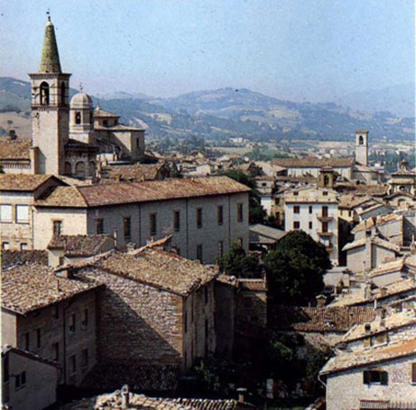
Urbania, a small town located in the Marche region of Italy, is rich in historical charm and surrounded by picturesque landscapes. While it may not be as renowned for hiking as some larger natural parks or mountainous regions, there are still opportunities to explore the outdoors and enjoy the beauty of the surrounding countryside. Here are some aspects to consider when hiking in and around Urbania:...
- Country:
- Postal Code: 61049
- Local Dialing Code: 0722
- Licence Plate Code: PU
- Coordinates: 43° 40' 4" N, 12° 31' 20" E
- GPS tracks (wikiloc): [Link]
- AboveSeaLevel: 273 м m
- Area: 77.53 sq km
- Population: 7076
- Web site: [Link]

Acqualagna
- Italian comune
Hiking in Acqualagna
Acqualagna, located in the Marche region of Italy, is a charming destination known for its stunning natural landscapes and rich truffle heritage. Hiking around Acqualagna offers a unique blend of beautiful scenery, cultural experiences, and opportunities to connect with nature....
- Country:
- Postal Code: 61041
- Local Dialing Code: 0721
- Licence Plate Code: PU
- Coordinates: 43° 37' 0" N, 12° 40' 16" E
- GPS tracks (wikiloc): [Link]
- AboveSeaLevel: 204 м m
- Area: 50.69 sq km
- Population: 4412
- Web site: [Link]

Cagli
- Italian comune
Hiking in Cagli
Cagli, a charming town in the Marche region of Italy, is surrounded by beautiful natural landscapes, making it a great destination for hiking enthusiasts. The area is characterized by rolling hills, lush forests, and scenic views that are perfect for both novice and experienced hikers....
- Country:
- Postal Code: 61043
- Local Dialing Code: 0721
- Licence Plate Code: PU
- Coordinates: 43° 32' 49" N, 12° 38' 50" E
- GPS tracks (wikiloc): [Link]
- AboveSeaLevel: 276 м m
- Area: 226.46 sq km
- Population: 8546
- Web site: [Link]


Fossombrone
- Italian comune
Hiking in Fossombrone
Fossombrone, located in the Marche region of Italy, is a great destination for hiking enthusiasts. Nestled in the Cesano River valley and surrounded by the beautiful Apennine mountains, Fossombrone offers a variety of trails suitable for different skill levels, showcasing stunning landscapes, rich biodiversity, and historic sites....
- Country:
- Postal Code: 61034
- Local Dialing Code: 0721
- Licence Plate Code: PU
- Coordinates: 43° 41' 20" N, 12° 48' 22" E
- GPS tracks (wikiloc): [Link]
- AboveSeaLevel: 118 м m
- Area: 106.88 sq km
- Population: 9454
- Web site: [Link]

Urbino
- city in the Marche region of Italy
Hiking in Urbino
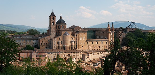
Urbino, a historic city in the Marche region of Italy, is surrounded by beautiful landscapes and offers various hiking opportunities for outdoor enthusiasts. Here are some key points about hiking in and around Urbino:...
- Country:
- Postal Code: 61029
- Local Dialing Code: 0722
- Licence Plate Code: PU
- Coordinates: 43° 43' 31" N, 12° 38' 14" E
- GPS tracks (wikiloc): [Link]
- AboveSeaLevel: 451 м m
- Area: 226.5 sq km
- Population: 14558
- Web site: [Link]