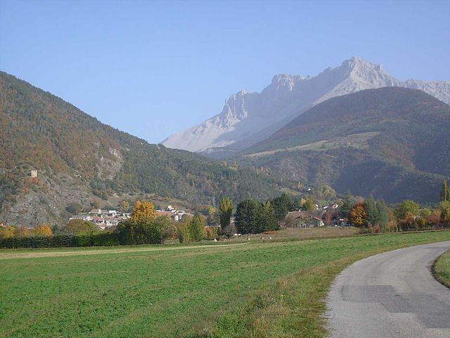
Agnières-en-Dévoluy (Agnières-en-Dévoluy)
- former commune in Hautes-Alpes, France
Agnières-en-Dévoluy is a beautiful village located in the Dévoluy mountain range in the French Alps. This region is known for its stunning landscapes, diverse flora and fauna, and a variety of hiking trails that cater to different skill levels. Here are some key points about hiking in Agnières-en-Dévoluy:
1.
- The area around Agnières-en-Dévoluy offers a range of hiking trails, from easy walks suitable for families to more challenging hikes for seasoned trekkers.
- Popular trails include routes that lead to mountain passes, lakes, and panoramic viewpoints that showcase the beauty of the Dévoluy mountains.
2.
- Many trails provide breathtaking views of the surrounding mountains and valleys. The landscape features limestone cliffs, alpine meadows, and dense forests.
- The nearby Dévoluy massif is particularly striking, and hikes often showcase its unique geological formations.
3.
- Hikers may encounter a variety of wildlife, including chamois, ibex, and a wide range of bird species. The area is rich in biodiversity, making it a great place for nature enthusiasts.
4.
- Summer (late June to September) is the prime hiking season when trails are fully accessible and weather conditions are generally favorable.
- In autumn, the foliage adds vibrant colors to the landscape. Winter hiking is also possible with the right equipment, but trails may be longer and more difficult due to snow.
5.
- Before heading out, it's essential to check trail conditions and weather forecasts.
- Consider bringing sufficient water, snacks, a map, and proper hiking gear. Some trails may benefit from hiking poles, especially if they are steep or rocky.
6.
- For those unfamiliar with the area, guided hikes can provide invaluable insights into the local ecosystem, culture, and history.
7.
- There are mountain refuges nearby where hikers can rest and enjoy meals. Staying overnight can allow for longer hiking trips and exploration of the area.
8.
- Engaging with local traditions and cuisine can enhance your hiking experience. Make time to explore Agnières-en-Dévoluy's village charm and its offerings.
Conclusion
Hiking in Agnières-en-Dévoluy is a rewarding experience for outdoor enthusiasts. Whether you’re looking for a leisurely stroll or a challenging trek, the region's natural beauty provides an excellent backdrop for adventure. Always remember to hike responsibly and leave no trace to preserve this stunning environment for future hikers. Enjoy your exploration!
- Country:

- Postal Code: 05250
- Coordinates: 44° 41' 42" N, 5° 52' 56" E


- GPS tracks (wikiloc): [Link]
- Population: 287
- Web site: http://www.cc-devoluy.com/agnieres/
- Wikipedia en: wiki(en)
- Wikipedia: wiki(fr)
- Wikidata storage: Wikidata: Q1017781
- Wikipedia Commons Category: [Link]
- Freebase ID: [/m/03mfkpz]
- Freebase ID: [/m/03mfkpz]
- Freebase ID: [/m/03mfkpz]
- GeoNames ID: Alt: [3038597]
- GeoNames ID: Alt: [3038597]
- GeoNames ID: Alt: [3038597]
- INSEE municipality code: 05002
- INSEE municipality code: 05002
- INSEE municipality code: 05002
Shares border with regions:

La Cluse
- former commune in Hautes-Alpes, France
La Cluse, often referred to as La Cluse and its surrounding areas, is a beautiful destination for hikers looking for scenic views, diverse landscapes, and unique geological features. Located in the Jura region of France, it is characterized by rugged terrain, forests, and panoramic views of both mountains and valleys....
- Country:

- Postal Code: 05250
- Coordinates: 44° 38' 25" N, 5° 50' 56" E


- GPS tracks (wikiloc): [Link]
- Population: 43

Saint-Disdier
- former commune in Hautes-Alpes, France
Saint-Disdier, located in the Hautes-Alpes region of France, offers a wonderful environment for hiking enthusiasts. Surrounded by the stunning landscapes of the Southern French Alps, the area is known for its picturesque trails, diverse ecosystems, and breathtaking views....
- Country:

- Postal Code: 05250
- Coordinates: 44° 44' 0" N, 5° 54' 0" E


- GPS tracks (wikiloc): [Link]
- AboveSeaLevel: 1040 м m
- Population: 139


Lus-la-Croix-Haute
- commune in Drôme, France
Lus-la-Croix-Haute is a beautiful destination for hiking enthusiasts, located in the picturesque Alps of France. This charming village offers a variety of trails that cater to different levels of hikers, from beginners to experienced adventurers....
- Country:

- Postal Code: 26620
- Coordinates: 44° 39' 55" N, 5° 42' 20" E


- GPS tracks (wikiloc): [Link]
- Area: 87.2 sq km
- Population: 549

Montmaur
- commune in Hautes-Alpes, France
Montmaur, located in the Hautes-Alpes department of France, offers a range of hiking opportunities for outdoor enthusiasts. Nestled in the picturesque French Alps, this area is characterized by stunning landscapes, diverse flora and fauna, and a variety of trails suitable for different skill levels....
- Country:

- Postal Code: 05400
- Coordinates: 44° 34' 16" N, 5° 52' 27" E


- GPS tracks (wikiloc): [Link]
- Area: 48.77 sq km
- Population: 515

Saint-Étienne-en-Dévoluy
- former commune in Hautes-Alpes, France
 Hiking in Saint-Étienne-en-Dévoluy
Saint-Étienne-en-Dévoluy is a lovely destination for hiking, located in the Dévoluy massif in the French Alps. This area offers a variety of trails suitable for all levels, from gentle walks to more challenging hikes, making it a perfect place for both beginners and experienced hikers....
- Country:

- Postal Code: 05250
- Coordinates: 44° 41' 36" N, 5° 56' 31" E


- GPS tracks (wikiloc): [Link]
- Population: 525
- Web site: [Link]