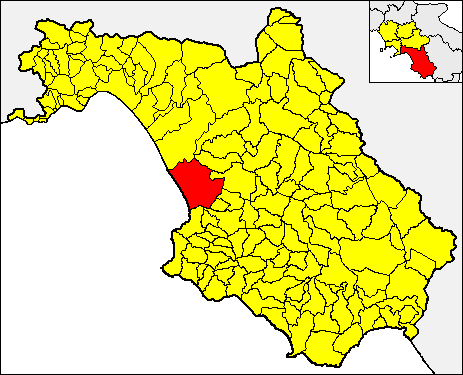
Agropoli (Agropoli)

- Italian comune
 Hiking in Agropoli
Agropoli, a charming coastal town in the Cilento region of Italy, offers fantastic opportunities for hiking enthusiasts. Nestled between the Tyrrhenian Sea and the rolling hills of the Cilento National Park, Agropoli features a variety of scenic trails that cater to different skill levels. Here are some things to consider when hiking in and around Agropoli:
Trails and Natural Features
-
Cilento National Park: Just a short distance from Agropoli, this UNESCO World Heritage site features numerous hiking trails that meander through lush forests, rocky cliffs, and along coastal paths. The park is home to diverse flora and fauna, and you can often spot local wildlife.
-
Coastal Hikes: The coastline near Agropoli boasts stunning views of the Mediterranean Sea. Coastal trails offer a unique experience, with opportunities to swim at picturesque beaches. The Sentiero dei Cerri, for example, is a beautiful coastal path that leads to splendid vistas.
-
Monte Tresino: This area offers trails that lead to the summit of Monte Tresino, where hikers can enjoy panoramic views of the coastline and surrounding countryside. The hike to the top provides a rewarding experience and can be moderately challenging.
-
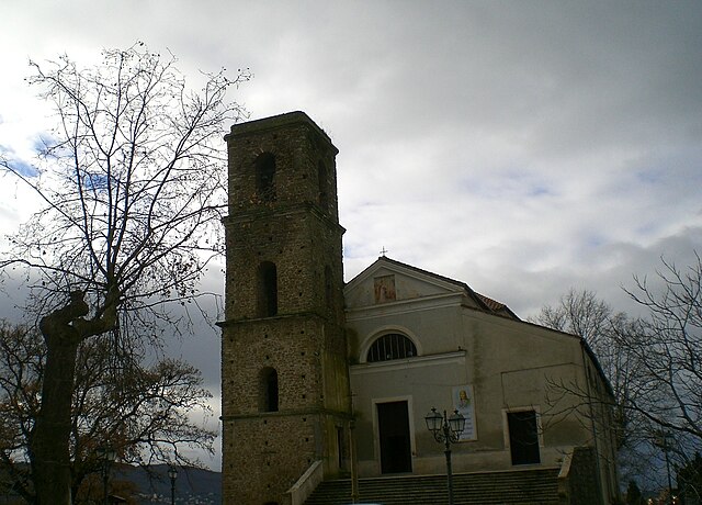
Historical Sites: Along the hiking trails, you can discover ancient ruins, such as the Agropoli Castle and remnants of Greek and Roman settlements, which add a cultural dimension to your hikes.
Practical Tips
-
Best Time to Go: The best time for hiking in Agropoli is during the spring (April to June) and autumn (September to October) when the weather is mild and pleasant.
-
Gear and Preparation: Wear comfortable hiking shoes, bring plenty of water, and pack snacks for your hike. Sun protection is essential, especially during summer months.
-
Guided Tours: If you're not familiar with the area, consider hiring a local guide or joining guided hiking tours. This can enhance your experience as they often share insights about the local culture, geography, and ecology.
-
Public Transport: Agropoli is accessible via train and bus from major cities, making it an easy starting point for hiking adventures in the region.
Safety Considerations
As with any hiking trip, prioritize safety. Be aware of your physical limits, stay on marked trails, and inform someone of your hiking plans if you’re going solo. Check local weather conditions and be prepared for changes.
Overall, Agropoli offers a unique blend of breathtaking landscapes, rich history, and diverse hiking opportunities, making it a beautiful destination for outdoor enthusiasts. Enjoy your hike!
- Country:

- Postal Code: 84043
- Local Dialing Code: 0974
- Licence Plate Code: SA
- Coordinates: 40° 21' 30" N, 14° 59' 0" E


- GPS tracks (wikiloc): [Link]
- AboveSeaLevel: 30 м m
- Area: 32.77 sq km
- Population: 21874
- Web site: http://www.comune.agropoli.sa.it
- Wikipedia en: wiki(en)
- Wikipedia: wiki(it)
- Wikidata storage: Wikidata: Q80544
- Wikipedia Commons Gallery: [Link]
- Wikipedia Commons Category: [Link]
- GeoNames ID: Alt: [6541176]
- VIAF ID: Alt: [242297198]
- OSM relation ID: [40441]
- Quora topic ID: [Agropoli]
- UN/LOCODE: [ITAGP]
- Digital Atlas of the Roman Empire ID: [16727]
- ISTAT ID: 065002
- Italian cadastre code: A091
Shares border with regions:

Capaccio
- Italian comune
Hiking in Capaccio
Capaccio Paestum, located in the Campania region of Italy, is an excellent destination for hiking, offering a rich combination of historical sites, natural beauty, and diverse landscapes. Here are some highlights and tips for hiking in this area:...
- Country:
- Postal Code: 84047
- Local Dialing Code: 0828
- Licence Plate Code: SA
- Coordinates: 40° 25' 0" N, 15° 5' 0" E
- GPS tracks (wikiloc): [Link]
- AboveSeaLevel: 0 м m
- Area: 113 sq km
- Population: 22802
- Web site: [Link]


Castellabate
- Italian comune
Hiking in Castellabate
Castellabate, located in the Cilento and Vallo di Diano National Park in southern Italy, is a stunning destination for hiking enthusiasts. This picturesque area offers a mix of coastal trails, scenic vistas, and inland paths through lush landscapes, making it ideal for all skill levels....
- Country:
- Postal Code: 84048
- Local Dialing Code: 0974
- Licence Plate Code: SA
- Coordinates: 40° 16' 45" N, 14° 57' 6" E
- GPS tracks (wikiloc): [Link]
- AboveSeaLevel: 289 м m
- Area: 37.43 sq km
- Population: 9233
- Web site: [Link]

Cicerale
- Italian comune
Hiking in Cicerale
Cicerale is a charming town located in the Campania region of Italy, known for its scenic landscapes and natural beauty. It offers a variety of hiking trails suitable for different skill levels, making it a great destination for both novice and experienced hikers....
- Country:
- Postal Code: 84053
- Local Dialing Code: 0974
- Licence Plate Code: SA
- Coordinates: 40° 21' 0" N, 15° 8' 0" E
- GPS tracks (wikiloc): [Link]
- AboveSeaLevel: 475 м m
- Area: 41.37 sq km
- Population: 1194
- Web site: [Link]
Laureana Cilento
- Italian comune
Hiking in Laureana Cilento
Laureana Cilento is a charming town located in the Cilento region of southern Italy, which is known for its stunning landscapes, rich history, and outdoor activities, including hiking. The area forms part of the Cilento and Vallo di Diano National Park, a UNESCO World Heritage site, offering a diverse range of trails that cater to different levels of experience....
- Country:
- Postal Code: 84050
- Local Dialing Code: 0974
- Licence Plate Code: SA
- Coordinates: 40° 18' 0" N, 15° 2' 0" E
- GPS tracks (wikiloc): [Link]
- AboveSeaLevel: 452 м m
- Area: 13.74 sq km
- Population: 1180
- Web site: [Link]


Ogliastro Cilento
- Italian comune
Hiking in Ogliastro Cilento
Ogliastro Cilento, located in the Cilento and Vallo di Diano National Park in southern Italy, is a hidden gem for hikers and nature enthusiasts. Here are some key aspects of hiking in this beautiful area:...
- Country:
- Postal Code: 84061
- Local Dialing Code: 0974
- Licence Plate Code: SA
- Coordinates: 40° 21' 0" N, 15° 3' 0" E
- GPS tracks (wikiloc): [Link]
- AboveSeaLevel: 365 м m
- Area: 13.24 sq km
- Population: 2250
- Web site: [Link]
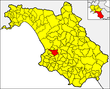
Prignano Cilento
- Italian comune
Hiking in Prignano Cilento
Prignano Cilento is a beautiful village located in the Cilento and Vallo di Diano National Park in Campania, southern Italy. This area is known for its stunning landscapes, rich biodiversity, and scenic hiking trails that cater to various skill levels....
- Country:
- Postal Code: 84060
- Local Dialing Code: 0974
- Licence Plate Code: SA
- Coordinates: 40° 20' 0" N, 15° 4' 0" E
- GPS tracks (wikiloc): [Link]
- AboveSeaLevel: 415 м m
- Area: 12.04 sq km
- Population: 1068
- Web site: [Link]
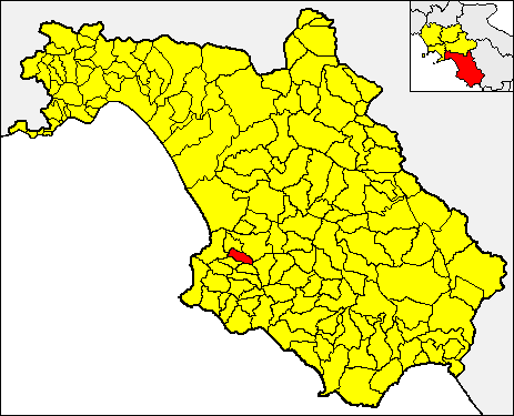
Torchiara
- Italian comune
Hiking in Torchiara
Torchiara, located in the Campania region of Italy, is surrounded by beautiful landscapes that are perfect for hiking. The area is part of the Cilento National Park, which offers a variety of trails suited for different levels of hikers. Here are some aspects to consider when hiking in Torchiara:...
- Country:
- Postal Code: 84076
- Local Dialing Code: 0974
- Licence Plate Code: SA
- Coordinates: 40° 19' 0" N, 15° 3' 0" E
- GPS tracks (wikiloc): [Link]
- AboveSeaLevel: 360 м m
- Area: 8.46 sq km
- Population: 1826
- Web site: [Link]