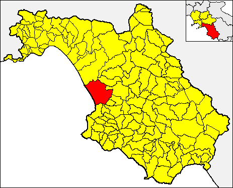
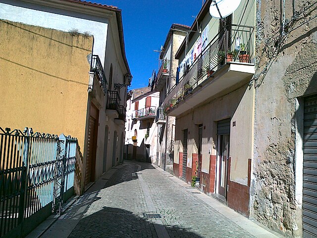
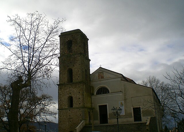
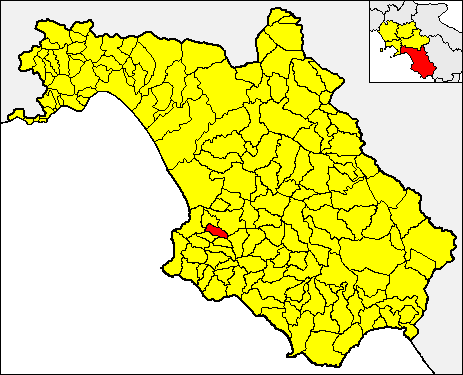
Cicerale (Cicerale)

- Italian comune
 Hiking in Cicerale
Cicerale is a charming town located in the Campania region of Italy, known for its scenic landscapes and natural beauty. It offers a variety of hiking trails suitable for different skill levels, making it a great destination for both novice and experienced hikers.
Hiking Highlights in Cicerale:
-
Natural Landscapes: The trails around Cicerale take you through lush forests, olive groves, and rolling hills that provide stunning views of the surrounding countryside and the nearby Cilento National Park.
-
Cilento and Vallo di Diano National Park: This UNESCO World Heritage site encompasses the area around Cicerale, offering a wealth of hiking opportunities. You can explore trails that lead to picturesque spots, ancient ruins, and breathtaking panoramas.
-
Local Flora and Fauna: As you hike, you'll encounter diverse plant species and wildlife typical of the Mediterranean climate. Keep an eye out for various bird species and the vibrant flora that thrives in the region.
-
Historic Trails: Some trails may connect you to historical sites and viewpoints where you can learn more about the area’s rich culture and history.
-
Cultural Experience: Hiking in Cicerale often allows you to interact with local communities, experience traditional Italian hospitality, and even sample local cuisine along the way.
Tips for Hiking in Cicerale:
-
Preparation: Make sure to wear appropriate hiking shoes, carry plenty of water, and bring snacks. A map or GPS device can be helpful, as some trails might not be well-marked.
-
Weather: Check the weather conditions before your hike, as they can change quickly in mountainous regions. Spring and autumn are generally the best times for hiking in this area.
-
Respect Nature: Stay on marked trails to preserve the environment, and carry out any trash to keep the trails clean.
-
Local Guides: If you’re unfamiliar with the area, consider hiring a local guide who can provide insights and ensure safety on more challenging routes.
Whether you're looking for a peaceful hiking experience or an adventurous trek, Cicerale offers a beautiful setting to explore the great outdoors in Italy.
- Country:

- Postal Code: 84053
- Local Dialing Code: 0974
- Licence Plate Code: SA
- Coordinates: 40° 21' 0" N, 15° 8' 0" E


- GPS tracks (wikiloc): [Link]
- AboveSeaLevel: 475 м m
- Area: 41.37 sq km
- Population: 1194
- Web site: http://www.comune.cicerale.sa.it/
- Wikipedia en: wiki(en)
- Wikipedia: wiki(it)
- Wikidata storage: Wikidata: Q80878
- Wikipedia Commons Category: [Link]
- Freebase ID: [/m/0frfh7]
- GeoNames ID: Alt: [6538203]
- OSM relation ID: [40448]
- WOEID: [714071]
- TGN ID: [7048071]
- ISTAT ID: 065042
- Italian cadastre code: C676
Shares border with regions:


Agropoli
- Italian comune
Hiking in Agropoli
Agropoli, a charming coastal town in the Cilento region of Italy, offers fantastic opportunities for hiking enthusiasts. Nestled between the Tyrrhenian Sea and the rolling hills of the Cilento National Park, Agropoli features a variety of scenic trails that cater to different skill levels. Here are some things to consider when hiking in and around Agropoli:...
- Country:
- Postal Code: 84043
- Local Dialing Code: 0974
- Licence Plate Code: SA
- Coordinates: 40° 21' 30" N, 14° 59' 0" E
- GPS tracks (wikiloc): [Link]
- AboveSeaLevel: 30 м m
- Area: 32.77 sq km
- Population: 21874
- Web site: [Link]

Capaccio
- Italian comune
Hiking in Capaccio
Capaccio Paestum, located in the Campania region of Italy, is an excellent destination for hiking, offering a rich combination of historical sites, natural beauty, and diverse landscapes. Here are some highlights and tips for hiking in this area:...
- Country:
- Postal Code: 84047
- Local Dialing Code: 0828
- Licence Plate Code: SA
- Coordinates: 40° 25' 0" N, 15° 5' 0" E
- GPS tracks (wikiloc): [Link]
- AboveSeaLevel: 0 м m
- Area: 113 sq km
- Population: 22802
- Web site: [Link]

Giungano
- Italian comune
Hiking in Giungano
Giungano is a charming village located in the Campania region of Italy, nestled within the Cilento National Park—a UNESCO World Heritage Site known for its stunning landscapes, coastal views, and rich biodiversity. Hiking in Giungano offers a unique blend of natural beauty, cultural heritage, and outdoor adventure. Here are some highlights and tips for hiking in this area:...
- Country:
- Postal Code: 84050
- Local Dialing Code: 0828
- Licence Plate Code: SA
- Coordinates: 40° 24' 0" N, 15° 7' 0" E
- GPS tracks (wikiloc): [Link]
- AboveSeaLevel: 250 м m
- Area: 11.7 sq km
- Population: 1321
- Web site: [Link]


Monteforte Cilento
- Italian comune
Hiking in Monteforte Cilento
Monteforte Cilento is a beautiful small village located in the Cilento and Vallo di Diano National Park in southern Italy. This area is renowned for its stunning landscapes, rich biodiversity, and historical significance, making it an excellent destination for hiking enthusiasts....
- Country:
- Postal Code: 84060
- Local Dialing Code: 0974
- Licence Plate Code: SA
- Coordinates: 40° 22' 0" N, 15° 12' 0" E
- GPS tracks (wikiloc): [Link]
- AboveSeaLevel: 600 м m
- Area: 22.17 sq km
- Population: 545
- Web site: [Link]


Ogliastro Cilento
- Italian comune
Hiking in Ogliastro Cilento
Ogliastro Cilento, located in the Cilento and Vallo di Diano National Park in southern Italy, is a hidden gem for hikers and nature enthusiasts. Here are some key aspects of hiking in this beautiful area:...
- Country:
- Postal Code: 84061
- Local Dialing Code: 0974
- Licence Plate Code: SA
- Coordinates: 40° 21' 0" N, 15° 3' 0" E
- GPS tracks (wikiloc): [Link]
- AboveSeaLevel: 365 м m
- Area: 13.24 sq km
- Population: 2250
- Web site: [Link]


Perito
- Italian comune
Hiking in Perito
Perito Moreno National Park, often simply referred to as Perito, is located in the province of Santa Cruz in Argentina. It's known for its stunning landscapes, which include mountains, glaciers, forests, and lakes. The park is a fantastic destination for hiking enthusiasts, offering a range of trails that cater to various skill levels....
- Country:
- Postal Code: 84060
- Local Dialing Code: 0974
- Licence Plate Code: SA
- Coordinates: 40° 18' 0" N, 15° 9' 0" E
- GPS tracks (wikiloc): [Link]
- AboveSeaLevel: 460 м m
- Area: 24 sq km
- Population: 898
- Web site: [Link]
Prignano Cilento
- Italian comune
Hiking in Prignano Cilento
Prignano Cilento is a beautiful village located in the Cilento and Vallo di Diano National Park in Campania, southern Italy. This area is known for its stunning landscapes, rich biodiversity, and scenic hiking trails that cater to various skill levels....
- Country:
- Postal Code: 84060
- Local Dialing Code: 0974
- Licence Plate Code: SA
- Coordinates: 40° 20' 0" N, 15° 4' 0" E
- GPS tracks (wikiloc): [Link]
- AboveSeaLevel: 415 м m
- Area: 12.04 sq km
- Population: 1068
- Web site: [Link]


Trentinara
- Italian comune
Hiking in Trentinara
Trentinara, a charming village in the Campania region of Italy, is known for its stunning landscapes and excellent hiking opportunities. Nestled in the Cilento and Vallo di Diano National Park, which is a UNESCO World Heritage site, Trentinara offers a variety of trails that cater to different skill levels, making it a great destination for both novice hikers and experienced trekkers....
- Country:
- Postal Code: 84070
- Local Dialing Code: 0828
- Licence Plate Code: SA
- Coordinates: 40° 24' 0" N, 15° 7' 0" E
- GPS tracks (wikiloc): [Link]
- AboveSeaLevel: 606 м m
- Area: 23.44 sq km
- Population: 1625
- Web site: [Link]