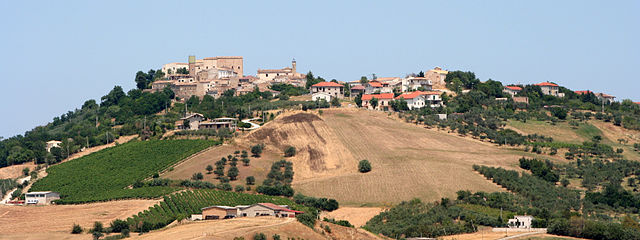
Alanno (Alanno)
.svg)
- Italian comune
 Hiking in Alanno
Alanno is a charming town located in the province of Pescara, in the Abruzzo region of Italy. It's surrounded by beautiful landscapes, making it a great destination for hiking enthusiasts. Here are some key points about hiking in and around Alanno:
Trails and Natural Beauty
- Scenic Views: The area offers stunning views of both the Apennine Mountains and the Adriatic coast, providing a diverse range of landscapes to explore.
- Trail Systems: There are several established trails around Alanno, ranging from easy walks to more strenuous hikes. Some popular trails may lead you through olive groves, vineyards, and forests.
- Protected Areas: Nearby natural parks, such as the Majella National Park and Gran Sasso National Park, offer more challenging and rewarding hiking routes with the opportunity to see unique flora and fauna.
Experience Levels
- Trails around Alanno can cater to various experience levels, from beginners to seasoned hikers.
- Beginners can enjoy well-marked, easy paths, while more experienced hikers may seek out more rugged terrain and higher altitudes.
Best Time to Hike
- The best months for hiking around Alanno are typically spring (April to June) and fall (September to October) when the weather is mild and the trails are less crowded.
- Summer can be hot, particularly in the valleys, so early morning hikes may be preferable.
Essential Tips
- Local Guidance: Consider hiring a local guide if you’re unfamiliar with the area. They can enhance your experience with insight into local culture and nature.
- Stay Hydrated: Always carry enough water, especially on longer hikes.
- Proper Footwear: Good hiking boots are recommended due to varying trail conditions.
- Respect Nature: Follow Leave No Trace principles to preserve the natural beauty of the area.
Attractions
In addition to hiking, there are historical sites and local cuisine to explore in Alanno. Make sure to take time to enjoy the local traditions and foods, which can enhance your overall experience.
Hiking in Alanno combines outdoor adventure with cultural richness, making it a wonderful destination for those looking to explore Italy's natural beauty.
- Country:

- Postal Code: 65020
- Local Dialing Code: 085
- Licence Plate Code: PE
- Coordinates: 42° 18' 0" N, 13° 58' 0" E


- GPS tracks (wikiloc): [Link]
- AboveSeaLevel: 307 м m
- Area: 32.53 sq km
- Population: 3466
- Web site: http://www.comune.alanno.pe.it
- Wikipedia en: wiki(en)
- Wikipedia: wiki(it)
- Wikidata storage: Wikidata: Q51346
- Wikipedia Commons Gallery: [Link]
- Wikipedia Commons Category: [Link]
- Freebase ID: [/m/0fg8bq]
- GeoNames ID: Alt: [6539596]
- OSM relation ID: [41915]
- UN/LOCODE: [ITZCH]
- ISTAT ID: 068002
- Italian cadastre code: A120
Shares border with regions:


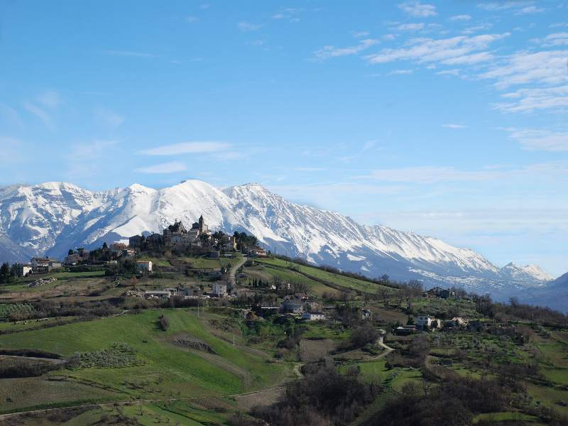
Cugnoli
- Italian comune
Hiking in Cugnoli
Cugnoli is a charming village located in the Abruzzo region of Italy, nestled in the picturesque Gran Sasso e Monti della Laga National Park. The region is known for its stunning landscapes, rich biodiversity, and well-marked hiking trails that cater to various skill levels. Here’s an overview of hiking in and around Cugnoli:...
- Country:
- Postal Code: 65020
- Local Dialing Code: 085
- Licence Plate Code: PE
- Coordinates: 42° 18' 30" N, 13° 55' 59" E
- GPS tracks (wikiloc): [Link]
- AboveSeaLevel: 331 м m
- Area: 15.96 sq km
- Population: 1466
- Web site: [Link]


Manoppello
- Italian comune
Hiking in Manoppello
Manoppello is a beautiful town in the Abruzzo region of Italy, known for its stunning landscapes and rich history. Hiking in this area provides an opportunity to explore picturesque trails that wind through the surrounding mountains, valleys, and natural parks. Here are some key points to consider for hiking in and around Manoppello:...
- Country:
- Postal Code: 65024
- Local Dialing Code: 085
- Licence Plate Code: PE
- Coordinates: 42° 15' 28" N, 14° 3' 35" E
- GPS tracks (wikiloc): [Link]
- AboveSeaLevel: 217 м m
- Area: 39.26 sq km
- Population: 6920
- Web site: [Link]

Nocciano
- Italian comune
Hiking in Nocciano
Nocciano, a charming town in the Abruzzo region of Italy, offers a variety of opportunities for hiking enthusiasts. The surrounding countryside is characterized by rolling hills, vineyards, and scenic views of the Majella and Gran Sasso mountain ranges, making it an excellent destination for outdoor activities....
- Country:
- Postal Code: 65010
- Local Dialing Code: 085
- Licence Plate Code: PE
- Coordinates: 42° 20' 0" N, 13° 59' 0" E
- GPS tracks (wikiloc): [Link]
- AboveSeaLevel: 301 м m
- Area: 13.76 sq km
- Population: 1796
- Web site: [Link]

Pietranico
- Italian comune
Hiking in Pietranico
Pietranico is a small village located in the Abruzzo region of Italy, surrounded by stunning natural landscapes that are perfect for hiking enthusiasts. Nestled in the foothills of the Gran Sasso mountain range, Pietranico offers a variety of trails suitable for different skill levels, from leisurely walks to more challenging hikes....
- Country:
- Postal Code: 65020
- Local Dialing Code: 085
- Licence Plate Code: PE
- Coordinates: 42° 17' 0" N, 13° 55' 0" E
- GPS tracks (wikiloc): [Link]
- AboveSeaLevel: 590 м m
- Area: 14.77 sq km
- Population: 477
- Web site: [Link]


Rosciano
- Italian comune
Hiking in Rosciano
Rosciano, located in the Abruzzo region of Italy, is a fantastic destination for hiking, thanks to its picturesque landscapes, rolling hills, and proximity to both mountains and coastal areas. Here are some highlights and tips for hiking in and around Rosciano:...
- Country:
- Postal Code: 65020
- Local Dialing Code: 085
- Licence Plate Code: PE
- Coordinates: 42° 19' 20" N, 14° 2' 44" E
- GPS tracks (wikiloc): [Link]
- AboveSeaLevel: 253 м m
- Area: 27.79 sq km
- Population: 3949
- Web site: [Link]
Scafa
- Italian comune
Hiking in Scafa
Scafa, located in the Abruzzo region of Italy, is a charming destination for hiking enthusiasts. Nestled near the foothills of the Apennine Mountains, it offers access to a variety of natural landscapes, from rolling hills to more rugged terrain....
- Country:
- Postal Code: 65027
- Local Dialing Code: 085
- Licence Plate Code: PE
- Coordinates: 42° 15' 57" N, 13° 59' 48" E
- GPS tracks (wikiloc): [Link]
- AboveSeaLevel: 108 м m
- Area: 10.34 sq km
- Population: 3656
- Web site: [Link]


Torre de' Passeri
- Italian comune
Hiking in Torre de' Passeri
Torre de' Passeri is a picturesque town located in the Abruzzo region of Italy, nestled within the beautiful Apennine Mountains. Hiking in and around Torre de' Passeri offers a mix of scenic landscapes, cultural experiences, and opportunities to explore the natural beauty of the region....
- Country:
- Postal Code: 65029
- Local Dialing Code: 085
- Licence Plate Code: PE
- Coordinates: 42° 14' 0" N, 13° 56' 0" E
- GPS tracks (wikiloc): [Link]
- AboveSeaLevel: 172 м m
- Area: 5.92 sq km
- Population: 3045
- Web site: [Link]
Turrivalignani
- Italian comune
Hiking in Turrivalignani
Turrivalignani is a picturesque village located in the Abruzzo region of Italy, known for its beautiful landscapes and outdoor recreational opportunities, including hiking. Here are some highlights related to hiking in and around Turrivalignani:...
- Country:
- Postal Code: 65020
- Local Dialing Code: 085
- Licence Plate Code: PE
- Coordinates: 42° 16' 0" N, 14° 2' 0" E
- GPS tracks (wikiloc): [Link]
- AboveSeaLevel: 312 м m
- Area: 6.11 sq km
- Population: 887
- Web site: [Link]