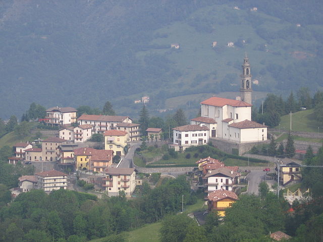
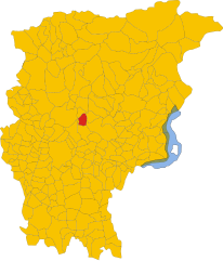
Algua (Algua)
.svg)
- Italian comune
 Hiking in Algua
It seems there might be a typo in your query, as "Algua" doesn’t correspond to any well-known hiking destination or region. However, if you meant a specific area, such as "Algarve" in Portugal, "Alguacil" in Spain, or "Algul" in another region, please clarify.
If you are referring to a popular hiking location, I can provide details on trails, scenery, tips, and other useful information once I have the correct name. Let me know!
- Country:

- Postal Code: 24010
- Local Dialing Code: 0345
- Licence Plate Code: BG
- Coordinates: 45° 50' 0" N, 9° 43' 0" E


- GPS tracks (wikiloc): [Link]
- AboveSeaLevel: 432 м m
- Area: 8.32 sq km
- Population: 673
- Web site: http://www.comune.algua.bg.it
- Wikipedia en: wiki(en)
- Wikipedia: wiki(it)
- Wikidata storage: Wikidata: Q95059
- Wikipedia Commons Gallery: [Link]
- Wikipedia Commons Category: [Link]
- Freebase ID: [/m/0gjf_d]
- GeoNames ID: Alt: [6542588]
- OSM relation ID: [46131]
- ISTAT ID: 016248
- Italian cadastre code: A193
Shares border with regions:

Costa di Serina
- Italian comune
Hiking in Costa di Serina
Costa Serina, located in the province of Bergamo in the Lombardy region of Italy, is a beautiful destination for hiking enthusiasts. Nestled in the scenic foothills of the Alps, it offers a variety of trails that cater to different levels of experience, from casual walkers to seasoned hikers. Here are some key details about hiking in this area:...
- Country:
- Postal Code: 24010
- Local Dialing Code: 0345
- Licence Plate Code: BG
- Coordinates: 45° 49' 58" N, 9° 44' 30" E
- GPS tracks (wikiloc): [Link]
- AboveSeaLevel: 868 м m
- Area: 12.3 sq km
- Population: 912
- Web site: [Link]


Nembro
- Italian comune
Hiking in Nembro
Nembro is a charming town located in the province of Bergamo, in the Lombardy region of northern Italy. It is surrounded by beautiful natural landscapes, making it a great destination for hiking enthusiasts. Here are some details about hiking in and around Nembro:...
- Country:
- Postal Code: 24027
- Local Dialing Code: 035
- Licence Plate Code: BG
- Coordinates: 45° 44' 38" N, 9° 45' 34" E
- GPS tracks (wikiloc): [Link]
- AboveSeaLevel: 309 м m
- Area: 15.24 sq km
- Population: 11530
- Web site: [Link]


San Pellegrino Terme
- Italian comune
Hiking in San Pellegrino Terme
San Pellegrino Terme, located in the Lombardy region of Italy, is known for its thermal springs and beautiful natural landscapes, making it an excellent destination for hiking enthusiasts. Here are some highlights of hiking in this picturesque area:...
- Country:
- Postal Code: 24016
- Local Dialing Code: 0345
- Licence Plate Code: BG
- Coordinates: 45° 50' 0" N, 9° 40' 0" E
- GPS tracks (wikiloc): [Link]
- AboveSeaLevel: 358 м m
- Area: 22.95 sq km
- Population: 4827
- Web site: [Link]

Selvino
- Italian comune
Hiking in Selvino
Selvino, located in the Bergamo Alps of northern Italy, is a charming destination for hiking enthusiasts. Nestled in the Orobie Mountains, it offers stunning views, diverse landscapes, and a variety of trails suitable for all skill levels. Here’s what you can expect when hiking in Selvino:...
- Country:
- Postal Code: 24020
- Local Dialing Code: 035
- Licence Plate Code: BG
- Coordinates: 45° 47' 0" N, 9° 45' 0" E
- GPS tracks (wikiloc): [Link]
- AboveSeaLevel: 960 м m
- Area: 6.53 sq km
- Population: 2044
- Web site: [Link]


Serina, Lombardy
- Italian comune
Hiking in Serina, Lombardy
Serina, located in the Lombardy region of Italy, is a beautiful area for hiking enthusiasts. Nestled in the Seriana Valley, Serina offers stunning landscapes characterized by lush forests, rocky escarpments, and panoramic views of the surrounding mountains. Here are some key points to consider if you're planning a hiking trip to Serina:...
- Country:
- Postal Code: 24017
- Local Dialing Code: 0345
- Licence Plate Code: BG
- Coordinates: 45° 52' 0" N, 9° 44' 0" E
- GPS tracks (wikiloc): [Link]
- AboveSeaLevel: 720 м m
- Area: 27.34 sq km
- Population: 2077
- Web site: [Link]


Zogno
- Italian comune
Hiking in Zogno
Zogno is a charming village located in the province of Bergamo, Lombardy, Italy. Nestled in the Seriana Valley, it offers stunning landscapes, rich history, and a variety of hiking trails that cater to different skill levels. Here’s an overview of what you can expect when hiking in Zogno:...
- Country:
- Postal Code: 24019
- Local Dialing Code: 0345
- Licence Plate Code: BG
- Coordinates: 45° 47' 38" N, 9° 39' 56" E
- GPS tracks (wikiloc): [Link]
- AboveSeaLevel: 334 м m
- Area: 35.21 sq km
- Population: 8926
- Web site: [Link]


Aviatico
- Italian comune
Hiking in Aviatico
Aviatico is a charming municipality located in the province of Bergamo, in the Lombardy region of Italy. It's situated in the foothills of the Orobie Alps, making it an excellent destination for hiking enthusiasts. Here are some key highlights and tips about hiking in Aviatico:...
- Country:
- Postal Code: 24020
- Local Dialing Code: 035
- Licence Plate Code: BG
- Coordinates: 45° 48' 2" N, 9° 46' 16" E
- GPS tracks (wikiloc): [Link]
- AboveSeaLevel: 1022 м m
- Area: 8.49 sq km
- Population: 568
- Web site: [Link]


Bracca
- Italian comune
Hiking in Bracca
Bracca is a charming town located in the province of Bergamo in Lombardy, Italy. It's nestled in the foothills of the Central Alps and offers a variety of hiking opportunities for outdoor enthusiasts. Here are some highlights about hiking in and around Bracca:...
- Country:
- Postal Code: 24010
- Local Dialing Code: 0345
- Licence Plate Code: BG
- Coordinates: 45° 49' 0" N, 9° 43' 0" E
- GPS tracks (wikiloc): [Link]
- AboveSeaLevel: 400 м m
- Area: 5.47 sq km
- Population: 706
- Web site: [Link]