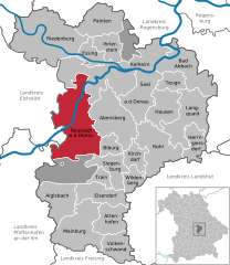
Altmannstein (Altmannstein)

- municipality of Germany
 Hiking in Altmannstein
Altmannstein, located in Bavaria, Germany, is a wonderful destination for hiking enthusiasts. Nestled in the picturesque landscape of the Danube Valley, this area offers a variety of trails suitable for different skill levels. Here are some key points about hiking in Altmannstein:
Trails and Routes
-
Scenic Views: The trails often wind through beautiful forests, past meadows, and along the banks of the Danube River, providing stunning views and opportunities for photography.
-
Difficulty Levels: You can find a range of hiking routes, from easy walks suitable for families to more challenging hikes for experienced trekkers.
-
Marked Paths: The trails in this region are well-marked, making it easier for hikers to navigate. Look for signs indicating the direction and length of each trail.
Points of Interest
- Natural Attractions: Be sure to explore local natural preserves, riverside areas, and possibly nearby hills or viewpoints that offer panoramic views of the surrounding landscape.
- Cultural Sites: Along the hiking routes, you may encounter historical landmarks, charming villages, and traditional Bavarian architecture.
Safety Tips
- Weather Preparedness: Check the weather forecast before heading out, as conditions can change rapidly.
- Gear Up Properly: Wear sturdy hiking boots, and consider bringing trekking poles for stability, especially on uneven terrain.
- Stay Hydrated: Carry sufficient water and snacks, particularly on longer hikes.
Best Times to Hike
- Spring and Fall: These seasons typically offer mild weather and beautiful scenery with blooming flowers in spring and vibrant foliage in autumn.
- Summer: While it can be hot, early morning or late afternoon hikes are pleasant.
Whether you're a local resident or a visitor, Altmannstein's hiking potential provides a great way to explore the natural beauty of Bavaria. Enjoy the great outdoors!
- Country:

- Postal Code: 93336
- Local Dialing Code: 09446; 08468
- Licence Plate Code: EI
- Coordinates: 48° 54' 0" N, 11° 39' 0" E


- GPS tracks (wikiloc): [Link]
- AboveSeaLevel: 388 м m
- Area: 114.29 sq km
- Population: 5892
- Web site: http://www.altmannstein.de/
- Wikipedia en: wiki(en)
- Wikipedia: wiki(de)
- Wikidata storage: Wikidata: Q442666
- Wikipedia Commons Category: [Link]
- Freebase ID: [/m/02q1fhy]
- GeoNames ID: Alt: [2957001]
- VIAF ID: Alt: [145561304]
- OSM relation ID: [943548]
- GND ID: Alt: [4219756-9]
- archINFORM location ID: [13285]
- Library of Congress authority ID: Alt: [n92061513]
- MusicBrainz area ID: [9805c200-bf07-408b-92ab-54171e4af262]
- WOEID: [634787]
- Historical Gazetteer (GOV) ID: [ALTEI1JN58TV]
- Bavarikon ID: [ODB_A00001012]
- German municipality key: 09176112
Shares border with regions:


Denkendorf, Bavaria
- municipality of Germany
Hiking in Denkendorf, Bavaria
Denkendorf, located in Bavaria, Germany, is a charming area that offers access to beautiful hiking trails and the stunning natural landscapes of the region. Here are some highlights about hiking in Denkendorf:...
- Country:
- Postal Code: 85095
- Local Dialing Code: 08466
- Licence Plate Code: EI
- Coordinates: 48° 55' 38" N, 11° 27' 44" E
- GPS tracks (wikiloc): [Link]
- AboveSeaLevel: 527 м m
- Area: 47.88 sq km
- Population: 4513
- Web site: [Link]

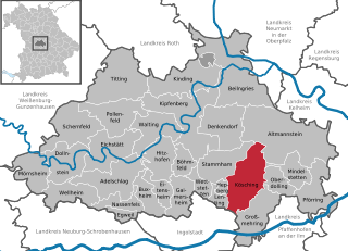
Neustadt an der Donau
- municipality of Germany
Hiking in Neustadt an der Donau
Neustadt an der Donau, located in Bavaria, Germany, is a charming area that offers a variety of hiking opportunities, thanks to its scenic landscapes, historic sites, and proximity to the Danube River. Here's what you should know when planning your hiking adventures in and around Neustadt an der Donau:...
- Country:
- Postal Code: 93333
- Local Dialing Code: 09445
- Licence Plate Code: KEH
- Coordinates: 48° 48' 25" N, 11° 46' 10" E
- GPS tracks (wikiloc): [Link]
- AboveSeaLevel: 357 м m
- Area: 93.55 sq km
- Population: 9811
- Web site: [Link]


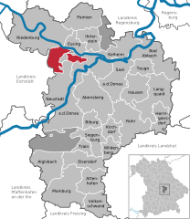
Riedenburg
- municipality of Germany
Hiking in Riedenburg
Riedenburg, located in Bavaria, Germany, is a charming town surrounded by beautiful landscapes, making it a fantastic destination for hiking enthusiasts. Here are some highlights and tips for hiking in the area:...
- Country:
- Postal Code: 93339
- Local Dialing Code: 09442
- Coordinates: 48° 58' 0" N, 11° 40' 0" E
- GPS tracks (wikiloc): [Link]
- AboveSeaLevel: 360 м m
- Area: 100.3 sq km
- Population: 4878
- Web site: [Link]


Pförring
- municipality in Bavaria, Germany
Hiking in Pförring
Pförring, located in Bavaria, Germany, is a quaint town surrounded by scenic landscapes that can be appealing for hikers. While there may not be extensive hiking trails specifically in Pförring itself, the surrounding areas offer beautiful countryside and potential routes for outdoor enthusiasts....
- Country:
- Postal Code: 85104; W-8071; 8071
- Local Dialing Code: 08403
- Licence Plate Code: EI
- Coordinates: 48° 48' 30" N, 11° 41' 24" E
- GPS tracks (wikiloc): [Link]
- AboveSeaLevel: 356 м m
- Area: 43.54 sq km
- Population: 2881
- Web site: [Link]


Mindelstetten
- municipality of Germany
Hiking in Mindelstetten
Mindelstetten is a small town located in Bavaria, Germany, known for its picturesque landscapes and proximity to nature. While it may not be a major hiking destination compared to larger national parks, there are still opportunities for enjoyable hikes in and around the area....
- Country:
- Postal Code: 93349
- Local Dialing Code: 08404
- Licence Plate Code: EI
- Coordinates: 48° 51' 0" N, 11° 39' 0" E
- GPS tracks (wikiloc): [Link]
- AboveSeaLevel: 403 м m
- Area: 22.72 sq km
- Population: 1273
- Web site: [Link]

Kösching
- municipality of Germany
Hiking in Kösching
Kösching is a charming town located in Bavaria, Germany, known for its picturesque landscapes and proximity to the Danube River. While it may not be as famous for hiking as some other regions in Germany, there are still delightful trails and natural spots for outdoor enthusiasts to explore....
- Country:
- Postal Code: 85092; W-8071; W-8073; 8071; 8073
- Local Dialing Code: 08456
- Licence Plate Code: EI
- Coordinates: 48° 49' 0" N, 11° 30' 0" E
- GPS tracks (wikiloc): [Link]
- AboveSeaLevel: 390 м m
- Area: 55.60 sq km
- Population: 5335
- Web site: [Link]


Beilngries
- town in Bavaria, Germany
Hiking in Beilngries
Beilngries, located in Bavaria, Germany, is a charming destination for hiking enthusiasts. Nestled between the Altmühltal Nature Park and the surrounding hills, it offers a variety of scenic trails that cater to different skill levels. Here are some highlights and tips for hiking in Beilngries:...
- Country:
- Postal Code: 92339
- Local Dialing Code: 08461
- Licence Plate Code: EI
- Coordinates: 49° 2' 0" N, 11° 28' 0" E
- GPS tracks (wikiloc): [Link]
- AboveSeaLevel: 368 м m
- Area: 100.13 sq km
- Population: 9258
- Web site: [Link]
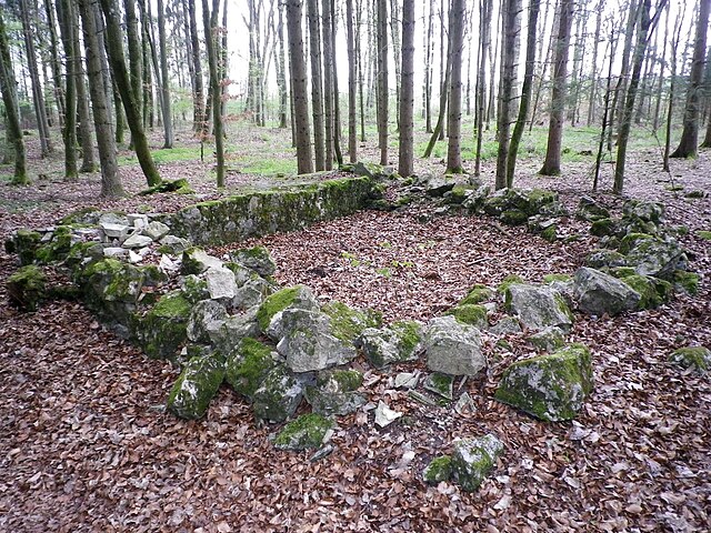
Hienheimer Forst
- unincorporated area in Germany
Hiking in Hienheimer Forst
Hienheimer Forst is a beautiful forested area located in Germany, primarily known for its picturesque landscapes and rich biodiversity. When planning a hiking trip in Hienheimer Forst, here are some key points to consider:...
- Country:
- Coordinates: 48° 54' 0" N, 11° 44' 0" E
- GPS tracks (wikiloc): [Link]