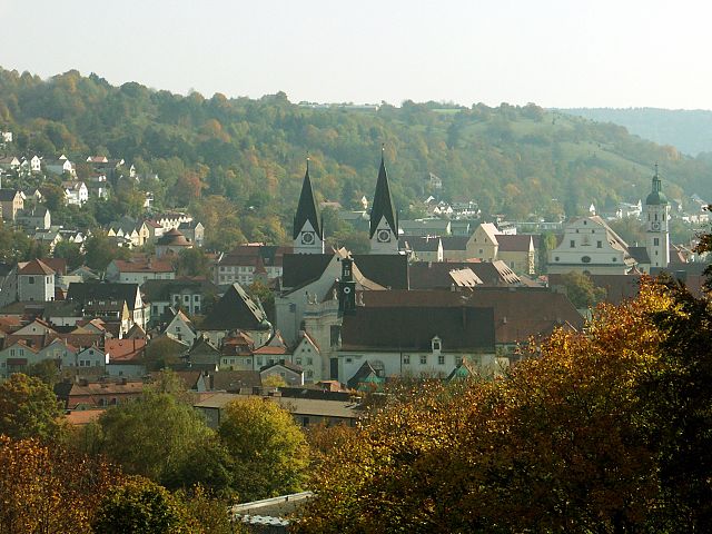
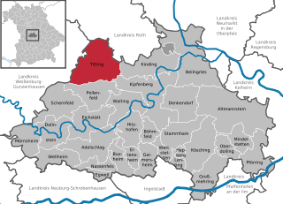
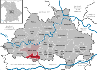
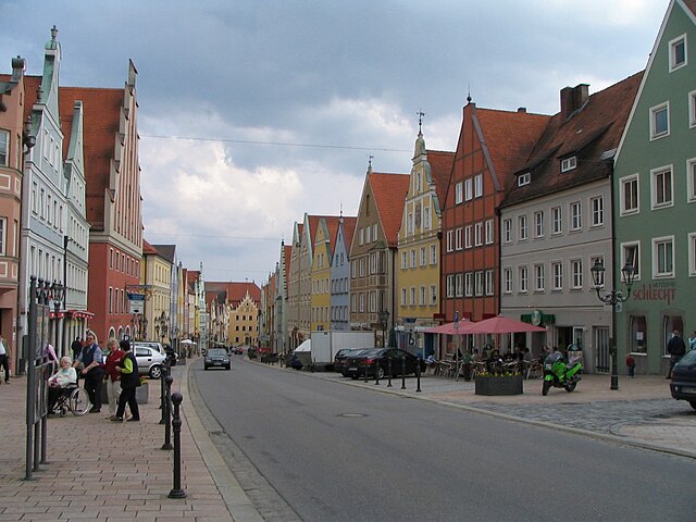
Eichstätt (Landkreis Eichstätt)

- district of Bavaria, Germany
 Hiking in Eichstätt
Eichstätt, located in Bavaria, Germany, is known for its scenic landscapes, historical towns, and rich natural beauty, making it a fantastic destination for hiking enthusiasts. Here are some highlights and tips for hiking in the Eichstätt district:
Scenic Trails
-
Altmühltal Nature Park: This park is a central feature of the region, offering numerous hiking trails that wind through beautiful valleys, limestone hills, and along the Altmühl River. The park is known for its diverse flora and fauna as well as its geological formations.
-
Jurassic Geopark Trails: Eichstätt is part of the Jurassic Geopark, where you can explore trails that showcase unique geological features like fossil sites and impressive rock formations.
-
The 1st Bavarian Hiking Trail: This trail offers a mix of nature and culture, taking you through charming villages, historical sites, and stunning countryside.
Historical Sites
While hiking, you can stumble upon various historical landmarks, such as:
- The Baroque town of Eichstätt itself, with its charming architecture and the beautiful Willibaldsburg fortress.
- The ancient Roman ruins nearby, which are often incorporated into the hiking routes.
Trail Difficulty
The hiking trails in the Eichstätt district range from easy walks suitable for families to more challenging paths for experienced hikers. Always check trail descriptions and difficulty levels to ensure you choose a hike that matches your skill level.
Wildlife and Nature
Eichstätt is home to rich biodiversity, and you may spot various birds, butterflies, and local wildlife while hiking. Spring and summer are particularly beautiful for wildflowers and lush green scenery.
Planning Your Hike
- Maps and Resources: Before heading out, consider investing in a detailed hiking map of the region. Local tourist information centers can also provide insights and resources.
- Weather Considerations: The best time for hiking typically spans from spring to early autumn. Always check the weather forecast and dress appropriately for the conditions.
- Hiking Gear: Good hiking shoes, enough water, and snacks are essential for a comfortable hiking experience. A first-aid kit and navigation tools are also recommended.
Community and Events
Eichstätt often hosts hiking events and theme trails that can enhance your experience. Engaging with local hiking groups can provide insights and companionship on your hikes.
Overall, hiking in the Eichstätt district offers a wonderful blend of nature, history, and adventure, making it ideal for both casual walkers and serious hikers alike. Don’t forget to take your camera to capture the stunning views along the way!
- Country:

- Capital: Eichstätt
- Licence Plate Code: EI
- Coordinates: 48° 55' 12" N, 11° 19' 48" E


- GPS tracks (wikiloc): [Link]
- AboveSeaLevel: 475 м m
- Area: 1214.00 sq km
- Population: 97347
- Web site: http://www.landkreis-eichstaett.de
- Wikipedia en: wiki(en)
- Wikipedia: wiki(de)
- Wikidata storage: Wikidata: Q10491
- Wikipedia Commons Category: [Link]
- Freebase ID: [/m/01m53x]
- GeoNames ID: Alt: [3220830]
- VIAF ID: Alt: [130255842]
- OSM relation ID: [62684]
- GND ID: Alt: [4013727-2]
- archINFORM location ID: [2396]
- Library of Congress authority ID: Alt: [n85241834]
- Quora topic ID: [Eichstätt]
- TGN ID: [7077299]
- Bavarikon ID: [ODB_A00001010]
- ISNI: Alt: [0000 0004 0480 3230]
- NUTS code: [DE219]
- BabelNet ID: [01944294n]
- German district key: 09176
Includes regions:

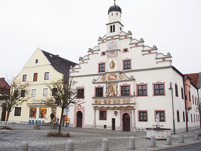
Eichstätt
- town in Bavaria, Germany
Hiking in Eichstätt
Eichstätt, located in the heart of Bavaria, Germany, offers a variety of hiking opportunities that showcase its stunning natural landscapes, historical sites, and unique limestone formations. Here are some highlights and tips for hiking in the Eichstätt area:...
- Country:
- Postal Code: 85072
- Local Dialing Code: 08421
- Licence Plate Code: EI
- Coordinates: 48° 53' 31" N, 11° 11' 2" E
- GPS tracks (wikiloc): [Link]
- AboveSeaLevel: 371 м m
- Area: 47.84 sq km
- Population: 13788
- Web site: [Link]


Denkendorf, Bavaria
- municipality of Germany
Hiking in Denkendorf, Bavaria
Denkendorf, located in Bavaria, Germany, is a charming area that offers access to beautiful hiking trails and the stunning natural landscapes of the region. Here are some highlights about hiking in Denkendorf:...
- Country:
- Postal Code: 85095
- Local Dialing Code: 08466
- Licence Plate Code: EI
- Coordinates: 48° 55' 38" N, 11° 27' 44" E
- GPS tracks (wikiloc): [Link]
- AboveSeaLevel: 527 м m
- Area: 47.88 sq km
- Population: 4513
- Web site: [Link]


Eitensheim
- municipality of Germany
Hiking in Eitensheim
Eitensheim is a small municipality located in Bavaria, Germany, near the beautiful countryside and the town of Ingolstadt. While it may not be as widely known as some other hiking destinations, the region offers various opportunities for outdoor enthusiasts....
- Country:
- Postal Code: 85117; W-8071; 8071
- Local Dialing Code: 08458
- Licence Plate Code: EI
- Coordinates: 48° 49' 0" N, 11° 19' 0" E
- GPS tracks (wikiloc): [Link]
- AboveSeaLevel: 403 м m
- Area: 15.72 sq km
- Population: 1538
- Web site: [Link]


Oberdolling
- municipality of Germany
Hiking in Oberdolling
Oberdolling is a picturesque village in Bavaria, Germany, surrounded by lush landscapes, making it an excellent location for hiking enthusiasts. While it may not be as widely known as some other hiking destinations in the region, there are still several trails and opportunities to explore the natural beauty of the area....
- Country:
- Postal Code: 85129; W-8071; 8071
- Local Dialing Code: 08404
- Licence Plate Code: EI
- Coordinates: 48° 50' 0" N, 11° 35' 0" E
- GPS tracks (wikiloc): [Link]
- AboveSeaLevel: 382 м m
- Area: 19.36 sq km
- Population: 826
- Web site: [Link]


Großmehring
- municipality in Bavaria, Germany
Hiking in Großmehring
Großmehring, located in Bavaria, Germany, is a charming area perfect for hiking enthusiasts. Nestled near the Danube River, it boasts scenic landscapes, lush greenery, and several trails that cater to all levels of hikers....
- Country:
- Postal Code: 85098; W-8071; 8071
- Local Dialing Code: 08407
- Licence Plate Code: EI
- Coordinates: 48° 46' 0" N, 11° 31' 59" E
- GPS tracks (wikiloc): [Link]
- AboveSeaLevel: 375 м m
- Area: 47.38 sq km
- Population: 4053
- Web site: [Link]


Adelschlag
- municipality of Germany
Hiking in Adelschlag
Adelschlag is a small municipality located in Bavaria, Germany, and while it may not be widely known as a major hiking destination, it offers a tranquil setting for outdoor enthusiasts, especially those who enjoy hiking in quieter, less crowded areas....
- Country:
- Postal Code: 85111
- Local Dialing Code: 08424
- Licence Plate Code: EI
- Coordinates: 48° 50' 0" N, 11° 13' 0" E
- GPS tracks (wikiloc): [Link]
- AboveSeaLevel: 435 м m
- Area: 51.95 sq km
- Population: 3000
- Web site: [Link]


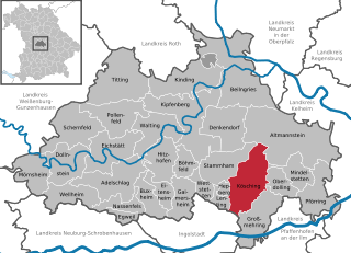
Altmannstein
- municipality of Germany
Hiking in Altmannstein
Altmannstein, located in Bavaria, Germany, is a wonderful destination for hiking enthusiasts. Nestled in the picturesque landscape of the Danube Valley, this area offers a variety of trails suitable for different skill levels. Here are some key points about hiking in Altmannstein:...
- Country:
- Postal Code: 93336
- Local Dialing Code: 09446; 08468
- Licence Plate Code: EI
- Coordinates: 48° 54' 0" N, 11° 39' 0" E
- GPS tracks (wikiloc): [Link]
- AboveSeaLevel: 388 м m
- Area: 114.29 sq km
- Population: 5892
- Web site: [Link]

Titting
- municipality of Germany
Hiking in Titting
Titting is a small village located in Bavaria, Germany, which may not be widely known as a hiking destination, but it is surrounded by beautiful natural landscapes that can offer rewarding hiking experiences. While specific hiking trails in Titting itself may be less well-documented, you can explore various options in the nearby regions....
- Country:
- Postal Code: 85135
- Local Dialing Code: 08423
- Licence Plate Code: EI
- Coordinates: 49° 0' 0" N, 11° 13' 0" E
- GPS tracks (wikiloc): [Link]
- AboveSeaLevel: 447 м m
- Area: 71.09 sq km
- Population: 2433
- Web site: [Link]


Pförring
- municipality in Bavaria, Germany
Hiking in Pförring
Pförring, located in Bavaria, Germany, is a quaint town surrounded by scenic landscapes that can be appealing for hikers. While there may not be extensive hiking trails specifically in Pförring itself, the surrounding areas offer beautiful countryside and potential routes for outdoor enthusiasts....
- Country:
- Postal Code: 85104; W-8071; 8071
- Local Dialing Code: 08403
- Licence Plate Code: EI
- Coordinates: 48° 48' 30" N, 11° 41' 24" E
- GPS tracks (wikiloc): [Link]
- AboveSeaLevel: 356 м m
- Area: 43.54 sq km
- Population: 2881
- Web site: [Link]


Kipfenberg
- municipality of Germany
Hiking in Kipfenberg
Kipfenberg, located in Bavaria, Germany, is a charming destination for hiking enthusiasts. Nestled in the Altmühltal Natural Park, it features a variety of landscapes including rolling hills, forested areas, and scenic views of the surrounding valleys. Here are some aspects to consider when planning a hiking trip in Kipfenberg:...
- Country:
- Postal Code: 85110
- Local Dialing Code: 08465
- Licence Plate Code: EI
- Coordinates: 48° 56' 58" N, 11° 23' 42" E
- GPS tracks (wikiloc): [Link]
- AboveSeaLevel: 378 м m
- Area: 81.43 sq km
- Population: 4149
- Web site: [Link]

Hepberg
- municipality of Germany
Hiking in Hepberg
Hepberg, located in Bavaria, Germany, is surrounded by scenic landscapes that make it an appealing destination for hikers looking to enjoy nature. While there may not be extensive organized trails directly in Hepberg itself, the surrounding areas offer various hiking opportunities that can be explored....
- Country:
- Postal Code: 85120; W-8071; 8071
- Local Dialing Code: 08456
- Licence Plate Code: EI
- Coordinates: 48° 49' 0" N, 11° 28' 0" E
- GPS tracks (wikiloc): [Link]
- AboveSeaLevel: 430 м m
- Area: 4.16 sq km
- Population: 1118
- Web site: [Link]


Mindelstetten
- municipality of Germany
Hiking in Mindelstetten
Mindelstetten is a small town located in Bavaria, Germany, known for its picturesque landscapes and proximity to nature. While it may not be a major hiking destination compared to larger national parks, there are still opportunities for enjoyable hikes in and around the area....
- Country:
- Postal Code: 93349
- Local Dialing Code: 08404
- Licence Plate Code: EI
- Coordinates: 48° 51' 0" N, 11° 39' 0" E
- GPS tracks (wikiloc): [Link]
- AboveSeaLevel: 403 м m
- Area: 22.72 sq km
- Population: 1273
- Web site: [Link]


Egweil
- municipality of Germany
Hiking in Egweil
Egwil is not widely recognized as a hiking destination, but it is located near the city of Augsburg in Bavaria, Germany, which offers access to some beautiful hiking opportunities in the surrounding areas. Here are some insights on hiking near Egweil and in the vicinity:...
- Country:
- Postal Code: 85116
- Local Dialing Code: 08424
- Licence Plate Code: EI
- Coordinates: 48° 46' 59" N, 11° 13' 59" E
- GPS tracks (wikiloc): [Link]
- AboveSeaLevel: 392 м m
- Area: 9.39 sq km
- Population: 744
- Web site: [Link]


Wellheim
- municipality of Germany
Hiking in Wellheim
Wellheim, located in Bavaria, Germany, is a scenic destination that offers a variety of hiking opportunities. It is surrounded by beautiful natural landscapes, including forests, hills, and rivers, making it an ideal spot for outdoor enthusiasts. Here are some highlights for hiking in Wellheim:...
- Country:
- Postal Code: 91809
- Local Dialing Code: 08427
- Licence Plate Code: EI
- Coordinates: 48° 48' 0" N, 11° 6' 0" E
- GPS tracks (wikiloc): [Link]
- AboveSeaLevel: 400 м m
- Area: 33.81 sq km
- Population: 2489
- Web site: [Link]


Böhmfeld
- municipality of Germany
Hiking in Böhmfeld
Böhmfeld is a picturesque village located in Bavaria, Germany, known for its scenic landscapes and charming rural environment. While it may not be as well-known as some of the major hiking destinations in the region, it offers several opportunities for hiking and outdoor activities....
- Country:
- Postal Code: 85113
- Local Dialing Code: 08406
- Licence Plate Code: EI
- Coordinates: 48° 52' 0" N, 11° 22' 0" E
- GPS tracks (wikiloc): [Link]
- AboveSeaLevel: 487 м m
- Area: 16.28 sq km
- Population: 815
- Web site: [Link]


Wettstetten
- municipality of Germany
Hiking in Wettstetten
Wettstetten is a small municipality in Bavaria, Germany, located near the city of Ingolstadt. Surrounded by beautiful countryside, it offers various opportunities for hiking and enjoying nature....
- Country:
- Postal Code: 85139; W-8071; 8071
- Local Dialing Code: 0841
- Licence Plate Code: EI
- Coordinates: 48° 50' 0" N, 11° 25' 0" E
- GPS tracks (wikiloc): [Link]
- AboveSeaLevel: 386 м m
- Area: 12.49 sq km
- Population: 1788
- Web site: [Link]


Hitzhofen
- municipality of Germany
Hiking in Hitzhofen
Hitzhofen is a small village in Bavaria, Germany, known for its picturesque landscapes and tranquil surroundings. While Hitzhofen itself may not be widely recognized as a major hiking destination, the region offers several opportunities for hiking enthusiasts seeking to explore the beautiful Bavarian countryside....
- Country:
- Postal Code: 85122
- Local Dialing Code: 08458
- Licence Plate Code: EI
- Coordinates: 48° 51' 0" N, 11° 19' 0" E
- GPS tracks (wikiloc): [Link]
- AboveSeaLevel: 445 м m
- Area: 33.78 sq km
- Population: 2901
- Web site: [Link]


Mörnsheim
- municipality of Germany
Hiking in Mörnsheim
Mörnsheim is a small town located in thebeautiful Altmühltal region of Bavaria, Germany, known for its stunning landscapes, rich history, and excellent hiking opportunities. The area is characterized by limestone hills, deep valleys, and the picturesque Altmühl River, making it a perfect destination for outdoor enthusiasts....
- Country:
- Postal Code: 91804
- Local Dialing Code: 09145
- Licence Plate Code: EI
- Coordinates: 48° 52' 59" N, 11° 0' 0" E
- GPS tracks (wikiloc): [Link]
- AboveSeaLevel: 408 м m
- Area: 33.48 sq km
- Population: 1862
- Web site: [Link]


Buxheim
- municipality of Germany
Hiking in Buxheim
Buxheim, located in Bavaria, Germany, offers a beautiful setting for hiking enthusiasts. Surrounded by picturesque landscapes, forests, and rolling hills, this region provides a variety of hiking trails suitable for all experience levels....
- Country:
- Postal Code: 85114
- Local Dialing Code: 08458
- Licence Plate Code: EI
- Coordinates: 48° 47' 0" N, 11° 18' 0" E
- GPS tracks (wikiloc): [Link]
- AboveSeaLevel: 395 м m
- Area: 22.50 sq km
- Population: 3501
- Web site: [Link]

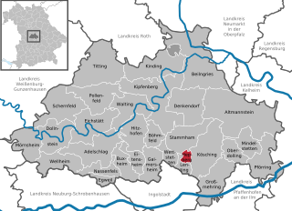
Kösching
- municipality of Germany
Hiking in Kösching
Kösching is a charming town located in Bavaria, Germany, known for its picturesque landscapes and proximity to the Danube River. While it may not be as famous for hiking as some other regions in Germany, there are still delightful trails and natural spots for outdoor enthusiasts to explore....
- Country:
- Postal Code: 85092; W-8071; W-8073; 8071; 8073
- Local Dialing Code: 08456
- Licence Plate Code: EI
- Coordinates: 48° 49' 0" N, 11° 30' 0" E
- GPS tracks (wikiloc): [Link]
- AboveSeaLevel: 390 м m
- Area: 55.60 sq km
- Population: 5335
- Web site: [Link]


Dollnstein
- municipality of Germany
Hiking in Dollnstein
Dollnstein is a charming village located in Bavaria, Germany, nestled along the banks of the Altmühl River. The area is known for its stunning landscapes, beautiful limestone cliffs, and rich history, making it an excellent destination for hiking enthusiasts. Here are some key points about hiking in Dollnstein:...
- Country:
- Postal Code: 91795
- Local Dialing Code: 08422
- Licence Plate Code: EI
- Coordinates: 48° 52' 0" N, 11° 4' 0" E
- GPS tracks (wikiloc): [Link]
- AboveSeaLevel: 395 м m
- Area: 40.55 sq km
- Population: 2342
- Web site: [Link]


Kinding
- municipality of Germany
Hiking in Kinding
Kinding, located in Bavaria, Germany, is an excellent destination for hiking enthusiasts. Its stunning landscapes, lush forests, and picturesque trails make it a favorite spot for both novice and experienced hikers. Here are some highlights and tips for hiking in Kinding:...
- Country:
- Postal Code: 85125
- Local Dialing Code: 08467
- Licence Plate Code: EI
- Coordinates: 49° 0' 0" N, 11° 22' 0" E
- GPS tracks (wikiloc): [Link]
- AboveSeaLevel: 378 м m
- Area: 51.72 sq km
- Population: 2584
- Web site: [Link]

Nassenfels
- municipality in Germany
Hiking in Nassenfels
Nassenfels is a charming village located in Bavaria, Germany, and is surrounded by beautiful natural landscapes that make it a great spot for hiking enthusiasts. Here are some key points to consider when hiking in the Nassenfels area:...
- Country:
- Postal Code: 85128
- Local Dialing Code: 08424
- Licence Plate Code: EI
- Coordinates: 48° 47' 59" N, 11° 13' 59" E
- GPS tracks (wikiloc): [Link]
- AboveSeaLevel: 400 м m
- Area: 18.46 sq km
- Population: 1285
- Web site: [Link]


Lenting
- municipality of Germany
Hiking in Lenting
Lenting, located in Bavaria, Germany, is a charming area that offers various hiking opportunities for outdoor enthusiasts. While it may not be as well-known as some larger hiking destinations in the region, it still has unique routes that showcase the beautiful Bavarian landscape....
- Country:
- Postal Code: 85101; W-8071; 8071
- Local Dialing Code: 08456
- Licence Plate Code: EI
- Coordinates: 48° 47' 59" N, 11° 28' 0" E
- GPS tracks (wikiloc): [Link]
- AboveSeaLevel: 385 м m
- Area: 8.47 sq km
- Population: 2802
- Web site: [Link]


Stammham
- municipality of Germany
Hiking in Stammham
Stammham, located in the Eichstätt district of Bavaria, Germany, is surrounded by beautiful landscapes that are perfect for hiking enthusiasts. The region features rolling hills, scenic views, and natural areas that offer a variety of trails suitable for different skill levels....
- Country:
- Postal Code: 85134; W-8071; 8071
- Local Dialing Code: 08405
- Licence Plate Code: EI
- Coordinates: 48° 51' 0" N, 11° 28' 0" E
- GPS tracks (wikiloc): [Link]
- AboveSeaLevel: 483 м m
- Area: 39.04 sq km
- Population: 1892
- Web site: [Link]

Gaimersheim
- municipality of Germany
Hiking in Gaimersheim
Gaimersheim is a small town located in Bavaria, Germany, near the city of Ingolstadt. While it may not be famous for extensive hiking trails like some of the larger national parks, there are still opportunities for hiking and enjoying the natural scenery in and around the area....
- Country:
- Postal Code: 85080; W-8071; W-8074; 8071; 8074
- Local Dialing Code: 08458
- Licence Plate Code: EI
- Coordinates: 48° 49' 0" N, 11° 22' 0" E
- GPS tracks (wikiloc): [Link]
- AboveSeaLevel: 384 м m
- Area: 28.21 sq km
- Population: 5229
- Web site: [Link]


Beilngries
- town in Bavaria, Germany
Hiking in Beilngries
Beilngries, located in Bavaria, Germany, is a charming destination for hiking enthusiasts. Nestled between the Altmühltal Nature Park and the surrounding hills, it offers a variety of scenic trails that cater to different skill levels. Here are some highlights and tips for hiking in Beilngries:...
- Country:
- Postal Code: 92339
- Local Dialing Code: 08461
- Licence Plate Code: EI
- Coordinates: 49° 2' 0" N, 11° 28' 0" E
- GPS tracks (wikiloc): [Link]
- AboveSeaLevel: 368 м m
- Area: 100.13 sq km
- Population: 9258
- Web site: [Link]


Pollenfeld
- municipality of Germany
Hiking in Pollenfeld
Pollenfeld, located in Bavaria, Germany, is surrounded by beautiful natural landscapes and offers various hiking opportunities. While not as well-known as some of the larger hiking regions in Germany, it serves as an excellent point for exploring the Franconian countryside and the nearby natural reserves....
- Country:
- Postal Code: 85131
- Local Dialing Code: 08421
- Licence Plate Code: EI
- Coordinates: 48° 57' 0" N, 11° 12' 0" E
- GPS tracks (wikiloc): [Link]
- AboveSeaLevel: 534 м m
- Area: 45.66 sq km
- Population: 2903
- Web site: [Link]

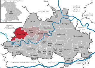
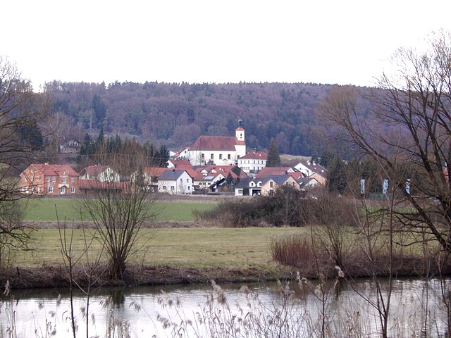
Schernfeld
- municipality of Germany
Hiking in Schernfeld
Schernfeld, located in Bavaria, Germany, is a charming area surrounded by picturesque landscapes, making it a great location for hiking enthusiasts. The region offers a combination of scenic routes that cater to various skill levels, from leisurely walks to more challenging trails....
- Country:
- Postal Code: 85132
- Local Dialing Code: 08422; 08421
- Licence Plate Code: EI
- Coordinates: 48° 54' 0" N, 11° 6' 0" E
- GPS tracks (wikiloc): [Link]
- AboveSeaLevel: 548 м m
- Area: 52.22 sq km
- Population: 3181
- Web site: [Link]

Walting
- human settlement in Germany
Hiking in Walting
Walting is a charming area in Germany, located in the state of Bavaria. It's situated near the well-known hiking destinations such as the Altmühltal Nature Park. The region offers a variety of trails ranging from easy walks to more challenging hikes, making it suitable for all levels of outdoor enthusiasts....
- Country:
- Postal Code: 85137
- Local Dialing Code: 08426
- Licence Plate Code: EI
- Coordinates: 48° 55' 0" N, 11° 18' 0" E
- GPS tracks (wikiloc): [Link]
- AboveSeaLevel: 395 м m
- Area: 39.72 sq km
- Population: 2346
- Web site: [Link]
Haunstetter Forst
- unincorporated area in Germany
Hiking in Haunstetter Forst
Haunstetter Forst is a scenic forest located near Augsburg in Bavaria, Germany. The area is known for its beautiful landscapes, diverse flora and fauna, and well-maintained hiking trails, making it a popular destination for outdoor enthusiasts....
- Country:
- Coordinates: 49° 1' 0" N, 11° 25' 0" E
- GPS tracks (wikiloc): [Link]
- AboveSeaLevel: 540 м m
- Area: 5.42 sq km
Shares border with regions:
Donau-Ries
- district in Bavaria, Germany
Hiking in Donau-Ries
Donau-Ries is a beautiful region in Bavaria, Germany, known for its stunning landscapes, rich history, and cultural significance. Spanning both the Danube River and the Ries crater, this area offers diverse hiking opportunities for both beginners and more experienced trekkers....
- Country:
- Capital: Donauwörth
- Licence Plate Code: NÖ; DON
- Coordinates: 48° 49' 48" N, 10° 40' 12" E
- GPS tracks (wikiloc): [Link]
- AboveSeaLevel: 508 м m
- Area: 1275.00 sq km
- Population: 117483
- Web site: [Link]

Neumarkt
- district of Bavaria, Germany
Hiking in Neumarkt
Neumarkt in der Oberpfalz, a district in Bavaria, Germany, is known for its picturesque landscapes and varied hiking opportunities. Set against a backdrop of rolling hills, lush forests, and charming villages, this area is ideal for both casual walkers and seasoned hikers....
- Country:
- Capital: Neumarkt in der Oberpfalz
- Licence Plate Code: PAR; NM
- Coordinates: 49° 15' 0" N, 11° 30' 0" E
- GPS tracks (wikiloc): [Link]
- AboveSeaLevel: 445 м m
- Area: 1344.00 sq km
- Population: 105346
- Web site: [Link]

Roth
- district in Bavaria, Germany
Hiking in Roth
Roth district, located in Bavaria, Germany, offers a variety of beautiful landscapes and hiking opportunities that appeal to both novice and experienced hikers. The area is characterized by rolling hills, forests, and picturesque views. Here are some highlights and tips for hiking in Roth:...
- Country:
- Capital: Roth
- Licence Plate Code: RH; HIP
- Coordinates: 49° 15' 0" N, 11° 4' 48" E
- GPS tracks (wikiloc): [Link]
- AboveSeaLevel: 355 м m
- Area: 895.00 sq km
- Population: 103944
- Web site: [Link]

Weißenburg-Gunzenhausen
- district of Bavaria, Germany
Hiking in Weißenburg-Gunzenhausen
Weißenburg-Gunzenhausen, located in Bavaria, Germany, is a great destination for hiking enthusiasts. This region is known for its beautiful landscapes, including hills, lakes, and forests, making it perfect for various outdoor activities....
- Country:
- Capital: Weißenburg in Bayern
- Licence Plate Code: WUG; GUN
- Coordinates: 49° 4' 48" N, 10° 49' 48" E
- GPS tracks (wikiloc): [Link]
- AboveSeaLevel: 452 м m
- Area: 970.83 sq km
- Population: 92331
- Web site: [Link]

Kelheim
- district in Bavaria, Germany
Hiking in Kelheim
Kelheim, located in Bavaria, Germany, is a beautiful area for hiking, characterized by its stunning landscapes, historical sites, and natural attractions. Here are some highlights you might consider when planning a hiking trip in Kelheim:...
- Country:
- Capital: Kelheim
- Licence Plate Code: ROL; RID; PAR; MAI; KEH
- Coordinates: 48° 49' 48" N, 11° 49' 48" E
- GPS tracks (wikiloc): [Link]
- AboveSeaLevel: 369 м m
- Area: 1067.00 sq km
- Population: 90040
- Web site: [Link]


Neuburg-Schrobenhausen
- district of Bavaria, Germany
Hiking in Neuburg-Schrobenhausen
Neuburg-Schrobenhausen is a picturesque district in Bavaria, Germany, offering a mix of beautiful landscapes, rich history, and outdoor activities. When it comes to hiking in this area, there are several trails and natural attractions to explore. Here’s what you should know:...
- Country:
- Capital: Neuburg an der Donau
- Licence Plate Code: SOB; ND
- Coordinates: 48° 40' 12" N, 11° 10' 12" E
- GPS tracks (wikiloc): [Link]
- AboveSeaLevel: 378 м m
- Area: 740.00 sq km
- Population: 76493
- Web site: [Link]

Pfaffenhofen
- district of Bavaria, Germany
Hiking in Pfaffenhofen
Pfaffenhofen is a district in Bavaria, Germany, known for its picturesque landscapes and outdoor recreational opportunities, including hiking. The region features a mix of rolling hills, forests, rivers, and farmland, providing a variety of scenic routes for hikers of all skill levels....
- Country:
- Capital: Pfaffenhofen an der Ilm
- Licence Plate Code: PAF
- Coordinates: 48° 30' 0" N, 11° 30' 0" E
- GPS tracks (wikiloc): [Link]
- AboveSeaLevel: 439 м m
- Area: 760.00 sq km
- Population: 126244
- Web site: [Link]

Ingolstadt
- town in Bavaria, Germany
Hiking in Ingolstadt
Hiking in and around Ingolstadt, a city located in Bavaria, Germany, offers a variety of scenic routes and natural landscapes to explore. While Ingolstadt itself is more urban, it’s conveniently situated near several natural attractions and parks. Here are some key points to consider when hiking in this region:...
- Country:
- Postal Code: 85055; 85053; 85051; 85057; 85049
- Local Dialing Code: 08459; 08458; 08450; 0841; 08424
- Licence Plate Code: IN
- Coordinates: 48° 45' 49" N, 11° 25' 34" E
- GPS tracks (wikiloc): [Link]
- AboveSeaLevel: 368 м m
- Area: 133.35 sq km
- Population: 137072
- Web site: [Link]

Weißenburg in Bayern
- town in Bavaria, Germany
Hiking in Weißenburg in Bayern
Weißenburg in Bayern, located in the picturesque region of Bavaria, Germany, offers a wonderful variety of hiking opportunities for outdoor enthusiasts. Here are some key points about hiking in this area:...
- Country:
- Postal Code: 91781
- Local Dialing Code: 09141
- Licence Plate Code: WUG
- Coordinates: 49° 1' 50" N, 10° 58' 19" E
- GPS tracks (wikiloc): [Link]
- AboveSeaLevel: 422 м m
- Area: 97.55 sq km
- Population: 17976
- Web site: [Link]


Nennslingen
- human settlement in Germany
Hiking in Nennslingen
Nennslingen is a small picturesque village in Bavaria, Germany, surrounded by beautiful nature that offers great hiking opportunities. The region is characterized by its rolling hills, lush forests, and well-marked trails that cater to various skill levels....
- Country:
- Postal Code: 91790
- Local Dialing Code: 09147
- Licence Plate Code: WUG
- Coordinates: 49° 3' 0" N, 11° 8' 0" E
- GPS tracks (wikiloc): [Link]
- AboveSeaLevel: 523 м m
- Area: 21.97 sq km
- Population: 1385
- Web site: [Link]


Solnhofen
- municipality of Germany
Hiking in Solnhofen
Solnhofen is a small town located in Bavaria, Germany, known primarily for its stunning natural landscapes and historical significance, particularly regarding the famous Solnhofen limestone that has preserved many Jurassic fossils. Hiking in and around Solnhofen offers an array of beautiful routes, fascinating geological features, and pleasant scenery....
- Country:
- Postal Code: 91807
- Local Dialing Code: 09145
- Licence Plate Code: WUG
- Coordinates: 48° 53' 0" N, 11° 0' 0" E
- GPS tracks (wikiloc): [Link]
- AboveSeaLevel: 408 м m
- Area: 13.5 sq km
- Population: 1740
- Web site: [Link]