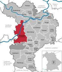
Pförring (Pförring)
- municipality in Bavaria, Germany
Pförring, located in Bavaria, Germany, is a quaint town surrounded by scenic landscapes that can be appealing for hikers. While there may not be extensive hiking trails specifically in Pförring itself, the surrounding areas offer beautiful countryside and potential routes for outdoor enthusiasts.
Hiking Opportunities:
-
Nature Trails: Explore local nature trails that may take you through fields, forests, and along rivers. These trails provide opportunities to experience the natural beauty of the Bavarian landscape.
-
Nearby Parks and Reserves: Look for nearby nature parks or reserves that might have designated hiking paths. These areas typically offer marked trails that cater to various skill levels.
-
Local Recommendations: Engage with local hiking groups or visitor centers for maps and recommendations on hidden gems or well-established trails in the region.
-
Adjacent Towns: Consider visiting nearby towns or cities, such as Ingolstadt or Regensburg, which may offer more extensive hiking and walking options, including scenic routes by rivers or through historical sites.
Tips for Hiking in Pförring:
- Weather Awareness: Always check the weather before heading out, as conditions can change rapidly.
- Gear Up: Wear appropriate hiking footwear and pack essentials such as water, snacks, a map, and a first-aid kit.
- Respect Nature: Stick to marked trails, avoid disturbing wildlife, and follow Leave No Trace principles.
Hiking in and around Pförring can offer a peaceful retreat into nature, with plenty of opportunities to explore the beautiful Bavarian countryside. Always ensure to have adequate information and preparation before starting your adventure!
- Country:

- Postal Code: 85104; W-8071; 8071
- Local Dialing Code: 08403
- Licence Plate Code: EI
- Coordinates: 48° 48' 30" N, 11° 41' 24" E


- GPS tracks (wikiloc): [Link]
- AboveSeaLevel: 356 м m
- Area: 43.54 sq km
- Population: 2881
- Web site: http://www.pfoerring.de
- Wikipedia en: wiki(en)
- Wikipedia: wiki(de)
- Wikidata storage: Wikidata: Q505785
- Wikipedia Commons Category: [Link]
- Freebase ID: [/m/02q1gjy]
- GeoNames ID: Alt: [2853974]
- VIAF ID: Alt: [234133628]
- OSM relation ID: [943544]
- GND ID: Alt: [4045634-1]
- archINFORM location ID: [14007]
- TGN ID: [7119571]
- Historical Gazetteer (GOV) ID: [object_300585]
- Bavarikon ID: [ODB_A00001033]
- German municipality key: 09176153
- LAU: 09176153
Shares border with regions:


Vohburg an der Donau
- town in Bavaria, Germany
 Hiking in Vohburg an der Donau
Vohburg, located in Bavaria, Germany, offers a variety of hiking opportunities that can appeal to both casual walkers and more serious hikers. Here are some highlights and tips for hiking in and around Vohburg:...
- Country:

- Postal Code: 85088
- Local Dialing Code: 08457
- Licence Plate Code: PAF
- Coordinates: 48° 46' 11" N, 11° 37' 6" E


- GPS tracks (wikiloc): [Link]
- AboveSeaLevel: 371 м m
- Area: 45.19 sq km
- Population: 5863
- Web site: [Link]


Oberdolling
- municipality of Germany
Oberdolling is a picturesque village in Bavaria, Germany, surrounded by lush landscapes, making it an excellent location for hiking enthusiasts. While it may not be as widely known as some other hiking destinations in the region, there are still several trails and opportunities to explore the natural beauty of the area....
- Country:

- Postal Code: 85129; W-8071; 8071
- Local Dialing Code: 08404
- Licence Plate Code: EI
- Coordinates: 48° 50' 0" N, 11° 35' 0" E


- GPS tracks (wikiloc): [Link]
- AboveSeaLevel: 382 м m
- Area: 19.36 sq km
- Population: 826
- Web site: [Link]


Neustadt an der Donau
- municipality of Germany
 Hiking in Neustadt an der Donau
Neustadt an der Donau, located in Bavaria, Germany, is a charming area that offers a variety of hiking opportunities, thanks to its scenic landscapes, historic sites, and proximity to the Danube River. Here's what you should know when planning your hiking adventures in and around Neustadt an der Donau:...
- Country:

- Postal Code: 93333
- Local Dialing Code: 09445
- Licence Plate Code: KEH
- Coordinates: 48° 48' 25" N, 11° 46' 10" E


- GPS tracks (wikiloc): [Link]
- AboveSeaLevel: 357 м m
- Area: 93.55 sq km
- Population: 9811
- Web site: [Link]

Münchsmünster
- municipality of Germany
Münchsmünster, located in Bavaria, Germany, offers a peaceful escape for hiking enthusiasts looking for serene landscapes and a touch of nature. The area is characterized by its picturesque countryside, rolling hills, and lush forests, making it an excellent destination for both novice and experienced hikers....
- Country:

- Postal Code: 85126
- Local Dialing Code: 08402
- Licence Plate Code: PAF
- Coordinates: 48° 45' 51" N, 11° 41' 28" E


- GPS tracks (wikiloc): [Link]
- AboveSeaLevel: 357 м m
- Area: 16.21 sq km
- Population: 2922
- Web site: [Link]

Altmannstein
- municipality of Germany
Altmannstein, located in Bavaria, Germany, is a wonderful destination for hiking enthusiasts. Nestled in the picturesque landscape of the Danube Valley, this area offers a variety of trails suitable for different skill levels. Here are some key points about hiking in Altmannstein:...
- Country:

- Postal Code: 93336
- Local Dialing Code: 09446; 08468
- Licence Plate Code: EI
- Coordinates: 48° 54' 0" N, 11° 39' 0" E


- GPS tracks (wikiloc): [Link]
- AboveSeaLevel: 388 м m
- Area: 114.29 sq km
- Population: 5892
- Web site: [Link]


Mindelstetten
- municipality of Germany
Mindelstetten is a small town located in Bavaria, Germany, known for its picturesque landscapes and proximity to nature. While it may not be a major hiking destination compared to larger national parks, there are still opportunities for enjoyable hikes in and around the area....
- Country:

- Postal Code: 93349
- Local Dialing Code: 08404
- Licence Plate Code: EI
- Coordinates: 48° 51' 0" N, 11° 39' 0" E


- GPS tracks (wikiloc): [Link]
- AboveSeaLevel: 403 м m
- Area: 22.72 sq km
- Population: 1273
- Web site: [Link]
