
Amboise (Amboise)

- commune in Indre-et-Loire, France
- Country:

- Postal Code: 37530
- Coordinates: 47° 24' 41" N, 0° 58' 57" E


- GPS tracks (wikiloc): [Link]
- Area: 40.65 sq km
- Population: 13119
- Web site: http://www.ville-amboise.fr
- Wikipedia en: wiki(en)
- Wikipedia: wiki(fr)
- Wikidata storage: Wikidata: Q205116
- Wikipedia Commons Gallery: [Link]
- Wikipedia Commons Category: [Link]
- Wikipedia Commons Maps Category: [Link]
- Freebase ID: [/m/01jvvc]
- GeoNames ID: Alt: [3037902]
- SIREN number: [213700032]
- BnF ID: [15257555k]
- VIAF ID: Alt: [129650678]
- OSM relation ID: [80302]
- GND ID: Alt: [4079744-2]
- archINFORM location ID: [6716]
- Library of Congress authority ID: Alt: [no97064896]
- PACTOLS thesaurus ID: [pcrtSAew6ByD4a]
- MusicBrainz area ID: [392f4db7-9ef8-403c-9f5a-74e2d96d1a5f]
- Quora topic ID: [Amboise]
- Encyclopædia Britannica Online ID: [place/Amboise-France]
- Gran Enciclopèdia Catalana ID: [0003389]
- Great Russian Encyclopedia Online ID: [1817390]
- Digital Atlas of the Roman Empire ID: [4018]
- YouTube channel ID: [UCJRebZIVhbuM0-JYeGmhUFg]
- INSEE municipality code: 37003
Shares border with regions:


La Croix-en-Touraine
- commune in Indre-et-Loire, France
- Country:
- Postal Code: 37150
- Coordinates: 47° 20' 12" N, 0° 59' 26" E
- GPS tracks (wikiloc): [Link]
- Area: 15.04 sq km
- Population: 2177


Civray-de-Touraine
- commune in Indre-et-Loire, France
- Country:
- Postal Code: 37150
- Coordinates: 47° 19' 56" N, 1° 2' 55" E
- GPS tracks (wikiloc): [Link]
- Area: 22.88 sq km
- Population: 1845
- Web site: [Link]


Dierre
- commune in Indre-et-Loire, France
- Country:
- Postal Code: 37150
- Coordinates: 47° 20' 46" N, 0° 57' 9" E
- GPS tracks (wikiloc): [Link]
- Area: 10.27 sq km
- Population: 595
- Web site: [Link]

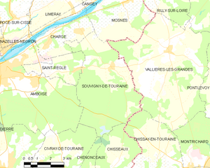
Souvigny-de-Touraine
- commune in Indre-et-Loire, France
- Country:
- Postal Code: 37530
- Coordinates: 47° 24' 41" N, 1° 5' 22" E
- GPS tracks (wikiloc): [Link]
- Area: 26.18 sq km
- Population: 386


Pocé-sur-Cisse
- commune in Indre-et-Loire, France
- Country:
- Postal Code: 37530
- Coordinates: 47° 26' 40" N, 0° 59' 27" E
- GPS tracks (wikiloc): [Link]
- Area: 10.61 sq km
- Population: 1625
- Web site: [Link]


Saint-Martin-le-Beau
- commune in Indre-et-Loire, France
- Country:
- Postal Code: 37270
- Coordinates: 47° 21' 21" N, 0° 54' 35" E
- GPS tracks (wikiloc): [Link]
- Area: 18.44 sq km
- Population: 3165
- Web site: [Link]
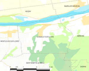
Lussault-sur-Loire
- commune in Indre-et-Loire, France
- Country:
- Postal Code: 37400
- Coordinates: 47° 23' 48" N, 0° 55' 6" E
- GPS tracks (wikiloc): [Link]
- Area: 9.36 sq km
- Population: 750


Saint-Règle
- commune in Indre-et-Loire, France
- Country:
- Postal Code: 37530
- Coordinates: 47° 24' 30" N, 1° 3' 12" E
- GPS tracks (wikiloc): [Link]
- Area: 6.49 sq km
- Population: 558


Chargé
- commune in Indre-et-Loire, France
- Country:
- Postal Code: 37530
- Coordinates: 47° 25' 57" N, 1° 1' 50" E
- GPS tracks (wikiloc): [Link]
- Area: 8.46 sq km
- Population: 1293
- Web site: [Link]


Nazelles-Négron
- commune in Indre-et-Loire, France
- Country:
- Postal Code: 37530
- Coordinates: 47° 25' 56" N, 0° 57' 12" E
- GPS tracks (wikiloc): [Link]
- AboveSeaLevel: 51 м m
- Area: 22.32 sq km
- Population: 3631
- Web site: [Link]