canton of Amboise (canton d'Amboise)

- canton of France
- Country:

- Capital: Amboise
- Coordinates: 47° 26' 15" N, 1° 0' 48" E


- GPS tracks (wikiloc): [Link]
- Population: 28315
- Wikipedia en: wiki(en)
- Wikipedia: wiki(fr)
- Wikidata storage: Wikidata: Q1276841
- INSEE canton code: [3701]
Includes regions:


Cangey
- commune in Indre-et-Loire, France
- Country:
- Postal Code: 37530
- Coordinates: 47° 28' 4" N, 1° 3' 37" E
- GPS tracks (wikiloc): [Link]
- Area: 22.98 sq km
- Population: 1068
- Web site: [Link]

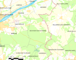
Souvigny-de-Touraine
- commune in Indre-et-Loire, France
- Country:
- Postal Code: 37530
- Coordinates: 47° 24' 41" N, 1° 5' 22" E
- GPS tracks (wikiloc): [Link]
- Area: 26.18 sq km
- Population: 386

Montreuil-en-Touraine
- commune in Indre-et-Loire, France
- Country:
- Postal Code: 37530
- Coordinates: 47° 29' 13" N, 0° 56' 49" E
- GPS tracks (wikiloc): [Link]
- Area: 25.09 sq km
- Population: 836
- Web site: [Link]


Pocé-sur-Cisse
- commune in Indre-et-Loire, France
- Country:
- Postal Code: 37530
- Coordinates: 47° 26' 40" N, 0° 59' 27" E
- GPS tracks (wikiloc): [Link]
- Area: 10.61 sq km
- Population: 1625
- Web site: [Link]


Mosnes
- commune in Indre-et-Loire, France
- Country:
- Postal Code: 37530
- Coordinates: 47° 27' 20" N, 1° 6' 3" E
- GPS tracks (wikiloc): [Link]
- Area: 14.5 sq km
- Population: 787


Limeray
- commune in Indre-et-Loire, France
- Country:
- Postal Code: 37530
- Coordinates: 47° 27' 34" N, 1° 2' 29" E
- GPS tracks (wikiloc): [Link]
- Area: 14.39 sq km
- Population: 1280
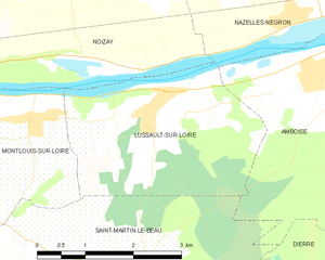
Lussault-sur-Loire
- commune in Indre-et-Loire, France
- Country:
- Postal Code: 37400
- Coordinates: 47° 23' 48" N, 0° 55' 6" E
- GPS tracks (wikiloc): [Link]
- Area: 9.36 sq km
- Population: 750


Amboise
- commune in Indre-et-Loire, France
- Country:
- Postal Code: 37530
- Coordinates: 47° 24' 41" N, 0° 58' 57" E
- GPS tracks (wikiloc): [Link]
- Area: 40.65 sq km
- Population: 13119
- Web site: [Link]


Saint-Ouen-les-Vignes
- commune in Indre-et-Loire, France
- Country:
- Postal Code: 37530
- Coordinates: 47° 28' 11" N, 0° 59' 40" E
- GPS tracks (wikiloc): [Link]
- Area: 18.55 sq km
- Population: 1016


Saint-Règle
- commune in Indre-et-Loire, France
- Country:
- Postal Code: 37530
- Coordinates: 47° 24' 30" N, 1° 3' 12" E
- GPS tracks (wikiloc): [Link]
- Area: 6.49 sq km
- Population: 558


Chargé
- commune in Indre-et-Loire, France
- Country:
- Postal Code: 37530
- Coordinates: 47° 25' 57" N, 1° 1' 50" E
- GPS tracks (wikiloc): [Link]
- Area: 8.46 sq km
- Population: 1293
- Web site: [Link]


Nazelles-Négron
- commune in Indre-et-Loire, France
- Country:
- Postal Code: 37530
- Coordinates: 47° 25' 56" N, 0° 57' 12" E
- GPS tracks (wikiloc): [Link]
- AboveSeaLevel: 51 м m
- Area: 22.32 sq km
- Population: 3631
- Web site: [Link]