Antoingt (Antoingt)

- commune in Puy-de-Dôme, France
- Country:

- Postal Code: 63340
- Coordinates: 45° 29' 45" N, 3° 10' 44" E


- GPS tracks (wikiloc): [Link]
- Area: 7.83 sq km
- Population: 386
- Wikipedia en: wiki(en)
- Wikipedia: wiki(fr)
- Wikidata storage: Wikidata: Q266988
- Wikipedia Commons Category: [Link]
- Freebase ID: [/m/03qh7bm]
- GeoNames ID: Alt: [6452447]
- SIREN number: [216300053]
- BnF ID: [15269355q]
- INSEE municipality code: 63005
Shares border with regions:


Bergonne
- commune in Puy-de-Dôme, France
- Country:
- Postal Code: 63500
- Coordinates: 45° 30' 21" N, 3° 13' 13" E
- GPS tracks (wikiloc): [Link]
- Area: 5.75 sq km
- Population: 349


Gignat
- commune in Puy-de-Dôme, France
- Country:
- Postal Code: 63340
- Coordinates: 45° 28' 48" N, 3° 13' 13" E
- GPS tracks (wikiloc): [Link]
- Area: 3.49 sq km
- Population: 242
Solignat
- commune in Puy-de-Dôme, France
- Country:
- Postal Code: 63500
- Coordinates: 45° 30' 56" N, 3° 10' 19" E
- GPS tracks (wikiloc): [Link]
- Area: 11.07 sq km
- Population: 487


Mareugheol
- commune in Puy-de-Dôme, France
- Country:
- Postal Code: 63340
- Coordinates: 45° 29' 17" N, 3° 9' 55" E
- GPS tracks (wikiloc): [Link]
- Area: 7.54 sq km
- Population: 190

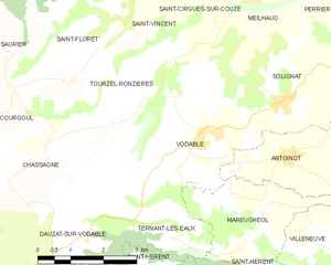
Vodable
- commune in Puy-de-Dôme, France
- Country:
- Postal Code: 63500
- Coordinates: 45° 30' 28" N, 3° 8' 48" E
- GPS tracks (wikiloc): [Link]
- Area: 11.68 sq km
- Population: 199
- Web site: [Link]