Antrona Schieranco (Antrona Schieranco)
- Italian comune
 Hiking in Antrona Schieranco
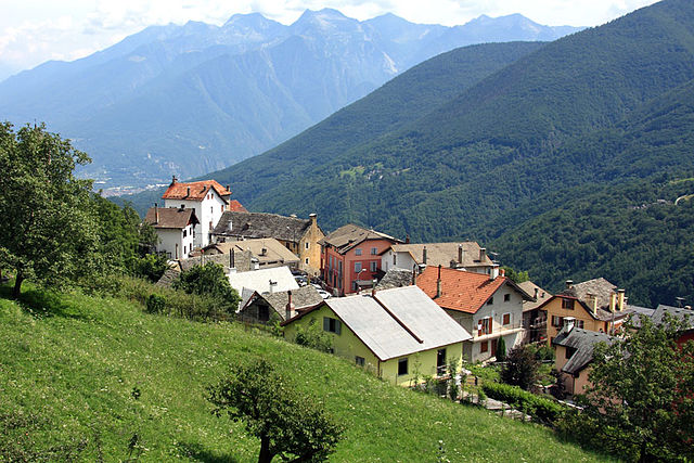
Antrona Schieranco is a beautiful area located in the Ossola Valley in the Piedmont region of northern Italy. It’s known for its stunning natural landscapes, featuring mountains, valleys, waterfalls, and lakes, making it a fantastic destination for hiking enthusiasts. Here are some highlights and tips for hiking in Antrona Schieranco:
Trails and Routes
-
Antrona Valley Trails: There are numerous trails catering to various skill levels. You can find easy walks, moderate hikes, and challenging routes. Many trails offer breathtaking views of the surrounding mountains and forests.
-
Lake Antrona: A popular destination is Lake Antrona, where you can enjoy a scenic hike around the lake’s perimeter or take a more challenging route up into the surrounding hills for panoramic views.
-
Val Grande National Park: Just a short distance away, this park offers more advanced hikes for experienced hikers. The rugged terrain is ideal for those seeking solitude and wilderness.
-
Cascate di Pomeretto: A beautiful hike leads to the Pomeretto waterfalls, where you can enjoy the sound of cascading water surrounded by lush vegetation.
Tips for Hiking
-
Preparation: Always check the weather conditions before setting out. The weather can change rapidly in the mountains.
-
Footwear: Wear appropriate hiking boots with good grip and ankle support, as some trails can be rocky and uneven.
-
Navigation: Bring a map or use a hiking app to help navigate the trails. While many paths are well-marked, having a backup is crucial.
-
Hydration and Snacks: Carry enough water and snacks to keep your energy up during the hike.
-
Wildlife: Be aware that you may encounter wildlife. Respect their habitat and keep a safe distance.
Best Time to Visit
The ideal time for hiking in Antrona Schieranco is during late spring to early autumn (May to October). The weather is generally milder, and the trails are more accessible. However, certain high-altitude routes may still have snow early in the season.
Cultural Aspects
Antrona Schieranco is also rich in cultural heritage. Don’t miss the opportunity to explore local villages, traditional architecture, and perhaps sample some regional cuisine after your hike.
Conclusion
Hiking in Antrona Schieranco offers a serene experience in nature, coupled with stunning scenery and opportunities for adventure. Whether you're an avid hiker or a casual walker, this area has something to offer everyone. Always prioritize safety, and respect the natural environment while enjoying your hikes!
- Country:

- Postal Code: 28030
- Local Dialing Code: 0324
- Licence Plate Code: VB
- Coordinates: 46° 4' 0" N, 8° 7' 0" E


- GPS tracks (wikiloc): [Link]
- AboveSeaLevel: 902 м m
- Area: 100.18 sq km
- Population: 426
- Web site: http://www.comune.antronaschieranco.vb.it/
- Wikipedia en: wiki(en)
- Wikipedia: wiki(it)
- Wikidata storage: Wikidata: Q23205
- Wikipedia Commons Category: [Link]
- Freebase ID: [/m/0gr7pw]
- GeoNames ID: Alt: [6542825]
- VIAF ID: Alt: [167749132]
- OSM relation ID: [46711]
- ISTAT ID: 103001
- Italian cadastre code: A317
Shares border with regions:
Bognanco
- Italian comune
Hiking in Bognanco
Bognanco is a charming village located in the Ossola Valley in the Piedmont region of Italy, known for its beautiful natural landscapes and rich cultural heritage. Hiking in and around Bognanco can be a wonderful experience, thanks to its scenic trails, lush forests, and stunning mountain views....
- Country:
- Postal Code: 28042
- Local Dialing Code: 0324
- Licence Plate Code: VB
- Coordinates: 46° 7' 34" N, 8° 12' 0" E
- GPS tracks (wikiloc): [Link]
- AboveSeaLevel: 980 м m
- Area: 58 sq km
- Population: 200
- Web site: [Link]

Calasca-Castiglione
- Italian comune
Hiking in Calasca-Castiglione
Calasca-Castiglione is a picturesque municipality located in the Ossola Valley in the Piedmont region of Italy, surrounded by stunning alpine scenery. Hiking in this area offers a unique blend of natural beauty, cultural heritage, and diverse trails suitable for various skill levels. Here’s what you need to know about hiking in Calasca-Castiglione:...
- Country:
- Postal Code: 28873
- Local Dialing Code: 0324
- Licence Plate Code: VB
- Coordinates: 46° 0' 12" N, 8° 10' 9" E
- GPS tracks (wikiloc): [Link]
- AboveSeaLevel: 665 м m
- Area: 57.07 sq km
- Population: 625
- Web site: [Link]
Ceppo Morelli
- Italian comune
Hiking in Ceppo Morelli
Ceppo Morelli is a charming destination for hiking enthusiasts located in the province of Verbano-Cusio-Ossola in the Piedmont region of northern Italy. Nestled in the foothills of the Alps, this area is known for its stunning natural landscapes, lush forests, and scenic views....
- Country:
- Postal Code: 28875
- Local Dialing Code: 0324
- Licence Plate Code: VB
- Coordinates: 45° 58' 0" N, 8° 4' 0" E
- GPS tracks (wikiloc): [Link]
- AboveSeaLevel: 793 м m
- Area: 40.19 sq km
- Population: 302
- Web site: [Link]
Montescheno
- Italian comune
Hiking in Montescheno
Montescheno is a picturesque village located in the Piedmont region of northern Italy, nestled in the Ossola Valley. The area is known for its stunning landscapes, rich biodiversity, and charming old-world architecture, making it a great destination for hiking enthusiasts....
- Country:
- Postal Code: 28843
- Local Dialing Code: 0324
- Licence Plate Code: VB
- Coordinates: 46° 4' 0" N, 8° 14' 0" E
- GPS tracks (wikiloc): [Link]
- AboveSeaLevel: 512 м m
- Area: 22.17 sq km
- Population: 398
- Web site: [Link]
Vanzone con San Carlo
- Italian comune
Hiking in Vanzone con San Carlo
Vanzone con San Carlo is a charming mountain village located in the Ossola Valley in the Piedmont region of northern Italy. This area is known for its stunning natural beauty, characterized by towering peaks, lush forests, and scenic trails that attract hiking enthusiasts from all over....
- Country:
- Postal Code: 28879
- Local Dialing Code: 0324
- Licence Plate Code: VB
- Coordinates: 45° 59' 17" N, 8° 7' 53" E
- GPS tracks (wikiloc): [Link]
- AboveSeaLevel: 677 м m
- Area: 15.73 sq km
- Population: 386
- Web site: [Link]


Saas-Almagell
- municipality in Switzerland
Hiking in Saas-Almagell
Saas-Almagell is a picturesque village in the Swiss Alps, situated in the Valais region, and is part of the larger Saas Valley. It's known for its stunning landscapes, diverse hiking trails, and a wide range of outdoor activities. Here are some key highlights and tips for hiking in Saas-Almagell:...
- Country:

- Postal Code: 3905
- Local Dialing Code: 027
- Licence Plate Code: VS
- Coordinates: 46° 5' 40" N, 7° 57' 26" E
- GPS tracks (wikiloc): [Link]
- AboveSeaLevel: 1672 м m
- Area: 110.28 sq km
- Population: 377
- Web site: [Link]


Zwischbergen
- municipality in Switzerland
Hiking in Zwischbergen
Zwischbergen, located in the Swiss Alps near the village of Simplon in the Valais region, is known for its stunning landscapes and excellent hiking opportunities. Here are some key highlights about hiking in Zwischbergen:...
- Country:
- Postal Code: 3901
- Licence Plate Code: VS
- Coordinates: 46° 10' 0" N, 8° 7' 0" E
- GPS tracks (wikiloc): [Link]
- AboveSeaLevel: 1322 м m
- Area: 86.1 sq km
- Population: 77
- Web site: [Link]