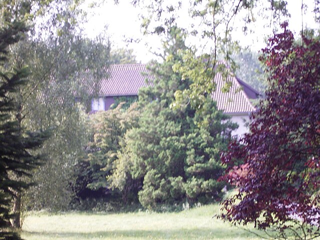
Apensen (Apensen)

- municipality of Germany
 Hiking in Apensen
Apensen, a small town in Lower Saxony, Germany, offers a charming hiking experience characterized by its serene landscapes and natural beauty. While it may not be as well-known as larger national parks, there are several aspects to consider when hiking in and around Apensen:
-
Trails and Routes: The area around Apensen has a network of walking and hiking trails that are suitable for different levels of hikers. You can expect a mix of forest paths, open fields, and farmland, providing a glimpse into the local rural landscape.
-
Scenic Views: The countryside around Apensen features picturesque views, especially during spring and summer when the fields are green, and wildflowers bloom. The flat terrain makes it accessible for families and casual hikers.
-
Access to Nature: Being in Lower Saxony, the region is known for its natural reserves and forests. Nearby areas offer opportunities to immerse yourself in nature, birdwatch, and even encounter local wildlife.
-
Local Culture: Keep an eye out for traditional farms and charming villages along your path. Experiencing the local culture and community can enhance your hiking experience.
-
Safety and Preparedness: Always check the weather before heading out, wear appropriate footwear, and carry enough water and snacks. Ensure that you have a map or GPS device as some trails may not be well-marked.
-
Seasonal Considerations: The best times for hiking in Apensen are during the spring and fall when temperatures are mild, and the landscapes are particularly beautiful.
If you’re considering a hiking trip to Apensen, you might also want to explore nearby towns or natural parks for additional hiking opportunities. Happy hiking!
- Country:

- Postal Code: 21641
- Local Dialing Code: 04167; 04163
- Licence Plate Code: STD
- Coordinates: 53° 26' 9" N, 9° 36' 56" E


- GPS tracks (wikiloc): [Link]
- AboveSeaLevel: 29 м m
- Area: 20.74 sq km
- Population: 4225
- Web site: http://www.apensen.de/
- Wikipedia en: wiki(en)
- Wikipedia: wiki(de)
- Wikidata storage: Wikidata: Q503857
- Wikipedia Commons Category: [Link]
- Freebase ID: [/m/06h6_j]
- Freebase ID: [/m/06h6_j]
- Freebase ID: [/m/06h6_j]
- GeoNames ID: Alt: [2955815]
- GeoNames ID: Alt: [2955815]
- GeoNames ID: Alt: [2955815]
- VIAF ID: Alt: [151288059]
- VIAF ID: Alt: [151288059]
- VIAF ID: Alt: [151288059]
- OSM relation ID: [446434]
- OSM relation ID: [446434]
- OSM relation ID: [446434]
- GND ID: Alt: [4389930-4]
- GND ID: Alt: [4389930-4]
- GND ID: Alt: [4389930-4]
- Library of Congress authority ID: Alt: [n82023255]
- Library of Congress authority ID: Alt: [n82023255]
- Library of Congress authority ID: Alt: [n82023255]
- WOEID: [635309]
- WOEID: [635309]
- WOEID: [635309]
- German municipality key: 03359003
- German municipality key: 03359003
- German municipality key: 03359003
Shares border with regions:


Buxtehude
- German town
Hiking in Buxtehude
Buxtehude, located in Lower Saxony, Germany, is known for its beautiful landscapes and charming surroundings, making it a great destination for hiking enthusiasts. The area is characterized by its lush woodlands, scenic rivers, and picturesque countryside....
- Country:
- Postal Code: 21614
- Local Dialing Code: 04161
- Licence Plate Code: STD
- Coordinates: 53° 28' 37" N, 9° 42' 4" E
- GPS tracks (wikiloc): [Link]
- AboveSeaLevel: 5 м m
- Area: 76.49 sq km
- Population: 40033
- Web site: [Link]

Sauensiek
- municipality of Germany
Hiking in Sauensiek
Sauensiek is a small village located in Lower Saxony, Germany, and offers some picturesque landscapes for hiking enthusiasts. While it may not be as widely known as some other hiking destinations, it provides a charming experience for those looking to explore the natural beauty of the area. Here are some aspects to consider when planning a hiking trip to Sauensiek:...
- Country:
- Postal Code: 21644
- Local Dialing Code: 04169
- Licence Plate Code: STD
- Coordinates: 53° 23' 0" N, 9° 36' 0" E
- GPS tracks (wikiloc): [Link]
- AboveSeaLevel: 39 м m
- Area: 31.37 sq km
- Population: 2468
- Web site: [Link]


Beckdorf
- municipality of Germany
Hiking in Beckdorf
Beckdorf, located in Lower Saxony, Germany, is not one of the most well-known hiking destinations but offers a quaint experience for those looking to explore nature in a more serene setting. Here are some aspects to consider if you’re planning to hike in or around Beckdorf:...
- Country:
- Postal Code: 21643
- Local Dialing Code: 04167
- Licence Plate Code: STD
- Coordinates: 53° 24' 47" N, 9° 36' 38" E
- GPS tracks (wikiloc): [Link]
- AboveSeaLevel: 40 м m
- Area: 21.98 sq km
- Population: 2679
- Web site: [Link]

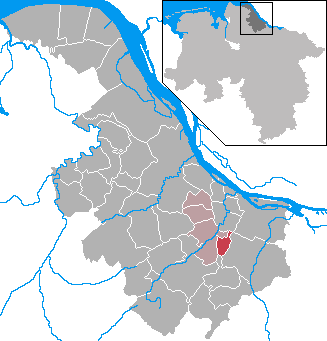
Nottensdorf
- municipality of Germany
Hiking in Nottensdorf
Nottensdorf, located in the northern part of Germany, offers some lovely hiking opportunities in a scenic environment. The region is characterized by a mix of forests, meadows, and waterways, providing a diverse landscape for hikers of all skill levels....
- Country:
- Postal Code: 21640
- Local Dialing Code: 04163
- Licence Plate Code: STD
- Coordinates: 53° 29' 0" N, 9° 36' 0" E
- GPS tracks (wikiloc): [Link]
- AboveSeaLevel: 22 м m
- Area: 7.14 sq km
- Population: 1441
- Web site: [Link]