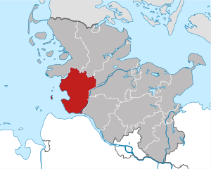
Stade (Landkreis Stade)

- German district of Lower Saxony
 Hiking in Stade
Stade, located in Lower Saxony, Germany, offers a range of hiking opportunities that allow you to explore its picturesque natural landscapes, historical sites, and charming small towns. Here are some highlights for hiking in the Stade district:
Scenic Areas
-
Nature Reserves: The area is home to various nature reserves where visitors can hike through diverse ecosystems, including wetlands and forested areas. The Gieselau and Altes Land regions are particularly scenic.
-
Elbe River Trails: The Elbe River runs near Stade, offering stunning riverside trails. You can enjoy leisurely hikes along the riverbanks with views of the water and wildlife.
-
Lower Saxon Wadden Sea National Park: A bit further away, this UNESCO World Heritage site provides unique hiking experiences along the coast and tidal flats. You can explore the diverse flora and fauna while enjoying the coastal scenery.
Hiking Trails
-
Local Trails: There are many marked hiking trails in and around Stade, suitable for all skill levels. Some trails lead through forests, fields, and along the river, showcasing the region's natural beauty.
-
Cycle Routes: While primarily for cycling, many of these routes are also accessible for hiking, providing a chance to explore more extensive areas around Stade.
Attractions Along the Way
- Historical Towns: Stade itself is a historical town with beautiful half-timbered houses and a charming old town. You can plan a hike that includes a visit to these sites.
- Cultural Landmarks: Look for trails that guide you past cultural landmarks, including churches and historical buildings.
Tips for Hiking in Stade
- Check Weather Conditions: Be prepared for changing weather, especially in the transitional seasons.
- Use Local Maps: Obtain local hiking maps or apps for the best routes and to make sure trails are open and accessible.
- Safety: As with any outdoor activity, let someone know your plans and expected return time.
Conclusion
Hiking in Stade offers a mix of natural beauty, cultural experiences, and relaxing trails. Whether you’re an experienced hiker or just looking for a pleasant walk in nature, Stade provides diverse options to enjoy the outdoors.
- Country:

- Licence Plate Code: STD
- Coordinates: 53° 34' 48" N, 9° 25' 12" E


- GPS tracks (wikiloc): [Link]
- AboveSeaLevel: 1 м m
- Area: 1266.00 sq km
- Population: 201638
- Web site: http://www.landkreis-stade.de
- Wikipedia en: wiki(en)
- Wikipedia: wiki(de)
- Wikidata storage: Wikidata: Q5906
- Wikipedia Commons Category: [Link]
- Wikipedia Commons Maps Category: [Link]
- Freebase ID: [/m/012wqx]
- Freebase ID: [/m/012wqx]
- Freebase ID: [/m/012wqx]
- GeoNames ID: Alt: [3221046]
- GeoNames ID: Alt: [3221046]
- GeoNames ID: Alt: [3221046]
- VIAF ID: Alt: [134343512]
- VIAF ID: Alt: [134343512]
- VIAF ID: Alt: [134343512]
- OSM relation ID: [451362]
- OSM relation ID: [451362]
- OSM relation ID: [451362]
- GND ID: Alt: [4056712-6]
- GND ID: Alt: [4056712-6]
- GND ID: Alt: [4056712-6]
- archINFORM location ID: [11064]
- archINFORM location ID: [11064]
- archINFORM location ID: [11064]
- Library of Congress authority ID: Alt: [n80104770]
- Library of Congress authority ID: Alt: [n80104770]
- Library of Congress authority ID: Alt: [n80104770]
- Quora topic ID: [Stade]
- Quora topic ID: [Stade]
- Quora topic ID: [Stade]
- TGN ID: [7076850]
- TGN ID: [7076850]
- TGN ID: [7076850]
- ISNI: Alt: [0000 0001 1519 7094]
- ISNI: Alt: [0000 0001 1519 7094]
- ISNI: Alt: [0000 0001 1519 7094]
- National Library of Israel ID: [000980757]
- National Library of Israel ID: [000980757]
- National Library of Israel ID: [000980757]
- NUTS code: [DE939]
- NUTS code: [DE939]
- NUTS code: [DE939]
- Ringgold ID: [235760]
- Ringgold ID: [235760]
- Ringgold ID: [235760]
- German district key: 03359
- German district key: 03359
- German district key: 03359
Includes regions:
Himmelpforten
- former Samtgemeinde in Lower Saxony
Hiking in Himmelpforten
Himmelpforten, located in the district of Stade in Lower Saxony, Germany, is a charming village that offers scenic landscapes and the opportunity for lovely hikes. While it may not be as famous as some of the larger hiking destinations, it has its own unique charm and trails that can be explored....
- Country:
- Coordinates: 53° 37' 0" N, 9° 18' 0" E
- GPS tracks (wikiloc): [Link]
Helmste
- village in Germany
Hiking in Helmste
Helmste, located in the heart of nature, offers a variety of hiking opportunities suited for all skill levels. The area is characterized by its diverse landscapes, including forests, hills, and rivers, making it ideal for both casual hikers and more experienced trekkers....
- Country:
- Postal Code: 21717
- Local Dialing Code: 04149
- Coordinates: 53° 31' 28" N, 9° 28' 48" E
- GPS tracks (wikiloc): [Link]

Oldendorf-Himmelpforten
- Samtgemeinde in Lower Saxony
Hiking in Oldendorf-Himmelpforten
Oldendorf-Himmelpforten is a charming area in Lower Saxony, Germany, known for its tranquil landscapes and natural beauty. As a hiking destination, it offers a variety of trails that cater to different skill levels, making it a great spot for both beginners and experienced hikers....
- Country:
- Licence Plate Code: STD
- Coordinates: 53° 35' 24" N, 9° 16' 12" E
- GPS tracks (wikiloc): [Link]
- Population: 18082

Wohlerst
- village in Germany
Hiking in Wohlerst
Wohlerst is not a widely recognized hiking destination, and it's possible that you may be referring to an area that is known by a different name or perhaps a local trail. However, if you meant Wohlerst as a general area, it's essential to check local resources or hiking guides for specific trails, maps, and conditions....
- Country:
- Postal Code: 21698
- Local Dialing Code: 04166
- Coordinates: 53° 25' 27" N, 9° 24' 12" E
- GPS tracks (wikiloc): [Link]

Oersdorf
- village in Germany
Hiking in Oersdorf
Oersdorf is a small village located in the Ahlerstedt municipality in Lower Saxony, Germany. While it may not be widely known as a hiking destination, it offers opportunities for outdoor activities and enjoying nature, especially if you appreciate peaceful rural landscapes....
- Country:
- Postal Code: 21702
- Local Dialing Code: 04166
- Coordinates: 53° 24' 14" N, 9° 24' 34" E
- GPS tracks (wikiloc): [Link]


Buxtehude
- German town
Hiking in Buxtehude
Buxtehude, located in Lower Saxony, Germany, is known for its beautiful landscapes and charming surroundings, making it a great destination for hiking enthusiasts. The area is characterized by its lush woodlands, scenic rivers, and picturesque countryside....
- Country:
- Postal Code: 21614
- Local Dialing Code: 04161
- Licence Plate Code: STD
- Coordinates: 53° 28' 37" N, 9° 42' 4" E
- GPS tracks (wikiloc): [Link]
- AboveSeaLevel: 5 м m
- Area: 76.49 sq km
- Population: 40033
- Web site: [Link]
Samtgemeinde Bargstedt
- former samtgemeinde in Lower Saxony
Hiking in Samtgemeinde Bargstedt
Samtgemeinde Bargstedt, located in Lower Saxony, Germany, offers a picturesque setting for hiking enthusiasts. While the region is primarily rural and characterized by flat landscapes, there are still many opportunities for enjoyable hikes and walks amidst its natural beauty....
- Country:
Samtgemeinde Fredenbeck
Hiking in Samtgemeinde Fredenbeck
Samtgemeinde Fredenbeck is located in Lower Saxony, Germany, and offers various opportunities for hiking enthusiasts. The region is characterized by its picturesque landscapes, which include forests, rivers, and agricultural lands, making it a lovely place for outdoor activities....
- Country:
Samtgemeinde Apensen
Hiking in Samtgemeinde Apensen
Samtgemeinde Apensen, located in Lower Saxony, Germany, offers a variety of hiking opportunities that cater to different skill levels and interests. Here are some key aspects to consider when hiking in this region:...
- Country:

Ottendorf
Hiking in Ottendorf
Ottendorf, located in the Ahlerstedt area of Lower Saxony, Germany, offers various opportunities for hiking in a serene and picturesque landscape. While it may not be as widely known as some other hiking destinations, it provides a tranquil environment ideal for nature lovers and outdoor enthusiasts....
- Country:
- Postal Code: 21702
- Local Dialing Code: 04166
- Coordinates: 53° 23' 32" N, 9° 25' 48" E
- GPS tracks (wikiloc): [Link]
- AboveSeaLevel: 30 м m
- Area: 7.38 sq km
Samtgemeinde Ahlerstedt
- former Samtgemeinde in Lower Saxony
Hiking in Samtgemeinde Ahlerstedt
Samtgemeinde Ahlerstedt, located in Lower Saxony, Germany, offers a variety of picturesque trails and natural landscapes ideal for hiking enthusiasts. The area is characterized by serene countryside, diverse flora and fauna, and charming small towns and villages....
- Country:


Cranz
- quarter in the Harburg borough of Hamburg, Germany
Hiking in Cranz
Cranz is a charming district located on the outskirts of Hamburg, known for its picturesque landscapes and natural beauty. While it may not be a traditional hiking destination with extensive mountain trails, there are several opportunities for pleasant walks and hikes in and around Cranz....
- Country:
- Local Dialing Code: 040
- Coordinates: 53° 32' 13" N, 9° 46' 50" E
- GPS tracks (wikiloc): [Link]
- AboveSeaLevel: 1 м m
- Area: 1.3 sq km
- Population: 857
Oldendorf
- fromer Samtgemeinde in Lower Saxony
Hiking in Oldendorf
Oldendorf in the Samtgemeinde area of Lower Saxony, Germany, offers a unique hiking experience amidst picturesque landscapes. The region is characterized by its rolling hills, lush forests, and scenic views, making it an attractive destination for outdoor enthusiasts....
- Country:
- Coordinates: 53° 34' 0" N, 9° 15' 0" E
- GPS tracks (wikiloc): [Link]

Nordkehdingen
- Samtgemeinde in Lower Saxony
Hiking in Nordkehdingen
Nordkehdingen is a picturesque region located in Lower Saxony, Germany, characterized by its diverse landscapes, including wetlands, forests, and coastal areas along the Elbe River. While it may not be as widely known as some other hiking destinations in Germany, it offers a unique outdoor experience for hikers seeking tranquility and natural beauty....
- Country:
- Coordinates: 53° 50' 0" N, 9° 17' 0" E
- GPS tracks (wikiloc): [Link]
- Population: 7325
- Web site: [Link]

Harsefeld
- Samtgemeinde in Lower Saxony
Hiking in Harsefeld
Harsefeld, located in the Samtgemeinde (collective municipality) of Harsefeld in Lower Saxony, Germany, offers a beautiful setting for hiking enthusiasts. The region is characterized by its picturesque landscapes, including lush forests, charming rural paths, and scenic views of agricultural fields....
- Country:
- Coordinates: 53° 27' 0" N, 9° 30' 0" E
- GPS tracks (wikiloc): [Link]
- Population: 21294
- Web site: [Link]


Horneburg
- Samtgemeinde in Lower Saxony
Hiking in Horneburg
Horneburg, located in the Lower Saxony region of Germany, is surrounded by a picturesque landscape that offers a mix of trails suitable for different hiking levels. While it may not be as well-known as some other hiking destinations in Germany, the area provides a tranquil outdoor experience, ideal for nature lovers and those looking to escape the hustle and bustle of city life....
- Country:
- Coordinates: 53° 30' 0" N, 9° 35' 0" E
- GPS tracks (wikiloc): [Link]
- Population: 12572
- Web site: [Link]
Lühe
- Samtgemeinde in Lower Saxony
Hiking in Lühe
Lühe is a small municipality located in Lower Saxony, Germany, situated near the Elbe River. While it may not be a renowned hiking destination like larger national parks or mountainous regions, the area does offer some lovely walking and hiking opportunities for those who enjoy scenic views, nature, and a peaceful environment....
- Country:
- Coordinates: 53° 33' 0" N, 9° 36' 0" E
- GPS tracks (wikiloc): [Link]
- Population: 9939
- Web site: [Link]
Apensen
- Samtgemeinde in Lower Saxony
Hiking in Apensen
Apensen is a municipality located in the Lower Saxony region of Germany, known for its enchanting landscapes, rural charm, and proximity to natural reserves. While it might not be widely recognized as a major hiking destination, it offers various trails and paths that allow hikers to explore its scenic countryside and enjoy the tranquility that nature has to offer....
- Country:
- Coordinates: 53° 26' 9" N, 9° 37' 9" E
- GPS tracks (wikiloc): [Link]
- Area: 74.01 sq km
- Population: 9139
- Web site: [Link]

Fredenbeck
- Samtgemeinde in Lower Saxony
Hiking in Fredenbeck
Fredenbeck, located in the Samtgemeinde in Lower Saxony, Germany, is a great place for hiking enthusiasts. The region is characterized by its scenic landscapes, charming villages, and a variety of trails suitable for different skill levels. Here are some highlights for hiking in and around Fredenbeck:...
- Country:
- Coordinates: 53° 31' 0" N, 9° 23' 0" E
- GPS tracks (wikiloc): [Link]
- Population: 12774
- Web site: [Link]


Jork
- Municipality in Lower Saxony
Hiking in Jork
Jork, a small town in Lower Saxony, Germany, may not be widely known as a hiking destination, but it offers some scenic routes and nearby natural areas for outdoor enthusiasts. Here are some highlights related to hiking in and around Jork:...
- Country:
- Postal Code: 21635
- Local Dialing Code: 04162
- Licence Plate Code: STD
- Coordinates: 53° 31' 55" N, 9° 40' 51" E
- GPS tracks (wikiloc): [Link]
- AboveSeaLevel: 3 м m
- Area: 62.26 sq km
- Population: 12050
- Web site: [Link]


Drochtersen
- municipality of Germany
Hiking in Drochtersen
Drochtersen is a charming municipality located in Lower Saxony, Germany, which offers a variety of opportunities for hiking and outdoor activities. The region is characterized by its picturesque landscapes, featuring meadows, forests, and rivers, making it an appealing destination for nature lovers and hiking enthusiasts....
- Country:
- Postal Code: 21706
- Local Dialing Code: 04775; 04148; 04143
- Licence Plate Code: STD
- Coordinates: 53° 42' 0" N, 9° 23' 0" E
- GPS tracks (wikiloc): [Link]
- AboveSeaLevel: 2 м m
- Area: 126.74 sq km
- Population: 11164
- Web site: [Link]


Stade
- city in Lower Saxony, Germany
Hiking in Stade
Stade is a picturesque town in Lower Saxony, Germany, with a rich maritime history and beautiful surroundings. While Stade itself may not be a well-known hiking destination, it is located near several natural areas and parks that offer hiking opportunities. Here are some aspects to consider for hiking in and around Stade:...
- Country:
- Postal Code: 21684; 21683; 21682; 21680
- Local Dialing Code: 04141
- Licence Plate Code: STD
- Coordinates: 53° 36' 3" N, 9° 28' 35" E
- GPS tracks (wikiloc): [Link]
- AboveSeaLevel: 9 м m
- Area: 110.04 sq km
- Population: 46378
- Web site: [Link]
Shares border with regions:

Hamburg-Mitte
- district of Hamburg, Germany
Hiking in Hamburg-Mitte
Hiking in Hamburg-Mitte offers a unique blend of urban exploration, historical sites, and beautiful green spaces. While the area is predominantly urban, there are several parks and nature areas where you can enjoy some fresh air and scenic views. Here are a few highlights and suggestions for hiking and outdoor activities in Hamburg-Mitte:...
- Country:
- Coordinates: 53° 33' 1" N, 9° 59' 39" E
- GPS tracks (wikiloc): [Link]
- AboveSeaLevel: 11 м m
- Area: 142.2 sq km
- Population: 301550


Altona
- borough of Hamburg, Germany
Hiking in Altona
Altona, located in Hamburg, Germany, is a vibrant district that offers various opportunities for outdoor activities, including hiking. While Altona itself is more urban, there are several nearby parks, waterfront areas, and routes that can provide enjoyable walking and hiking experiences. Here are some highlights for hikers in and around Altona:...
- Country:
- Coordinates: 53° 33' 0" N, 9° 56' 0" E
- GPS tracks (wikiloc): [Link]
- AboveSeaLevel: 34 м m
- Area: 78.3 sq km
- Population: 261213
- Web site: [Link]

Harburg
- borough of the city of Hamburg, Germany
Hiking in Harburg
Harburg, a district located in the southern part of Hamburg, offers a blend of urban and natural landscapes, making it an interesting area for hiking. While it may not have the rugged wilderness found in more remote hiking areas, there are still plenty of scenic routes and parks to explore....
- Country:
- Capital: Harburg
- Coordinates: 53° 27' 0" N, 9° 58' 0" E
- GPS tracks (wikiloc): [Link]
- AboveSeaLevel: 10 м m
- Area: 161 sq km

Dithmarschen
- German district
Hiking in Dithmarschen
Dithmarschen, located in northern Germany, is known for its unique landscapes, rich history, and diverse outdoor activities, making it a great destination for hiking enthusiasts. Here are some highlights of hiking in this region:...
- Country:
- Capital: Heide
- Licence Plate Code: HEI
- Coordinates: 54° 4' 48" N, 9° 4' 48" E
- GPS tracks (wikiloc): [Link]
- Web site: [Link]


Pinneberg
- German district
Hiking in Pinneberg
Pinneberg is a district in northern Germany, located just to the west of Hamburg. The region offers some charming hiking experiences, although it may not be as rugged or well-known as other parts of Germany such as the Bavarian Alps or the Black Forest. Here are some aspects of hiking in the Pinneberg district:...
- Country:
- Licence Plate Code: PI
- Coordinates: 53° 45' 0" N, 9° 45' 0" E
- GPS tracks (wikiloc): [Link]
- AboveSeaLevel: 8 м m
- Web site: [Link]

Cuxhaven
- German district of Lower Saxony
Hiking in Cuxhaven
Cuxhaven, located in Lower Saxony, Germany, offers a unique hiking experience with its combination of coastal landscapes, nature reserves, and historical sites. Here are some highlights of hiking in the Cuxhaven district:...
- Country:
- Capital: Cuxhaven
- Licence Plate Code: CUX
- Coordinates: 53° 40' 12" N, 8° 49' 48" E
- GPS tracks (wikiloc): [Link]
- AboveSeaLevel: 5 м m
- Area: 2057.78 sq km
- Population: 198670
- Web site: [Link]


Harburg
- German district in Lower Saxony
Hiking in Harburg
Harburg, a district in the southern part of Hamburg, Germany, offers various hiking opportunities that allow you to explore the beautiful natural landscapes and scenic views of the region. Here are some key points about hiking in Harburg:...
- Country:
- Capital: Winsen
- Licence Plate Code: WL
- Coordinates: 53° 19' 43" N, 9° 58' 11" E
- GPS tracks (wikiloc): [Link]
- AboveSeaLevel: 49 м m
- Population: 250326
- Web site: [Link]


Rotenburg (Wümme)
- German district in Lower Saxony
Hiking in Rotenburg (Wümme)
Rotenburg (district), located in Lower Saxony, Germany, offers various hiking opportunities, particularly for those interested in exploring scenic landscapes and natural beauty. Here are some highlights and suggestions for hiking in this region:...
- Country:
- Licence Plate Code: ROW; BRV
- Coordinates: 53° 15' 0" N, 9° 19' 48" E
- GPS tracks (wikiloc): [Link]
- AboveSeaLevel: 28 м m
- Population: 163372
- Web site: [Link]