
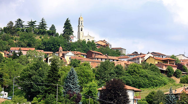
Aramengo (Aramengo)

- Italian comune
 Hiking in Aramengo
Aramengo, located in northern Italy within the Piedmont region, is a charming destination for hikers. The area is characterized by its picturesque landscapes, rolling hills, and a network of trails that cater to various skill levels.
Hiking Features in Aramengo:
-
Scenic Routes: The trails often wind through vineyards, orchards, and forests, offering breathtaking views of the surrounding countryside. The paths can lead you to historical sites and quaint villages, enhancing your hiking experience.
-
Trail Difficulty: There are a range of trails available, from easy walks suitable for families to more challenging routes for experienced hikers. Make sure to check trail markers and local guides to choose the best route for your skill level.
-
Wildlife and Flora: The region is home to diverse flora and fauna. You may encounter various bird species and small mammals along the trails. The changing seasons also offer different displays of wildflowers and foliage.
-
Local Culture: Hiking in Aramengo is not just about the trails; the area is rich in local culture. You can explore regional cuisine at local taverns and enjoy traditional events, which further immerses you in the local lifestyle.
-
Safety Considerations: Always check the weather forecast before heading out, wear appropriate hiking gear, carry sufficient water, and consider bringing a map or using a hiking app for navigation.
-
Best Times to Hike: Spring and fall are ideal times for hiking in Aramengo, as temperatures are pleasant and the landscapes are at their most vibrant.
Recommendations:
- Make sure to visit local tourism offices for maps and guided tours.
- Consider joining a hiking group or local guide to enhance your experience and learn more about the area.
- Respect the environment by staying on marked trails and following Leave No Trace principles.
Whether you're a seasoned hiker or just looking for a leisurely stroll, Aramengo offers a unique outdoor experience framed by the beauty of northern Italy's landscape.
- Country:

- Postal Code: 14020
- Local Dialing Code: 0141
- Licence Plate Code: AT
- Coordinates: 45° 6' 6" N, 8° 0' 4" E


- GPS tracks (wikiloc): [Link]
- AboveSeaLevel: 357 м m
- Area: 11.41 sq km
- Population: 592
- Web site: http://www.comune.aramengo.at.it/
- Wikipedia en: wiki(en)
- Wikipedia: wiki(it)
- Wikidata storage: Wikidata: Q17745
- Wikipedia Commons Category: [Link]
- Freebase ID: [/m/0gbfkv]
- GeoNames ID: Alt: [6543478]
- VIAF ID: Alt: [245883059]
- OSM relation ID: [44160]
- ISTAT ID: 005004
- Italian cadastre code: A352
Shares border with regions:

Albugnano
- Italian comune
Hiking in Albugnano
Albugnano, located in the stunning Piedmont region of Italy, is a great destination for hiking enthusiasts. This area is characterized by its rolling hills, vineyards, and picturesque landscapes, making it an ideal spot for both relaxed walks and more challenging hikes....
- Country:
- Postal Code: 14020
- Local Dialing Code: 011
- Licence Plate Code: AT
- Coordinates: 45° 4' 43" N, 7° 58' 20" E
- GPS tracks (wikiloc): [Link]
- AboveSeaLevel: 549 м m
- Area: 9.54 sq km
- Population: 508
- Web site: [Link]


Berzano di San Pietro
- Italian comune
Hiking in Berzano di San Pietro
Berzano di San Pietro is a charming village located in the Piedmont region of Italy, known for its beautiful landscapes and tranquil environment. If you're considering hiking in this area, there are several factors and trails to keep in mind:...
- Country:
- Postal Code: 14020
- Local Dialing Code: 011
- Licence Plate Code: AT
- Coordinates: 45° 5' 45" N, 7° 57' 14" E
- GPS tracks (wikiloc): [Link]
- AboveSeaLevel: 424 м m
- Area: 7.34 sq km
- Population: 415
- Web site: [Link]


Cocconato
- Italian comune
Hiking in Cocconato
Cocconato is a charming town located in the Piedmont region of Italy, known for its picturesque landscapes, rolling hills, and rich cultural heritage. The area surrounding Cocconato offers a variety of hiking opportunities, making it an excellent destination for outdoor enthusiasts....
- Country:
- Postal Code: 14023
- Local Dialing Code: 0141
- Licence Plate Code: AT
- Coordinates: 45° 5' 20" N, 8° 2' 26" E
- GPS tracks (wikiloc): [Link]
- AboveSeaLevel: 491 м m
- Area: 16.52 sq km
- Population: 1452
- Web site: [Link]


Passerano Marmorito
- Italian comune
Hiking in Passerano Marmorito
Passerano Marmorito is a charming municipality located in the Province of Asti in the Piedmont region of Italy. The area is characterized by rolling hills, vineyards, and a serene countryside, making it an attractive destination for outdoor enthusiasts and hikers....
- Country:
- Postal Code: 14020
- Local Dialing Code: 0141
- Licence Plate Code: AT
- Coordinates: 45° 3' 24" N, 8° 1' 11" E
- GPS tracks (wikiloc): [Link]
- AboveSeaLevel: 320 м m
- Area: 12.03 sq km
- Population: 442
- Web site: [Link]


Tonengo
- Italian comune
Hiking in Tonengo
It seems there might be a misunderstanding regarding the location "Tonengo." As of my last knowledge update in October 2023, there isn't a well-known hiking destination by that name. However, if you meant a different location or a specific regional hiking area—perhaps somewhere like the Tonengor Mountains or a similarly named area—please provide additional details....
- Country:
- Postal Code: 14023
- Local Dialing Code: 0141
- Licence Plate Code: AT
- Coordinates: 45° 7' 7" N, 8° 0' 12" E
- GPS tracks (wikiloc): [Link]
- AboveSeaLevel: 430 м m
- Area: 5.6 sq km
- Population: 244
- Web site: [Link]


Casalborgone
- Italian comune
Hiking in Casalborgone
Casalborgone is a charming town located in the Piedmont region of Italy, surrounded by beautiful natural landscapes that offer various hiking opportunities. The area is characterized by its rolling hills, vineyards, and scenic views of the surrounding countryside....
- Country:
- Postal Code: 10020
- Local Dialing Code: 011
- Licence Plate Code: TO
- Coordinates: 45° 8' 0" N, 7° 56' 0" E
- GPS tracks (wikiloc): [Link]
- AboveSeaLevel: 205 м m
- Area: 20.13 sq km
- Population: 1885
- Web site: [Link]