Passerano Marmorito (Passerano Marmorito)

- Italian comune
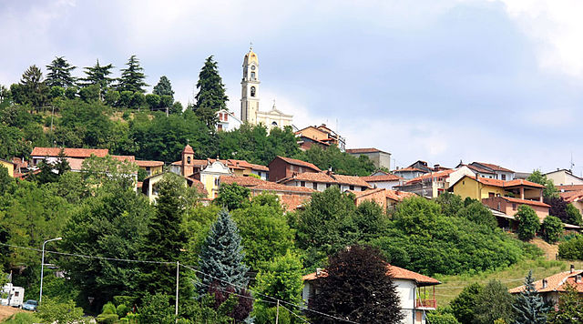
 Hiking in Passerano Marmorito
Passerano Marmorito is a charming municipality located in the Province of Asti in the Piedmont region of Italy. The area is characterized by rolling hills, vineyards, and a serene countryside, making it an attractive destination for outdoor enthusiasts and hikers.
Hiking Opportunities
-
Scenic Trails: The region offers a variety of walking and hiking trails that showcase the natural beauty of the Italian countryside. Many trails take you through vineyards, orchards, and wooded areas, providing beautiful views of the landscape.
-
Local Flora and Fauna: As you hike around Passerano Marmorito, you may encounter diverse plant species and wildlife native to the region, enhancing your nature experience.
-
Cultural Sites: While hiking, you might also come across historical sites, churches, and local farms, providing insight into the cultural heritage of the area.
-
Vineyard Tours: Given the region’s renowned wine production, some hiking routes may lead to local vineyards where you can take part in wine tastings or learn about the winemaking process.
-
Difficulty Levels: Trails in and around Passerano Marmorito cater to various skill levels, from easy walks suitable for families to more challenging hikes for experienced adventurers.
Tips for Hiking in Passerano Marmorito
- Proper Footwear: Make sure to wear sturdy hiking shoes to navigate uneven terrain comfortably.
- Weather Considerations: Check the weather before heading out, as conditions can change rapidly, especially in spring and fall.
- Trail Maps: Utilize local maps or GPS apps to stay on track; some trails might not be well-marked.
- Stay Hydrated: Always carry enough water and snacks, especially on longer hikes.
- Respect Nature: Follow the Leave No Trace principles to preserve the natural beauty of the area.
Conclusion
Hiking in Passerano Marmorito can be a delightful experience, combining nature, culture, and local gastronomy. Whether you are looking for a peaceful walk through the vineyards or a more strenuous hike through the hills, there’s something to suit every hiker's taste. Enjoy your time exploring this beautiful part of Italy!
- Country:

- Postal Code: 14020
- Local Dialing Code: 0141
- Licence Plate Code: AT
- Coordinates: 45° 3' 24" N, 8° 1' 11" E


- GPS tracks (wikiloc): [Link]
- AboveSeaLevel: 320 м m
- Area: 12.03 sq km
- Population: 442
- Web site: http://www.comune.passeranomarmorito.at.it/
- Wikipedia en: wiki(en)
- Wikipedia: wiki(it)
- Wikidata storage: Wikidata: Q17841
- Wikipedia Commons Category: [Link]
- Freebase ID: [/m/0gbhvc]
- GeoNames ID: Alt: [6542458]
- VIAF ID: Alt: [265421897]
- OSM relation ID: [44025]
- UN/LOCODE: [ITPSU]
- ISTAT ID: 005082
- Italian cadastre code: G358
Shares border with regions:

Albugnano
- Italian comune
Hiking in Albugnano
Albugnano, located in the stunning Piedmont region of Italy, is a great destination for hiking enthusiasts. This area is characterized by its rolling hills, vineyards, and picturesque landscapes, making it an ideal spot for both relaxed walks and more challenging hikes....
- Country:
- Postal Code: 14020
- Local Dialing Code: 011
- Licence Plate Code: AT
- Coordinates: 45° 4' 43" N, 7° 58' 20" E
- GPS tracks (wikiloc): [Link]
- AboveSeaLevel: 549 м m
- Area: 9.54 sq km
- Population: 508
- Web site: [Link]


Aramengo
- Italian comune
Hiking in Aramengo
Aramengo, located in northern Italy within the Piedmont region, is a charming destination for hikers. The area is characterized by its picturesque landscapes, rolling hills, and a network of trails that cater to various skill levels....
- Country:
- Postal Code: 14020
- Local Dialing Code: 0141
- Licence Plate Code: AT
- Coordinates: 45° 6' 6" N, 8° 0' 4" E
- GPS tracks (wikiloc): [Link]
- AboveSeaLevel: 357 м m
- Area: 11.41 sq km
- Population: 592
- Web site: [Link]
Capriglio
- Italian comune
Hiking in Capriglio
Capriglio is a charming village located in the Piedmont region of Italy, near the Monferrato area. The surrounding landscape features rolling hills, vineyards, and woodlands, making it an appealing destination for hiking enthusiasts. Here are some highlights of hiking in and around Capriglio:...
- Country:
- Postal Code: 14014
- Local Dialing Code: 0141
- Licence Plate Code: AT
- Coordinates: 45° 0' 13" N, 8° 0' 32" E
- GPS tracks (wikiloc): [Link]
- AboveSeaLevel: 231 м m
- Area: 5.06 sq km
- Population: 288
- Web site: [Link]


Castelnuovo Don Bosco
- Italian comune
Hiking in Castelnuovo Don Bosco
Castelnuovo Don Bosco is a charming town located in the Piedmont region of Italy, renowned for its beautiful landscapes and rich history. The area offers several hiking opportunities that allow you to enjoy its natural beauty, vineyards, and scenic views....
- Country:
- Postal Code: 14022
- Local Dialing Code: 011
- Licence Plate Code: AT
- Coordinates: 45° 2' 30" N, 7° 57' 51" E
- GPS tracks (wikiloc): [Link]
- AboveSeaLevel: 306 м m
- Area: 21.61 sq km
- Population: 3195
- Web site: [Link]
Cerreto d'Asti
- Italian comune
Hiking in Cerreto d'Asti
Cerreto d'Asti is a charming town located in the Piedmont region of Italy, surrounded by beautiful landscapes that make it an excellent destination for hiking enthusiasts. The area is characterized by rolling hills, vineyards, and picturesque views of the Asti countryside....
- Country:
- Postal Code: 14020
- Local Dialing Code: 0141
- Licence Plate Code: AT
- Coordinates: 45° 3' 11" N, 8° 2' 10" E
- GPS tracks (wikiloc): [Link]
- AboveSeaLevel: 280 м m
- Area: 4.82 sq km
- Population: 229
- Web site: [Link]


Cocconato
- Italian comune
Hiking in Cocconato
Cocconato is a charming town located in the Piedmont region of Italy, known for its picturesque landscapes, rolling hills, and rich cultural heritage. The area surrounding Cocconato offers a variety of hiking opportunities, making it an excellent destination for outdoor enthusiasts....
- Country:
- Postal Code: 14023
- Local Dialing Code: 0141
- Licence Plate Code: AT
- Coordinates: 45° 5' 20" N, 8° 2' 26" E
- GPS tracks (wikiloc): [Link]
- AboveSeaLevel: 491 м m
- Area: 16.52 sq km
- Population: 1452
- Web site: [Link]


Pino d'Asti
- Italian comune
Hiking in Pino d'Asti
Pino d'Asti, located in the Piedmont region of Italy, is a charming area that offers a variety of outdoor activities, including hiking. Nestled among rolling hills and vineyards, the region is known for its picturesque landscapes and serene environment, making it a wonderful destination for hikers of all experience levels. Here are some key points about hiking in Pino d'Asti:...
- Country:
- Postal Code: 14020
- Local Dialing Code: 011
- Licence Plate Code: AT
- Coordinates: 45° 3' 30" N, 7° 59' 14" E
- GPS tracks (wikiloc): [Link]
- AboveSeaLevel: 412 м m
- Area: 4.08 sq km
- Population: 225
- Web site: [Link]


Piovà Massaia
- Italian comune
Hiking in Piovà Massaia
Piovà Massaia is a charming municipality located in the Piedmont region of Italy, nestled in the province of Asti. This area is characterized by its picturesque landscapes, rolling hills, and vineyards, making it an attractive destination for hiking enthusiasts....
- Country:
- Postal Code: 14020
- Local Dialing Code: 0141
- Licence Plate Code: AT
- Coordinates: 45° 3' 22" N, 8° 3' 4" E
- GPS tracks (wikiloc): [Link]
- AboveSeaLevel: 300 м m
- Area: 10.14 sq km
- Population: 621
- Web site: [Link]